Balestrand is a municipality in Sogn og Fjordane county, Norway. It is located on the northern shore of the Sognefjorden in the traditional district of Sogn. The administrative center is the village of Balestrand. Other villages in the municipality include Ese, Kvamme, Låne, Sæle, Tjugum, and Vetlefjorden.

Askvoll (help·info) is a municipality in Sogn og Fjordane county, Norway. It is located in the traditional district of Sunnfjord. The administrative centre is the village of Askvoll. Other villages in the municipality include Holmedal, Kvammen, and Stongfjorden. The most important industries in Askvoll today are Helle Knivfabrikk, Bulandet Fiskeindustri, and Sigurd Løkeland Hermetikkfabrikk.

Fjaler is a municipality in the county of Sogn og Fjordane, Norway. It is located in the traditional district of Sunnfjord. The administrative centre is the village of Dale. Other places in Fjaler include Espedal, Flekke, Folkestad, Guddal, and Hellevika.

Gaular is a municipality in Sogn og Fjordane county, Norway. It is located in the traditional district of Sunnfjord. The administrative centre is the village of Sande. Other villages in the municipality include Bygstad, Hestad, and Vik. Gaular is sometimes referred to as Fosselandet because it is home to 28 large and small waterfalls. The municipality is centered on the river Gaula. The Viksdalen valley is located in Gaular.

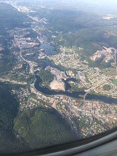
Førde is a municipality in the county of Sogn og Fjordane, Norway. It is located in the traditional district of Sunnfjord. The administrative center is the town of Førde which in 2016 had 10,255 inhabitants. Other villages in Førde municipality include Bruland, Holsen, Moskog, and Haukedalen. The Øyrane area in the town of Førde is a large industrial/commercial area for the region. The European Route E39 highway goes through the municipality, and it passes by the lake Holsavatnet.

Sande is the administrative centre of the municipality of Gaular in Sogn og Fjordane county, Norway. The village is located along the Gaula River, about 10 kilometres (6.2 mi) from where the river meets the Dalsfjorden. The 0.59-square-kilometre (150-acre) village has a population (2013) of 745, giving the village a population density of 1,263 inhabitants per square kilometre (3,270/sq mi). Sande Church is located in this village, serving the people of the central part of the municipality.

Dale or Dale i Sunnfjord is the administrative centre of the municipality of Fjaler in Sogn og Fjordane county, Norway. The village is located at the mouth of the river Vassdalselva on the southern shore of the Dalsfjorden in the northern part of Fjaler, about 6.5 kilometres (4.0 mi) northeast of the village of Flekke and about 20 kilometres (12 mi) west of the village of Bygstad.

The Gaula is a river located in the Sunnfjord region of Sogn og Fjordane county, Norway. The 63-kilometre (39 mi) long river is the central part of the Gaularvassdraget watershed basin which covers about 626 square kilometres (242 sq mi) across the municipalities of Gaular, Sogndal, and Førde. The river is a good salmon fishing river. The river runs across the whole municipality of Gaular, and the river is the namesake of the municipality.

Sparbu is a village in the municipality of Steinkjer in Trøndelag county, Norway. The village is located about 12 kilometres (7.5 mi) south of the town of Steinkjer. The European route E6 highway runs through the village as does the Nordlandsbanen railway line which stops at the Sparbu Station. The village of Mære lies about 2 kilometres (1.2 mi) to the north, the village of Røra lies about 8 kilometres (5.0 mi) to the south, and the lake Leksdalsvatnet lies about 8 kilometres (5.0 mi) to the east.

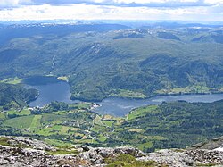
Vik is a village in Gaular Municipality in Sogn og Fjordane county, Norway. The village is located on the north shore of the river Gaula, on the eastern end of the lake Viksdalsvatnet. The Norwegian County Road 13 highway runs through Vik, on its way from Førde to the north to Balestrand to the south. The Viksdalen Church is located in the village, and it serves the people in the Viksdalen valley of eastern Gaular. This has been a church site for centuries. The first known church in Vik was named in historical records in 1360, so it was built sometime before then.
Hestad is a village in Gaular Municipality in Sogn og Fjordane county, Norway. The village is located on the northern shore of the river Gaula. The village is located just north of a very small peninsula that is about 20 metres (66 ft) wide by 400 metres (1,300 ft) long. The peninsula juts south into the river, separating the two lakes. The forested peninsula is the site of Hestad Chapel and it has been a church site for centuries. There was originally an old stave church on the site that was built in the 14th century.
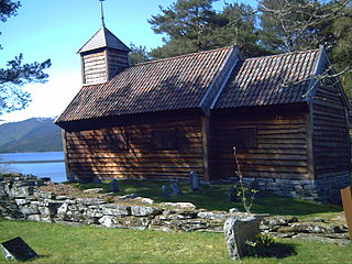
Hestad Chapel is a chapel located in Gaular Municipality in Sogn og Fjordane county, Norway. It is situated in the village of Hestad, on a small peninsula jutting into the Hestadfjorden, a lake that is part of the river Gaula. Because of its location on a small "island"-like peninsula, the church is also known as the Øyrakyrkja. The chapel is part of the Viksdalen parish in the Sunnfjord deanery in the Diocese of Bjørgvin.

Viksdalen Church is the main parish church in Gaular Municipality in Sogn og Fjordane county, Norway. It is located in the village of Vik. The church is part of the Viksdalen parish in the Sunnfjord deanery in the Diocese of Bjørgvin. The white, wooden church, which has 284 seats, was consecrated on 5 November 1848 by Dean Johan Grønnlund. The church was probably built using architectural drawings by Hans Linstow.
Sande Church is a parish church in Gaular Municipality in Sogn og Fjordane county, Norway. It is located in the village of Sande. The church is part of the Viksdalen parish in the Sunnfjord deanery in the Diocese of Bjørgvin. The white, wooden church was built in 1864 using architectural drawings by Hans Linstow, and it was significantly rebuilt in the 1940s using drawings by Johan Lindstrøm. The church seats about 300 people and it was consecrated on 5 December 1864.
Stongfjorden Chapel is a chapel in Gaular Municipality in Sogn og Fjordane county, Norway. It is located in the village of Stongfjorden. The chapel is part of the Askvoll parish in the Sunnfjord deanery in the Diocese of Bjørgvin. The white, wooden chapel seats about 300, and it was built in 1908 as a bedehus. Soon after, it was consecrated for regular church use on 6 December 1914 by the Dean Jonas Rein Landmark. The architect Martinus Haugen made the original designs for the chapel. There have been some additions and renovations since that time.
Vennesla is the administrative centre of Vennesla municipality in Vest-Agder county, Norway. The village is located in the upper Torridal valley along the river Otra, about 15 kilometres (9.3 mi) north of the city of Kristiansand. The village itself extends for about 10 kilometres (6.2 mi) along both sides of the river. The Norwegian National Road 9 passes through Mosby, about 6 kilometres (3.7 mi) south of Vennesla. The Sørlandsbanen railway line passes through Vennesla, stopping at Vennesla Station. The lake Venneslafjorden is located on the river Otra in the northern part of the village of Vennesla.