| Sande Sande i Sunnfjord | |
|---|---|
| Village | |
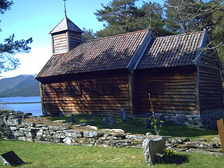
Sande Church | |
 Sande Location in Sogn og Fjordane county  Sande Sande (Norway) | |
| Coordinates: 61°19′30″N05°47′51″E / 61.32500°N 5.79750°E Coordinates: 61°19′30″N05°47′51″E / 61.32500°N 5.79750°E | |
| Country | Norway |
| Region | Western Norway |
| County | Sogn og Fjordane |
| District | Sunnfjord |
| Municipality | Gaular |
| Area [1] | |
| • Total | 0.59 km2 (0.23 sq mi) |
| Elevation [2] | 100 m (300 ft) |
| Population (2013) [1] | |
| • Total | 745 |
| • Density | 1,263/km2 (3,270/sq mi) |
| Time zone | CET (UTC+01:00) |
| • Summer (DST) | CEST (UTC+02:00) |
| Post Code | 6973 Sande i Sunnfjord |

Sande (also known as Sande i Sunnfjord) is the administrative centre of the municipality of Gaular in Sogn og Fjordane county, Norway. The village is located along the Gaula River, about 10 kilometres (6.2 mi) from where the river meets the Dalsfjorden. The 0.59-square-kilometre (150-acre) village has a population (2013) of 745, giving the village a population density of 1,263 inhabitants per square kilometre (3,270/sq mi). [1] Sande Church is located in this village, serving the people of the central part of the municipality.
An administrative centre is a seat of regional administration or local government, or a county town, or the place where the central administration of a commune is located.

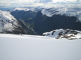
Gaular is a municipality in Sogn og Fjordane county, Norway. It is located in the traditional district of Sunnfjord. The administrative centre is the village of Sande. Other villages in the municipality include Bygstad, Hestad, and Vik. Gaular is sometimes referred to as Fosselandet because it is home to 28 large and small waterfalls. The municipality is centered on the river Gaula. The Viksdalen valley is located in Gaular.

Sogn og Fjordane is a county in western Norway, bordering Møre og Romsdal, Oppland, Buskerud, and Hordaland. The county administration is in the village of Hermansverk in Leikanger municipality. The largest town in the county is Førde.
The European route E39 highway runs through the village of Sande, connecting it to the village of Vadheim to the south and the town of Førde to the north. Førde Airport, Bringeland is located about 11 kilometres (6.8 mi) north of Sande along the E39 highway. The town of Førde is 19 kilometres (12 mi) north of Sande, and the village of Vadheim in Høyanger is 14 kilometres (8.7 mi) to the south. [3]

E 39 is the designation of a 1330 km long north-south road in Norway and Denmark, running from Klett just south of Trondheim to Aalborg, via Orkanger, Vinjeøra, Halsa ... Straumsnes, Krifast, Batnfjordsøra, Molde ... Vestnes, Skodje, Ålesund ... Volda ... Nordfjordeid ... Sandane, Førde, Lavik ... Instefjord, Knarvik, Bergen, Os ... Stord, Sveio, Aksdal, Bokn ... Rennesøy, Randaberg, Stavanger, Sandnes, Ålgård, Helleland, Flekkefjord, Lyngdal, Mandal, Kristiansand ... Hirtshals, Hjørring, and Nørresundby. Several sections are via ferry, denoted by ... in the above list. In total there are nine ferries, the highest number of ferries for a single road in Europe.

Vadheim is a village in the municipality of Høyanger in Sogn og Fjordane county, Norway. It is located on the north shore of the Sognefjorden, along the small Vadheimsfjorden branch. The European route E39 highway runs through the village. It is located about 25 kilometres (16 mi) northeast of the village of Lavik, about 11 kilometres (6.8 mi) northwest of the village of Kyrkjebø, and about 13.5 kilometres (8.4 mi) northwest of the village of Austreim. The 0.36-square-kilometre (89-acre) village has a population (2013) of 238, giving the village a population density of 661 inhabitants per square kilometre (1,710/sq mi).

Førde is the administrative centre of Førde Municipality in Sogn og Fjordane county, Norway. The town is located at the eastern end of the Førdefjorden, at the mouth of the river Jølstra. The 5.58-square-kilometre (1,380-acre) town has a population (2013) of 10,099; giving the town a population density of 1,810 inhabitants per square kilometre (4,700/sq mi).