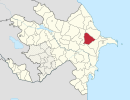
Coordinates: 40°31′N49°15′E / 40.517°N 49.250°E
A geographic coordinate system is a coordinate system that enables every location on Earth to be specified by a set of numbers, letters or symbols. The coordinates are often chosen such that one of the numbers represents a vertical position and two or three of the numbers represent a horizontal position; alternatively, a geographic position may be expressed in a combined three-dimensional Cartesian vector. A common choice of coordinates is latitude, longitude and elevation. To specify a location on a plane requires a map projection.
Cəngi | |
---|---|
Coordinates: 40°31′N49°15′E / 40.517°N 49.250°E | |
Country | |
Rayon | Gobustan |
Municipality | Nabur |
Time zone | AZT (UTC+4) |
• Summer (DST) | AZT (UTC+5) |
Cəngi (also, Dzhangi) is a village in the Gobustan Rayon of Azerbaijan. The village forms part of the municipality of Nabur. [1]
Azerbaijan, officially the Republic of Azerbaijan, is a country in the South Caucasus region of Eurasia at the crossroads of Eastern Europe and Western Asia. It is bounded by the Caspian Sea to the east, Russia to the north, Georgia to the northwest, Armenia to the west and Iran to the south. The exclave of Nakhchivan is bounded by Armenia to the north and east, Iran to the south and west, and has an 11 km long border with Turkey in the northwest.
Nabur is a village and municipality in the Gobustan Rayon of Azerbaijan. It has a population of 2,726. The municipality consists of the villages of Nabur and Cəngi.
Aşağı Qəsil is a village in the Agdash Rayon of Azerbaijan. The village forms part of the municipality of Qulbəndə.
Orta Qəsil is a village in the Agdash Rayon of Azerbaijan. The village forms part of the municipality of Qulbəndə.
Qazaxlı is a village in the Dashkasan Rayon of Azerbaijan. The village forms part of the municipality of Əmirvar.
Yenikənd is a village in the Goychay Rayon of Azerbaijan. The village forms part of the municipality of Kürdşaban.
İkinci Yeniyol is a village in the Ismailli Rayon of Azerbaijan. The village forms part of the municipality of Birinci Yeniyol.
Dərəkərkənc is a village in the Shamakhi Rayon of Azerbaijan.
Hüseynqulular is a village in the Tovuz Rayon of Azerbaijan. The village forms part of the municipality of Göyəbaxan.
Hacallı is a village in the Tovuz Rayon of Azerbaijan.
Musayal is a village in the Gadabay Rayon of Azerbaijan. The village forms part of the municipality of Dəyəqarabulaq.
Bala Surra is a village in the Neftchala Rayon of Azerbaijan. The village forms part of the municipality of Ərəbqardaşbəyli.
Upa is a village in the Khizi Rayon of Azerbaijan.
Sadafli is a village in the Yevlakh Rayon of Azerbaijan.
Ochotnica Górna is a village in the administrative district of Gmina Ochotnica Dolna, within Nowy Targ County, Lesser Poland Voivodeship, in southern Poland. It lies approximately 6 kilometres (4 mi) west of Ochotnica Dolna, 18 km (11 mi) east of Nowy Targ, and 65 km (40 mi) south of the regional capital Kraków.
Sədiyan is a village in the municipality of Diyallı in the Ismailli Rayon of Azerbaijan.
Üzümçü is a village in the municipality of Bədəlli in the Gobustan Rayon of Azerbaijan.
Dəvrallı is a village in the municipality of Tapan in the Dashkasan Rayon of Azerbaijan.
Lomin is a village and municipality in the Astara Rayon of Azerbaijan. It has a population of 549. The municipality consists of the villages of Lomin and Vovlada.
İkinci Dördyol is a village in the municipality of Təzəkənd in the Agdam Rayon of Azerbaijan.
Qaralı is a village and municipality in the Sabirabad Rayon of Azerbaijan. It has a population of 658.
Xankəndi is a village in the Shamakhi Rayon of Azerbaijan.
This Gobustan Rayon location article is a stub. You can help Wikipedia by expanding it. |