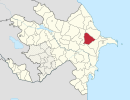
Coordinates: 40°29′19″N49°03′46″E / 40.48861°N 49.06278°E
A geographic coordinate system is a coordinate system that enables every location on Earth to be specified by a set of numbers, letters or symbols. The coordinates are often chosen such that one of the numbers represents a vertical position and two or three of the numbers represent a horizontal position; alternatively, a geographic position may be expressed in a combined three-dimensional Cartesian vector. A common choice of coordinates is latitude, longitude and elevation. To specify a location on a plane requires a map projection.
Ceyrankeçməz | |
---|---|
Coordinates: 40°29′19″N49°03′46″E / 40.48861°N 49.06278°E | |
Country | |
Rayon | Gobustan |
Municipality | Şıxzahırlı |
Time zone | AZT (UTC+4) |
• Summer (DST) | AZT (UTC+5) |
Ceyrankeçməz (also, Dzheiran-Kechmas, Dzheyran-Kechmas, and Dzheyrankechmaz) is a village in the Gobustan Rayon of Azerbaijan. The village forms part of the municipality of Şıxzahırlı. [1]
Azerbaijan, officially the Republic of Azerbaijan, is a country in the South Caucasus region of Eurasia at the crossroads of Eastern Europe and Western Asia. It is bounded by the Caspian Sea to the east, Russia to the north, Georgia to the northwest, Armenia to the west and Iran to the south. The exclave of Nakhchivan is bounded by Armenia to the north and east, Iran to the south and west, and has an 11 km long border with Turkey in the northwest.
Şıxzahırlı is a village and municipality in the Gobustan Rayon of Azerbaijan. It has a population of 1,589. The municipality consists of the villages of Şıxzahirli, Ceyrankeçməz, and Ilanlı.
Morašice is a village in the Pardubice Region of the Czech Republic. It has around 110 inhabitants.
Aragats ; known as Ghaznafar until 1948, is a village in the eastern part of the Aragatsotn Province of Armenia.
Perekeshkul is a village in the Absheron Rayon of Azerbaijan. The village forms part of the municipality of Pirəkəşkül-Qobustan.
Pirəköcə is a village and municipality in the Kurdamir Rayon of Azerbaijan.
Ərəbxana is a village and municipality in the Kurdamir Rayon of Azerbaijan.
Qədimkənd is a village and municipality in the Neftchala Rayon of Azerbaijan. It has a population of 2,320. The municipality consists of the villages of Qədimkənd and Birinci Qaralı.
Hat is a village in the Qubadli Rayon of Azerbaijan. Hat is the Azeri village in Qubadli
Yaşma is a village in the Khizi Rayon of Azerbaijan. The village forms part of the municipality of Şuraabad.
Qars is a former village in the Khizi Rayon of Azerbaijan. The village formed part of the municipality of Tıxlı.
Rəzdərə is a village in the Zangilan Rayon of Azerbaijan.
Upa is a village in the Khizi Rayon of Azerbaijan.
Germiyan is a village in the Khizi Rayon of Azerbaijan.
Tudar is a village in the Khizi Rayon of Azerbaijan. The village forms part of the municipality of Ağdərə.
Dizəvər is a village in the Khizi Rayon of Azerbaijan. The village forms part of the municipality of Qarabulaq.
Lipicze is a village in the administrative district of Gmina Klonowa, within Sieradz County, Łódź Voivodeship, in central Poland. It lies approximately 6 kilometres (4 mi) east of Klonowa, 27 km (17 mi) south-west of Sieradz, and 79 km (49 mi) south-west of the regional capital Łódź.
Skrzyszów is a village in Tarnów County, Lesser Poland Voivodeship, in southern Poland. It is the seat of the gmina called Gmina Skrzyszów. It lies approximately 7 kilometres (4 mi) south-east of Tarnów and 81 km (50 mi) east of the regional capital Kraków.
Maarif is a village in the Gadabay Rayon of Azerbaijan. The village forms part of the municipality of Slavyanka.
Kazimierzów is a village in the administrative district of Gmina Stoczek, within Węgrów County, Masovian Voivodeship, in east-central Poland. It lies approximately 11 kilometres (7 mi) north of Węgrów and 73 km (45 mi) north-east of Warsaw.
Gorzków Stary is a village in the administrative district of Gmina Niegowa, within Myszków County, Silesian Voivodeship, in southern Poland. It lies approximately 4 kilometres (2 mi) north of Niegowa, 17 km (11 mi) north-east of Myszków, and 59 km (37 mi) north-east of the regional capital Katowice.
Janinów is a village in the administrative district of Gmina Rudniki, within Olesno County, Opole Voivodeship, in south-western Poland. It lies approximately 3 kilometres (2 mi) north-east of Rudniki, 25 km (16 mi) north-east of Olesno, and 65 km (40 mi) north-east of the regional capital Opole.
This Gobustan Rayon location article is a stub. You can help Wikipedia by expanding it. |