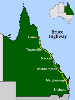
The Bruce Highway is a major highway in Queensland, Australia. Commencing in the state capital, Brisbane, it passes through areas close to the eastern coast on its way to Cairns in Far North Queensland. The route is part of the Australian National Highway and also part of Highway 1. Its length is approximately 1,679 kilometres (1,043 mi); it is entirely sealed with bitumen. The highway is named after a popular former Queensland and federal politician, Harry Bruce. Bruce was the state Minister for Works when the highway was named after him, in the mid-1930s, and was widely considered to be a good bloke. The highway once passed through Brisbane, but was truncated at Bald Hills when the Gateway Motorway became National Highway 1 upon its opening in December 1986.
King's Highway 101, commonly referred to as Highway 101, is a provincially maintained highway in the Canadian province of Ontario. The 473.3-kilometre (294.1 mi) highway connects Highway 17 west of Wawa with Highway 11 in Matheson before continuing east to the Ontario–Quebec border where it becomes Route 388. The highway forms one of the only connections between the two routes of the Trans-Canada Highway between Nipigon and Temagami, and crosses some of the most remote regions of Northern Ontario. Major junctions are located with Highway 129 near Chapleau and Highway 144 southwest of Timmins, though the distance between these junctions is significant.
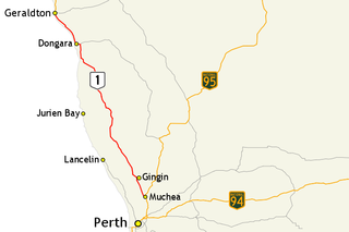
Brand Highway is a 370-kilometre (230 mi) main highway linking the northern outskirts of Perth, the capital of Western Australia, to the port city of Geraldton in Western Australia's Mid West region. Together with North West Coastal Highway, it forms part of the Western Australian coastal link to the Northern Territory. The highway is a part of Australia's Highway 1, and is for the most part a single carriageway with one lane in each direction.
King's Highway 60, commonly referred to as Highway 60, is a provincially maintained highway in the Canadian province of Ontario. The 255.8-kilometre (158.9 mi) highway serves as the primary corridor through Algonquin Provincial Park, where it is dedicated as the Frank McDougall Parkway. East of Algonquin Park, the route serves east–west traffic in the highlands of central Ontario. It begins at Highway 11 in Huntsville and ends at Highway 17 near Renfrew.

The Kidman Way is a state rural road in the western Riverina and western region of New South Wales, Australia. The 644-kilometre (400 mi) highway services the Murrumbidgee Irrigation Area and outback communities and links the Newell Highway with the Sturt, Mid-Western, Barrier, Mitchell and Kamilaroi highways. The road carries the State Route B87 shield for its entire route, with its northern terminus at Bourke and its southern terminus at a junction with the Newell Highway, situated 16 kilometres (10 mi) north of Jerilderie. The Kidman Way is fully sealed and is accessible by two or four-wheel drive.

Alberta Provincial Highway No. 21, commonly referred to as Highway 21, is a north-south highway in Alberta, Canada that parallels Highway 2 between Calgary and Edmonton. It is approximately 328 kilometres (204 mi) in length. It begins at the Trans-Canada Highway (Highway 1) east of Strathmore, and ends at Fort Saskatchewan where it is succeeded by Highway 15. The northernmost 25 kilometres (16 mi) of the highway are twinned. Highway 21 runs roughly parallel to the main north-south CN rail line between Calgary and Edmonton between Three Hills and Looma.

Alberta Provincial Highway No. 28, commonly referred to as Highway 28, is a highway in north-central Alberta, Canada that connects Edmonton to Cold Lake. It begins at Yellowhead Trail (Highway 16) in Edmonton as 97 Street NW, running through the city's north suburbs before entering Sturgeon County and passing CFB Edmonton. After merging with Highway 28A near Gibbons it winds through agricultural lands of north-central Alberta, roughly paralleling the North Saskatchewan River until Smoky Lake before continuing east through St. Paul County to Bonnyville. It turns northeast to CFB Cold Lake, before ending at Lakeshore Drive in the city of Cold Lake shortly thereafter.
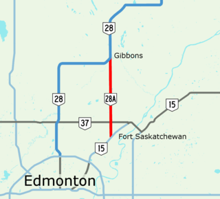
Alberta Provincial Highway No. 28A, commonly referred to as Highway 28A, is an 18-kilometre (11 mi) highway in Alberta, Canada that connects Highway 15 in northeast Edmonton to Highway 28 near Gibbons. It is numbered 17 Street NE within Edmonton and forms an alternate route to Highway 28 into the city from the north. As the southernmost component of the Edmonton–Fort McMurray corridor, the highway is designated as a core route of Canada's National Highway System for its entire length.

Alberta Provincial Highway No. 39, commonly referred to as Highway 39, is an east–west highway in central Alberta, Canada. It extends from Highway 22, approximately 13 kilometres (8 mi) east of Drayton Valley, to Leduc where it ends at Highway 2. Highway 39 is about 91 kilometres (57 mi) long.
King's Highway 108, commonly referred to as Highway 108, is a provincially maintained highway in the Canadian province of Ontario. Located in the Algoma District in the mid-north region, just above Lake Huron, of the province, the highway extends for 41.6 kilometres (25.8 mi) from an intersection with Highway 17 west of Serpent River, through the urban core of Elliot Lake, to an intersection with Quirke Mine Road in the north end of the city. The highway continues as Secondary Highway 639 north of Quirke Mine Road.

Alberta Provincial Highway No. 55, commonly referred to as Highway 55, is a 263-kilometre (163 mi) long east–west highway in northeast Alberta, Canada. It extends from the Saskatchewan border in the east through the Cold Lake, Lac La Biche, and Athabasca where it ends at Highway 2. In Saskatchewan, it continues as Saskatchewan Highway 55.

Secondary Highway 560, commonly referred to as Highway 560, is a provincially maintained secondary highway in the northern section of the Canadian province of Ontario. It begins in the west at an intersection with Highway 144 and the Sultan Industrial Road and proceeds 184.1 kilometres (114.4 mi) east to Highway 11 at Englehart.
King's Highway 132, commonly referred to as Highway 132, is a provincially maintained highway the Canadian province of Ontario. Its western terminus is at Highway 41 near Dacre while its eastern terminus is at Highway 60 in Renfrew. The length of Highway 132 is 30.3 km (18.8 mi), situated entirely in Renfrew County. It travels through the communities of Shamrock, Dacre and Renfrew.
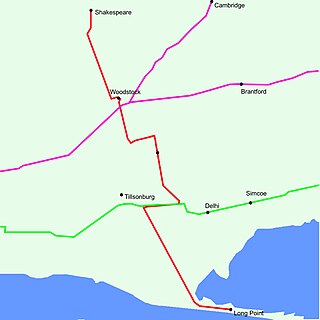
King's Highway 59, commonly referred to as Highway 59, was a provincially maintained highway in the Canadian province of Ontario. It connected Long Point Provincial Park in Norfolk County to the town of Shakespeare in Perth County, passing through the city of Woodstock in Oxford County en route. Several smaller towns also lined the highway, notably Courtland, Delhi, Norwich and Tavistock. Highway 59 featured junctions with Highway 3, Highway 2, Norfolk County Highway 24 and the concurrent routes of Highway 7 and Highway 8. Highway 59 also had an interchange with Highway 401.
Alberta Provincial Highway No. 16X, commonly referred to as Highway 16X, is the designation of one former and three proposed routes off Highway 16 in Alberta, Canada. The former section was a 36 km (22 mi) east–west provincial highway in Edmonton Capital Region, that existed for approximately 20 years between the 1970s and 1997 and is now part of Highway 16. Right of way is set aside around Hinton, Edson, and Lloydminster that is presently designated as Highway 16X.
Gulu–Nimule Road is a road in the Northern Region of Uganda, connecting the city of Gulu in Gulu District and the town of Nimule in Eastern Equatoria State in South Sudan, just north of the international border between the two countries. The road, known as Highway A104 in Uganda, continues into South Sudan as Highway A43.
Secondary Highway 501, commonly referred to as Highway 501, was a provincially maintained secondary highway in the Canadian province of Ontario. The highway was 13.1 kilometres (8.1 mi) long, connecting Highway 103 north of Port Severn with Honey Harbour.

C11 is a highway in southern Namibia. It starts along the C17 road, 129 kilometres (80 mi) from Keetmanshoop and finishes 319 kilometres (198 mi) later when it reaches the B3 road, two kilometres (1.2 mi) from Karasburg.
The Kampala–Mpigi Expressway, also Busega–Mpigi Expressway, is a proposed four-lane, dual carriage highway in the Central Region of Uganda, connecting, Kampala, the capital city, and Mpigi, the headquarters of Mpigi District.
R3 Highway is a primary road in Zimbabwe from the capital city Harare to Chirundu.


