C39 road (Namibia)

Last updated

Schild C39 NA.svg

C39 road
Highway system
Transport in Namibia
The road at Springbok Gate Springbok Gate.jpg
The road at Springbok Gate

C39 is an untarred road in central Namibia. It is 460 kilometres long and connects Torra Bay to Otavi. At Otavi the road connects with the B1 to Tsumeb and Windhoek and the B8 to Rundu.

Namibia republic in southern Africa

Namibia, officially the Republic of Namibia, is a country in southern Africa. Its western border is the Atlantic Ocean; it shares land borders with Zambia and Angola to the north, Botswana to the east and South Africa to the south and east. Although it does not border Zimbabwe, less than 200 metres of the Zambezi River separates the two countries. Namibia gained independence from South Africa on 21 March 1990, following the Namibian War of Independence. Its capital and largest city is Windhoek, and it is a member state of the United Nations (UN), the Southern African Development Community (SADC), the African Union (AU), and the Commonwealth of Nations.

Otavi Town in Otjozondjupa Region, Namibia

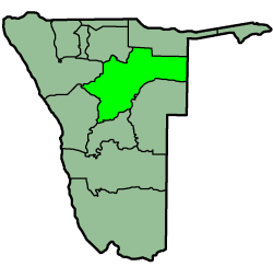
Otavi is a town of 4,000 inhabitants in the Otjozondjupa Region of central Namibia. Situated 360km north of Windhoek, it is the district capital of the Otavi electoral constituency. Most of the area is dolomitic (Precambrian) and the district was in the past renowned for its mineral wealth. Most of the deposits have now been exhausted.

B1 road (Namibia) road in Namibia

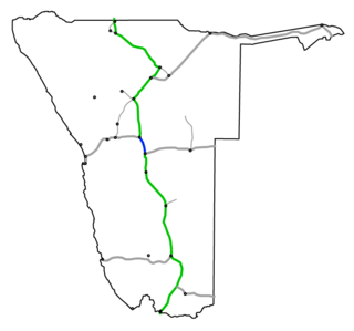
B1 is one of the most important roads in Namibia, passing through the centre of the country in a north-south direction. It connects Noordoewer on the South African border with Oshikango in the north on the Angolan border. Important cities it passes through in a North-South direction include Oshikango, Ondangwa, Tsumeb, Otavi, Otjiwarongo, Okahandja, Windhoek, Rehoboth, Mariental, Keetmanshoop and Noordoewer.


Related Research Articles

This article deals with the system of transport in Namibia, both public and private.

Otjozondjupa Region Region in Namibia

Otjozondjupa region is one of the fourteen regions of Namibia, whose capital is Otjiwarongo. An outstanding landmark within this region is the Waterberg Plateau Park. Administration offices are based in Otjiwarongo which is the largest town in the region.

Grootfontein Town in Otjozondjupa Region, Namibia

Grootfontein is a city of 23,793 inhabitants in the Otjozondjupa Region of central Namibia. It is one of the three towns in the Otavi Triangle, situated on the B8 national road that leads from Otavi to the Caprivi Strip.

Tsumeb Town in Oshikoto Region, Namibia

Tsumeb is a city of 15,000 inhabitants and the largest town in Oshikoto region in northern Namibia. Tsumeb is the "gateway to the north" of Namibia. It is the closest town to the Etosha National Park. Tsumeb used to be the regional capital of Oshikoto until 2008 when Omuthiya was proclaimed a town and the new capital. The area around Tsumeb forms its own electoral constituency and has a population of 44,113. The town is the site of a deep mine, that in its heyday was known simply as "The Tsumeb Mine" but has since been renamed the Ongopolo Mine.

The following lists events that happened during 1922 in South Africa.

The following lists events that happened during 1931 in South Africa.

Otjiwarongo City in Otjozondjupa Region, Namibia

Otjiwarongo is a city of 28,000 inhabitants in the Otjozondjupa Region of Namibia. It is the district capital of the Otjiwarongo electoral constituency and also the capital of Otjozondjupa.

Kongola Settlement in Zambezi Region, Namibia

Kongola is a settlement in Namibia's Caprivi Strip and the district capital of Kongola Constituency in the Zambezi Region. It is situated on the national road B8. Kongola has a petrol station and a wholesaler. Although the village is situated on a national power line, it has not yet been connected to the electricity grid. There is also no access to safe water at Kongola.

Usakos City in Erongo Region, Namibia

Usakos is a town on the banks of river Khan, 140 kilometres north-east of Swakopmund in the Erongo Region of Namibia. It is located on the B2, the main road between the Walvis Bay and Johannesburg. The town has 3,000 inhabitants and owns 58 square kilometres (22 sq mi) of land.

South African Class NG15 2-8-2 class of South African narrow-gauge 2-8-2 locomotives

The South African Railways Class NG15 2-8-2 of 1931 was a narrow-gauge steam locomotive.

B8 road (Namibia) road in Namibia

B8 road often known as the Golden Highway is one of the national highways of Namibia. It leads from the B1 at Otavi via Grootfontein and Rundu through the Caprivi Strip to the border town of Katima Mulilo and further on to the Botswanan border at Ngoma.

Omaruru railway station is a railway station serving the town of Omaruru in Namibia. It is part of the TransNamib railway network.

Rail transport in Namibia National Railways Of Namibia

Rail service in Namibia is provided by TransNamib. Namibia's rail network consists of 2,382 route-km of tracks, however this number continues to increase as the rail infrastructure continues to grow.

South West African Class Ha

The South West African Class Ha 0-6-2T of 1904 was a steam locomotive from the German South West Africa era.

South West African Class Hb class of 15 Nammibian 0-6-2 locomotives

The South West African Class Hb 0-6-2T of 1905 was a narrow gauge steam locomotive from the German South West Africa era.

South West African Class Hc

The South West African Class Hc 0-6-0T of 1907 was a narrow gauge steam locomotive from the German South West Africa era.

South West African Jung

The South West African Jung 0-6-2T of 1904 was a narrow gauge steam locomotive from the German South West Africa era.

Otavi railway station is located in the mining town of Otavi in north central Otjozondjupa Region Namibia.