Hardap is one of the fourteen regions of Namibia, its capital is Mariental. Hardap contains the municipality of Mariental, the towns Rehoboth and Aranos, and the self-governed villages Gibeon, Gochas, Kalkrand, Stampriet and Maltahöhe. It is home to the Hardap Dam.

Kasane is a town in Botswana, close to Africa's 'Four Corners', where the borders of Botswana, Namibia, Zambia and Zimbabwe almost meet. The town is at the far northeastern corner of Botswana where it serves as the administrative center of the Chobe District. The population of Kasane was 9,244 at the 2011 census.

Maltahöhe is a village in southern central Namibia close to the Swartrand escarpment, about 110 km west of Mariental in the Hardap Region. It has about 6,000 inhabitants and owns about 17,000 hectares of land. Maltahöhe has two suburbs, the Andreville location and the Blikkiesdorp informal settlement which has neither sewerage nor electricity supply.

TransNamib Holdings Limited, commonly referred to as TransNamib, is a state-owned railway company in Namibia. Organised as a holding company, it provides both rail and road freight services, as well as passenger rail services. Its headquarters are in the country’s capital Windhoek.

Solitaire is a small settlement in the Khomas Region of central Namibia near the Namib-Naukluft National Park. It currently features the only gasoline station, bakery, cafe, and the only general dealer between the dunes at Sossusvlei and the coast at Walvis Bay, as well as on the road to the capital Windhoek. Solitaire belongs to the Windhoek Rural electoral constituency.

Vehicle registration plates of Namibia are yellow fluorescent metal plates with imprints in black. The standard version is uniform throughout the country, and carries one of the following forms:
List of Railway stations in Botswana include:

B2 is a major road in Namibia. The highway runs east–west between the major sea port of Walvis Bay and the nation's capital Windhoek.

Spreetshoogte Pass is a mountain pass in central Namibia, connecting the Namib Desert with the Khomas Highland by traversing the Great Escarpment, a geological feature of much of the southern part of the African continent. With gradients between 1:4.5 and 1:6 it is the steepest pass in Namibia, as well as the one straddling the biggest elevation difference, descending from an altitude of 1,822 metres (5,978 ft) almost 1,000 metres (3,300 ft) within 4 kilometres (2.5 mi) of road. The top of the pass features a rest place from which there are views into the adjacent Namib.

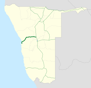
The C14, also the MR 36, is an untarred road in Namibia. It starts in Walvis Bay and goes south-east through Solitaire, Maltahöhe, Helmeringhausen and ends in Goageb. It is 643 kilometres (400 mi) long and rises up to an altitude of 1,528 metres (5,013 ft) above sea level. The steepest gradient is 1:9.

The Tsaris Pass is a mountain pass in the Hardap Region of central Namibia. It is situated west of Maltahöhe on the C19 road through the Tsaris Mountains in the Namib Desert in the direction of Sossusvlei, Sesriem, and Solitaire. Although the road has a grade of 1:18, it is unsuitable for trailers. This section of the C19 frequently is in bad condition. Tourists are advised not to attempt it without a 4x4.
The C44 is a gravel road in the Otjozondjupa Region of central Namibia. Its north-western terminus is at the B8 57 km (35 mi) north of Grootfontein. The C44 is 321 kilometres (199 mi) long and runs through Tsumkwe to Gam. It provides access to the Khaudom National Park via the D3315 turnoff in Tsumkwe, and to the Dobe border post with Botswana via the M74 east of Tsumkwe.
The C20 is a tarred highway in southern Namibia. It starts north of Mariental and ends in Gobabis. The highway is 320 kilometres (200 mi) long. The road travels eastwards past Stampriet to the C25 near Aranos and then north via Leonardville to Gobabis.
C21 is a secondary route in Namibia that runs from Maltahöhe to Hoachanas via Kalkrand. It is 173 kilometres (107 mi) long.

The C26 is a secondary route in Namibia that runs from south-central Windhoek, at the B1 road junction, to the Namib-Naukluft National Park. It is 192 kilometres (119 mi) long and terminates at the C14 road near farm Rostock. It provides an alternative route from the capital to Walvis Bay but is untarred outside Windhoek. For tourists travel by 4x4 is recommended. 30 kilometres (19 mi) outside Windhoek is the Kupferberg Pass at a maximum elevation of 2,050 metres (6,730 ft). About halfway the C26 leads further through the Gamsberg Pass, descending from an elevation of 1,867 metres (6,125 ft) into the Namib desert.
The C27 is a secondary route in Namibia that runs from Sesriem, in the Namib, to the C13 junction near Helmeringhausen. It is 237 kilometres (147 mi) long and rises up to an altitude of 1,717 metres (5,633 ft) above sea level.
The C35, also the MR 76, is a regional road in Namibia that runs from Henties Bay at the Atlantic Ocean up to the Angolan-Namibian border in Ruacana. It is 620 kilometres (390 mi) long. It has been described as one of Namibia's "most desolate roads".
The C36 is a secondary route in the Erongo Region of central Namibia. It runs from Wilhelmstal via Omaruru to Uis and is 196 kilometres (122 mi) long. Before the designation as a C road, the section between Wilhelmstal and Omaruru was the trunk road TR 7/2, and the section between Omaruru and Uis was the main road MR 64.
The C43 is a secondary route in Namibia that begins in Bergsig, running for 457 kilometres (284 mi) to the Angolan-Namibian border where it terminates at the Epupa Falls.
The C40 is a secondary route in central Namibia. It is 259 kilometres (161 mi) long, leading from Outjo via Kamanjab to Palmwag.


