 | ||||
|---|---|---|---|---|
| Major junctions | ||||
| North-West end | ||||
| South-East end | ||||
| Highway system | ||||
| ||||
C33 is a secondary route that runs from the B1 road near Otjiwarongo, travelling south-east to the B2 at Karibib.
| | ||||
|---|---|---|---|---|
| Major junctions | ||||
| North-West end | ||||
| South-East end | ||||
| Highway system | ||||
| ||||
C33 is a secondary route that runs from the B1 road near Otjiwarongo, travelling south-east to the B2 at Karibib.
Interstate 705 is a short Interstate Highway that is spur route of I-5 located entirely within Tacoma, Washington, United States. The freeway serves as the connector between I-5, Downtown Tacoma, Tacoma's waterfront, North Tacoma, and the Tacoma Dome. I-705 was the last new portion of the Interstate Highway System to be constructed in Washington, having opened in 1988.
State Route 7 (SR 7), formerly known as Inter-county Highway 7 until 1921 and State Highway 7 in 1922, is a north–south state highway in the southern and eastern portions of the U.S. state of Ohio. At about 336 miles (541 km) in length, it is the longest state route in Ohio. Its southern terminus is an interchange with U.S. Route 52 (US 52) just west of Chesapeake. Its northern terminus also serves as the eastern terminus of SR 531 in Conneaut. The path of SR 7 stays within five miles (8.0 km) of the Ohio River for the southern portion, with the river being visible from much of the route. The road also remains within 10 miles (16 km) of the Pennsylvania state line for the northern portion.
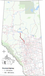
Alberta Provincial Highway No. 33, commonly referred to as Highway 33 and officially named Grizzly Trail, is a north–south highway in west–central Alberta, Canada.

This is a list of the National Register of Historic Places listings in Randolph County, West Virginia.
Secondary Highway 533, commonly referred to as Highway 533, is a provincially maintained secondary highway in the Canadian province of Ontario. The route begins in the town of Mattawa, at Highway 17, and travels north to Highway 63. Between these two junctions is a large barren expanse of wilderness with almost no habitation. Mattawa is the only community along the route. Highway 533 was assumed in 1956, along with many of the secondary highways in the province. It was later extended to Highway 63 in 1958, establishing the route as it remains today. A roundabout with Highway 17 was opened in late 2011, the first on a provincial highway in Ontario.
St. Lawrence University (Uganda) (SLAU) is a private university in Uganda.
The Kampala Northern Bypass Highway, often referred to as the Northern Bypass, is a road in Uganda. It forms a semicircle across the northern suburbs of Kampala, Uganda's capital and largest city. The road was constructed to relieve traffic congestion within the city center, allowing cross-country traffic to bypass the city's downtown area.
C24 is a secondary route in Namibia that runs from the southern outskirts of Rehoboth.
C26 is a secondary route in Namibia that runs from south-central Windhoek, at the B1 road junction, to the C14 road near Rostock.
C29 is a secondary route in Namibia that runs from the south, at the B6 junction approximately 65 miles east of Windhoek. The C29 then terminates to the north at the C22 junction near Otjinene.
The C31 is a secondary route in Namibia that runs from the Okahandja at the B1 junction up north-westerly to Summerdown, Omaheke, where it meets the C29.
C32 is a secondary route in Namibia that runs from Karibib in the north to the C28 junction in the south, near the Tsaobis Nature Park.
C30 is a secondary route in Namibia that runs from the C22 near Otjiwarongo and Okakarara, where it meets the B6 in Gobabis.
C36 is a secondary route in Namibia that runs from the B2 at Wilhelmstal. It is intersected by the C33 at Omaruru before terminating at Uis, where it joins the C35. The C36 is paved.
C37 is a short secondary route in southern Namibia, near the South African border. Alternatively the C37 is referred to as the D207.
C38 is a secondary route that runs from Otjiwarongo in the south, through Outjo at its intersection with the C39.
C46 is a secondary route in northern Namibia that runs from Ruacana, near the border with Angola, to the B1 trunk road at Ondangwa.
| Freeways | ||
|---|---|---|
| Trunk routes | ||
| Secondary routes | ||
| International routes | ||