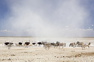
Etosha National Park is a national park in northwestern Namibia and one of the largest national parks in Africa. It was proclaimed a game reserve in March 1907 in Ordinance 88 by the Governor of German South West Africa, Friedrich von Lindequist. It was designated as Wildschutzgebiet in 1958, and was elevated to the status of a national park in 1967 by an act of parliament of the Republic of South Africa. It spans an area of 22,270 km2 (8,600 sq mi) and gets its name from the large Etosha pan which is almost entirely within the park. With an area of 4,760 km2 (1,840 sq mi), the Etosha pan covers 23% of the total area of the national park. The area is home to hundreds of species of mammals, birds and reptiles, including several threatened and endangered species such as the black rhinoceros.
Illinois Route 38 is a 88.86-mile-long (143.01 km) west–east state highway that runs across northern Illinois. It runs from U.S. Route 52 (US 52) in downtown Dixon to US 12/US 20/US 45 in Westchester. It runs concurrently with the Lincoln Highway between Dixon and the junction of Illinois Route 31 in Geneva where it transitions via State Street onto Roosevelt Road at the junction of Kirk Road and continues through the western suburbs to its terminus at the junction of Mannheim Road. Roosevelt Road continues on an additional 14 miles without a route designation until terminating at US 41.
H-58 is a county-designated highway in the US state of Michigan that runs east–west for approximately 69 miles (111 km) between the communities of Munising and Deer Park in the Upper Peninsula. The western section is routed through Pictured Rocks National Lakeshore, along the southern shore of Lake Superior, and the adjacent Lake Superior State Forest in Alger County while connecting Munising to the communities of Van Meer and Melstrand. At Grand Marais, H-58 exits the national lakeshore area and runs through town. The segment running east of Grand Marais to Deer Park in Luce County is a gravel road that connects to H-37 in Muskallonge Lake State Park.

Angolan mopane woodlands are situated in southwestern Angola, extending into northern Namibia. This ecosystem surrounds Etosha Pan, which is considered a separate ecoregion. The mopane trees are the main type of vegetation.

Tsumeb Airport is an airport serving Tsumeb, a town in the Oshikoto Region of Namibia. The airport is just east of the town. Tsumeb is the location of a former mining operation and is the closest town to the Etosha National Park.
Halali Airport is an airport serving the resort of Halali, in the Oshikoto Region of Namibia. The resort is near some of the waterholes of the Etosha National Park, and has elevated viewing platforms for observing native wildlife like elephants, rhinoceros, and leopards.
Mokuti Lodge Airport is an airport serving Mokuti Lodge resort and the Etosha National Park in Namibia.
Namutoni Airport is an airport serving Namutoni and the Etosha National Park in Namibia. Namutoni is an entrance gate to the park.
Okaukuejo Airport is an airport in the Oshana Region of Namibia, serving the Etosha National Park and its administrative center, Okaukuejo. The runways are 3 kilometres (1.9 mi) north of the village.
Otavi railway station is located in the mining town of Otavi in Namibia's central Otjozondjupa Region. It is served by a mostly freight railway and limited number of passenger service. The extension of the railway towards the east to Grootfontein is exclusively for freight service.
C32 is a secondary route in Namibia that runs from Karibib in the north to the C28 junction in the south, near the Tsaobis Nature Park.
C34 is a secondary route in Namibia that runs from the B2 in Swakopmund city centre, travelling up the coast of the Namib Desert and the Skeleton Coast.
C35 is a secondary route in Namibia that runs from C34 in Henties Bay, up to the Angolan-Namibian border in Ruacana.
C36 is a secondary route in Namibia that runs from the B2 at Wilhelmstal. It is intersected by the C33 at Omaruru before terminating at Uis, where it joins the C35. The C36 is paved.
C40 is a secondary route that runs from the C38 junction near Outjo in the west, terminating at the C43 junction at Palmwag.
C41 is a secondary route in Namibia that runs from Outapi to Oshakati. The C41 diverges from C46, the direct route between Outapi to Oshakati, to incorporate the villages of Tsandi and Okahao.
C42 is a secondary route in Namibia that runs from Grootfontein, Otjozondjupa Region to Tsumeb, Oshikoto Region.
C46 is a secondary route in northern Namibia that runs from Ruacana, near the border with Angola, to the B1 trunk road at Ondangwa.
C47 is a secondary route in Namibia that runs from Okakarara to the abandoned Otjituuo airfield in the Otjozondjupa Region.
