
Interstate 37 (I-37) is a 143-mile (230 km) Interstate Highway located within the southern portion of the US state of Texas. The highway was first designated in 1959 as a route between Corpus Christi and San Antonio. Construction in the urban areas of Corpus Christi and San Antonio began in the 1960s, and the segments of the Interstate Highway in rural areas were completed by the 1980s. Prior to I-37, the route between Corpus Christi and San Antonio was served by a combination of State Highway 9 (SH 9) from Corpus Christi to Three Rivers and U.S. Highway 281 (US 281) from Three Rivers to San Antonio. As a result of the construction of I-37, SH 9 was removed from the State Highway System.

State Route 2, formerly known as Inter-county Highway 2 until 1921 and State Highway 2 in 1922, is an east–west highway crossing most of northern Ohio. Its western terminus is at the Indiana state line near Hicksville where the route becomes Indiana State Road 37 which continues to Fort Wayne, Indiana. The eastern terminus of the route is in Painesville Township in Lake County at U.S. Route 20 (US 20).

Google Maps is a web mapping platform and consumer application offered by Google. It offers satellite imagery, aerial photography, street maps, 360° interactive panoramic views of streets, real-time traffic conditions, and route planning for traveling by foot, car, bike, air and public transportation. As of 2020, Google Maps was being used by over 1 billion people every month around the world.
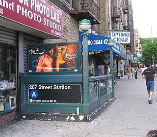
The Inwood–207th Street station is the northern terminal station of the IND Eighth Avenue Line of the New York City Subway. Located at the intersection of 207th Street and Broadway in the Manhattan neighborhood of Inwood, near Inwood Hill Park, it is served by the A train at all times.

The Dyckman Street station is a station on the IND Eighth Avenue Line of the New York City Subway, located at the intersection of Dyckman Street and Broadway in Inwood, within northern Manhattan. It is served by the A train at all times.
M-44 is a 37.463-mile (60.291 km) state trunkline highway in the western region of the US state of Michigan. It runs northward from the intersection of M-11 and M-37 toward the Rockford area. The highway then turns eastward to Belding, and it ends six miles (10 km) north of Ionia at M-66. M-44 is known in Grand Rapids as the "East Beltline" and intersects with its related highway, Connector M-44, in Plainfield Township. This highway runs concurrently with M-37 between M-11 and Interstate 96 (I-96).

The 116th Street station is a local station on the IND Eighth Avenue Line of the New York City Subway. Located at the intersection of 116th Street and 8th Avenue in Harlem, Manhattan, it is served by the B train on weekdays, the C train at all times except nights, and the A train during late nights only.
New York State Route 37 (NY 37) is a state highway in the North Country of New York in the United States, extending for 127.40 miles (205.03 km) on a west–east axis. The western terminus of the route is at an intersection with U.S. Route 11 (US 11) in Pamelia, Jefferson County. Its eastern terminus is at a junction with US 11, NY 11B, and NY 30 in Malone, Franklin County. In between the termini, NY 37 passes through Ogdensburg and Massena. It is a two-lane, nondivided, full access roadway for most of its entire length, except for portions between Massena and western Franklin County, where the route widens to a four-lane divided highway.
King's Highway 37, commonly referred to as Highway 37, is a provincially maintained highway in the Canadian province of Ontario. It begins at Highway 401 in Belleville and travels 44.2 km (27.5 mi) north to Highway 7 in Actinolite. The route once continued south through Belleville to Highway 62, but was truncated in 1998. Prior to the re-routing, Highway 37 was 47.2 km (29.3 mi) long.

State Route 174 (SR 174) is a 40.66-mile (65.44 km) long state highway that traverses Douglas, Grant and Lincoln counties in Washington. SR 174 begins at a junction with SR 17 in Leahy and travels eastward to Grand Coulee, near the Grand Coulee Dam, to intersect SR 155. From Grand Coulee, the roadway travels southeast to end at SR 21 northwest of Wilbur.

State Route 207 (SR 207) is a 4.38-mile-long (7.05 km) state highway serving Wenatchee National Forest and Lake Wenatchee State Park in Chelan County, located within the U.S. state of Washington. The highway travels north along Nason Creek from an intersection with U.S. Route 2 (US 2) at Coles Corner to Chiwawa Loop Road on the eastern shore of Lake Wenatchee. SR 207 was previously signed as part of Secondary State Highway 15C (SSH 15C) and SSH 15D until the 1964 highway renumbering, when SSH 15C was split between SR 207 and SR 209. SR 209 was removed from the highway system in 1991 and SR 207 was shortened to end at the former terminus of SR 209.
Federal Highway 37 is a free part of the federal highways corridors of Mexico. The highway runs from Villa de Zaragoza, San Luis Potosí at its northern point to Playa Azul, Michoacán, located near the Pacific Ocean, at its southern point, near the port city of Lázaro Cárdenas, Michoacán. It crosses Fed. 14 at Uruapan, Michoacán, and Mexican Federal Highway 200 at La Mira, Michoacan.
C24 is a secondary route in Namibia that runs from the southern outskirts of Rehoboth.
C30 is a secondary route in Namibia that runs from the C22 near Otjiwarongo and Okakarara, where it meets the B6 in Gobabis.
C38 is a secondary route that runs from Otjiwarongo in the south, through Outjo at its intersection with the C39.
C40 is a secondary route that runs from the C38 junction near Outjo in the west, terminating at the C43 junction at Palmwag.
C46 is a secondary route in northern Namibia that runs from Ruacana, near the border with Angola, to the B1 trunk road at Ondangwa.
