
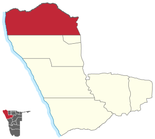
Kunene is one of the fourteen regions of Namibia. Its capital is Opuwo, its governor is Marius Sheya. The region's name comes from the Kunene River which forms the northern border with Angola. Besides the capital Opuwo, the region contains the municipality of Outjo, the town Khorixas and the self-governed village Kamanjab. Kunene is home to the Himba people, a subtribe of the Herero. As of 2020, Kunene had 58,548 registered voters.

The Cunene or Kunene is a river in Southern Africa. It flows from the Angola highlands south to the border with Namibia. It then flows west along the border until it reaches the Atlantic Ocean. It is one of the few perennial rivers in the region. It is about 1,050 kilometres (652 mi) long, with a drainage basin 106,560 square kilometres (41,143 sq mi) in area. Its mean annual discharge is 174 m3/s at its mouth. The Epupa Falls lie on the river. Olushandja Dam dams a tributary of the river, the Etaka, and helps provide the Ruacana Power Station with water.
Kaokoland was an administrative unit and a bantustan in northern South West Africa. Established during the apartheid era, it was intended to be a self-governing homeland of the OvaHimba, but an actual government was never established. Like other homelands in South West Africa, the Kaokoland bantustan was abolished in May 1989, at the beginning of the transition of Namibia towards independence. "Kaokoland" remains as an informal name for the geographic area, while the political unit of administration since 1990 is Kunene Region. The area is in the Kaokoveld ecoregion.
Epupa is a constituency in the Kunene Region of Namibia. Its population in 2004 was 12,816. As of 2020, it has 12,182 registered voters.

Epupa Falls is a series of large waterfalls created by the Cunene River on the border of Angola and Namibia, in the Kaokoland area of the Kunene Region. The river is about 0.5 kilometres (1,600 ft) wide in this area and drops in a series of waterfalls across a length of 1.5 kilometres (0.93 mi), with the greatest single drop being 37 metres (121 ft) in height. The settlement near the falls is also called Epupa.
Articles related to Namibia include:
The Ruacana Hydroelectric Power Station is a hydroelectric power plant near Ruacana in northwest Namibia, close to the Angolan border. Commissioned in 1978, it is by far the largest power station in Namibia. Its operator is NamPower, the Namibian national electric power utility company.

Swartbooisdrift is a small settlement in Kunene Region in the north of Namibia. It is situated on the banks of the Kunene River, directly at the Angolan border on the minor road D3700 and falls within the Epupa electoral constituency. Swartbooisdrift is populated by 150 - 300 semi-nomadic people of Himba and Herero descent, depending on the season.
C24 is a secondary route in Namibia that runs from the southern outskirts of Rehoboth.
C26 is a secondary route in Namibia that runs from south-central Windhoek, at the B1 road junction, to the C14 road near Rostock.
C29 is a secondary route in Namibia that runs from the south, at the B6 junction approximately 65 miles east of Windhoek. The C29 then terminates to the north at the C22 junction near Otjinene.
The C31 is a secondary route in Namibia that runs from the Okahandja at the B1 junction up north-westerly to Summerdown, Omaheke, where it meets the C29.
C30 is a secondary route in Namibia that runs from the C22 near Otjiwarongo and Okakarara, where it meets the B6 in Gobabis.
C35 is a secondary route in Namibia that runs from C34 in Henties Bay, up to the Angolan-Namibian border in Ruacana.
C36 is a secondary route in Namibia that runs from the B2 at Wilhelmstal. It is intersected by the C33 at Omaruru before terminating at Uis, where it joins the C35. The C36 is paved.
C41 is a secondary route in Namibia that runs from Outapi to Oshakati. The C41 diverges from C46, the direct route between Outapi to Oshakati, to incorporate the villages of Tsandi and Okahao.
C46 is a secondary route in northern Namibia that runs from Ruacana, near the border with Angola, to the B1 trunk road at Ondangwa.
C48 is a short secondary route in the Caprivi Strip, Namibia. It terminates at Divundu in the north, and at the Botswanan-Namibian border in the south.
C49 is a secondary route in the Caprivi Strip in Namibia, which leaves and rejoins the B8, at Katima Mulilo and Kongola, respectively.
