 | ||||
|---|---|---|---|---|
| Major junctions | ||||
| East end | ||||
| West end | ||||
| Highway system | ||||
| ||||
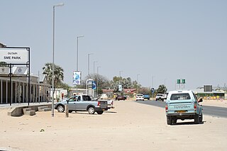
C46 is a secondary route in northern Namibia that runs from Ruacana, near the border with Angola, to the B1 trunk road at Ondangwa. [1]
| | ||||
|---|---|---|---|---|
| Major junctions | ||||
| East end | ||||
| West end | ||||
| Highway system | ||||
| ||||
C46 is a secondary route in northern Namibia that runs from Ruacana, near the border with Angola, to the B1 trunk road at Ondangwa. [1]

Omusati is one of the fourteen regions of Namibia, its capital is Outapi. The towns of Okahao, Oshikuku and Ruacana as well as the self-governed village Tsandi are situated in this region. As of 2020, Omusati had 148,834 registered voters.
Outapi wa Nakafingo na Temba, also Outapi or Uutapi and Ombalantu, is a town in northern Namibia near the border with Angola situated 90 km (56 mi) northwest of Oshakati. It is the capital of Omusati region and the district capital of the Outapi electoral constituency. The language spoken there is Oshiwambo.
Tsandi is a village in the Omusati Region of northern Namibia and the district capital of the Tsandi electoral constituency. It is a former mission station of the Finnish Missionary Society. It is situated on the main road MR123.

Outapi Constituency is an electoral constituency in the Omusati Region of Namibia on the border of Angola. It had 30,313 inhabitants in 2004 and 23,516 registered voters in 2020. Its district capital is the town of Outapi.

The Ombalantu baobab tree, known also as a Tree of Life or Omukwa waaMbalantu, is a giant baobab tree of the species Adansonia digitata, situated in Outapi in the north of Namibia on the Main Road 123 from Tsandi. It is 28 metres (92 ft) tall, 26.5 metres (87 ft) in circumference, and estimated to be 800 years old.
C10 is an untarred highway in southern Namibia. It starts in ǀAi-ǀAis and ends at the Namibia–South Africa border where the road changes into the R358 road at Onseepkans. The highway is 241 kilometres (150 mi) long. The road travels one kilometre (0.62 mi) past from Karasburg, which can be accessed by the M21. This also can be used to get onto the B3 road.
C11 is an untarred highway in southern Namibia. It starts along the C17 road, 129 kilometres (80 mi) from Keetmanshoop and finishes 319 kilometres (198 mi) later when it reaches the B3 road, two kilometres (1.2 mi) from Karasburg.

The A1 is a national highway in Namibia. The 76 kilometres (47 mi) stretch of road between Windhoek and Okahandja is the only A-rated road in Namibia. Consisting of freeway for its entire length, it came into existence in 2017 when freeway sections of the B1 were redesignated A1 in accordance with new standards of the Roads Authority Namibia. The entirety of the A1 forms part of the Trans-Kalahari Corridor and, together with the B1, also forms part of the Tripoli-Cape Town Highway.
C21 is a secondary route in Namibia that runs from Maltahöhe to Hoachanas via Kalkrand.
C24 is a secondary route in Namibia that runs from the southern outskirts of Rehoboth.
C26 is a secondary route in Namibia that runs from south-central Windhoek, at the B1 road junction, to the C14 road near Rostock.
C29 is a secondary route in Namibia that runs from the south, at the B6 junction approximately 65 miles east of Windhoek. The C29 then terminates to the north at the C22 junction near Otjinene.
The C31 is a secondary route in Namibia that runs from the Okahandja at the B1 junction up north-westerly to Summerdown, Omaheke, where it meets the C29.
C30 is a secondary route in Namibia that runs from the C22 near Otjiwarongo and Okakarara, where it meets the B6 in Gobabis.
C35 is a secondary route in Namibia that runs from C34 in Henties Bay, up to the Angolan-Namibian border in Ruacana.
C36 is a secondary route in Namibia that runs from the B2 at Wilhelmstal. It is intersected by the C33 at Omaruru before terminating at Uis, where it joins the C35. The C36 is paved.
C41 is a secondary route in Namibia that runs from Outapi to Oshakati. The C41 diverges from C46, the direct route between Outapi to Oshakati, to incorporate the villages of Tsandi and Okahao.
C43 is a secondary route in Namibia that begins in Bergsig, running for 457 kilometres to the Angolan-Namibian border where it terminates at Epupa Falls.
C48 is a short secondary route in the Caprivi Strip, Namibia. It terminates at Divundu in the north, and at the Botswanan-Namibian border in the south.
C49 is a secondary route in the Caprivi Strip in Namibia, which leaves and rejoins the B8, at Katima Mulilo and Kongola, respectively.
| Freeways | ||
|---|---|---|
| Trunk routes | ||
| Secondary routes | ||
| International routes | ||