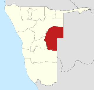
Omaheke is one of the fourteen regions of Namibia, the least populous region. Its capital is Gobabis. It lies in eastern Namibia on the border with Botswana and is the western extension of the Kalahari desert. The self-governed villages of Otjinene, Leonardville and Witvlei are situated in the region. As of 2020, Omaheke had 48,594 registered voters.
ǂKxʼaoǁʼae, or Gobabi ǃKung (Gobabis-ǃXû), is a southeastern dialect of the ǃKung language, spoken in Botswana and in Namibia by about 7,000 people. In Botswana, most speakers are bilingual in Naro or Tswana.

Gobabis is a city in eastern Namibia. It is the regional capital of the Omaheke Region, and the district capital of the Gobabis electoral constituency. Gobabis is situated 200 km (120 mi) down the B6 motorway from Windhoek to Botswana. The town is 113 km (70 mi) from the Buitepos border post with Botswana, and serves as an important link to South Africa on the tarred Trans-Kalahari Highway. Gobabis is in the heart of the cattle farming area. In fact Gobabis is so proud of its cattle farming that a statue of a large Brahman bull with the inscription "Cattle Country" greets visitors to the town. Gobabis also has its own local Airport.

The Gobabis Residents' Association (GRA) is a local political party in Gobabis, Namibia.

Windhoek railway station is a railway station serving the city of Windhoek, the capital of Namibia. It is an important station in the Namibian rail network, and it is run by TransNamib.
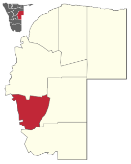
Gobabis Constituency is an electoral constituency in the Omaheke Region of Namibia. As of December 2019 it had 13,457 registered voters. The constituency covers the rural area southeast of Gobabis and the town itself, except its Nossobville suburb. Gobabis is also the administrative centre of the constituency.
Osire is a refugee camp in central Namibia, situated 200 km north of the capital Windhoek next to the main road C30 from Gobabis to Otjiwarongo. It was established in 1992 to accommodate refugees from Angola, Burundi, the Democratic Republic of the Congo, Rwanda and Somalia. The camp grew quickly in its early years, reaching a peak of 20,000 inhabitants in 1998. Since then the refugee population of Osire decreased steadily, approaching 6,500 in 2010, and 3,000 in 2014. Due to the cessation of conflicts in the countries where inhabitants originate from, the camp is scheduled to close. In 2008 the majority (75%) of refugees still resident here came from Angola, and a sizeable portion from the Democratic Republic of the Congo. UNHCR regards the camp as one of the best managed in the world, due to its provisioning of formal school education, both primary and secondary. The settlement further has a police station and a clinic.

Rail service in Namibia is provided by TransNamib. The Namibian rail network consists of 2,687 route-km of tracks (2017).

Gobabis Airport is an airport serving the town of Gobabis, Namibia. Airport elevation 4,729 feet (1,441 m). Runway 07/25 length: 2,265 metres (7,431 ft). Runway 11/29 length: 1,605 metres (5,266 ft). Both are gravel runways. Customs and Immigration on request.

Eiseb, also Eiseb Block, is a settlement in the Omaheke Region of Namibia. It is named after the Eiseb River, an ephemeral river (omuramba) in the Kalahari desert. Eiseb is situated on the District road D1635 c. 350 kilometres (220 mi) northeast of Talismanus and belongs to the Otjombinde electoral constituency.

Drimiopsis is a village in the Omaheke Region in Namibia, about 40 km north of Gobabis. The local population includes mainly San, Khoekhoe-speakers, Herero, and Tswana.
The Gobabis Reformed Church is a congregation of the Dutch Reformed Church in South Africa (NGK) in Gobabis in eastern Namibia. In 1961, the Gobabis-South daughter congregation was founded, which was reincorporated into the mother church on October 21, 2012, making Gobabis the seventh city in Namibia to have two NGK congregations.
C20 is a tarred highway in southern Namibia. It starts in Hardap and ends in Gobabis. The highway is 320 kilometres (200 mi) long. The road travels past Aranos and Stampriet.

The B14 is a national road in Namibia, running since 2018 from Gobabis to Grootfontein. A further expansion from Gobabis to Aranos in the south is planned.
C22 is a secondary route in Namibia that exists in two discontinuous sections: a southern section running from Aranos to Gobabis, and a northern section running from Okondjatu to Otjiwarongo. The section between Gobabis and Okondjatu, formerly part of the C22, is now part of the B14.
C25 is a secondary route in Namibia that runs from the northern B1 junction in Rehoboth to the C23 near Leonardville.
C26 is a secondary route in Namibia that runs from south-central Windhoek, at the B1 road junction, to the C14 road near Rostock.
C27 is a secondary route in Namibia that runs from Sesriem, in the Namib, to the C13 junction near Helmeringhausen.
C29 is a secondary route in Namibia that runs from the south, at the B6 junction approximately 65 miles east of Windhoek. The C29 then terminates to the north at the C22 junction near Otjinene.
C32 is a secondary route in Namibia that runs from Karibib in the north to the C28 junction in the south, near the Tsaobis Nature Park.
