Interstate 17 (I-17) is a north–south Interstate Highway located entirely within the U.S. state of Arizona. I-17's southern terminus lies within Phoenix, at Interstate 10, and its northern terminus is in Flagstaff, at Interstate 40. The majority of I-17 is known as the Arizona Veterans Highway. In the Phoenix metropolitan area, it is mostly known as the Black Canyon Freeway, however the southern 4.16 miles (6.69 km) is part of the Maricopa Freeway. The portion of the highway south of Cordes Lakes was built along the alignment of SR 69, while the northern part was built along old SR 79's alignment. I-17 is one of the most scenic Interstate Highways as it gains more than a mile in altitude between Phoenix at 1,117 feet (340 m) and Flagstaff at 7,000 feet (2,100 m). The highway features several scenic view exits along its route that overlook the many mountains and valleys found in northern Arizona.
Route 7 is a state highway in the northern part of New Jersey in the United States. It has two sections, an east–west alignment running from U.S. Route 1/9 Truck in Jersey City to Route 21 in Belleville, and a north–south alignment running from the Newark/Belleville to the Nutley/Clifton border. The New Jersey Department of Transportation (NJDOT) lists Route 7 as a single north–south highway with a small gap between the alignments. The entire highway has a combined length of 9.46 mi (15.22 km).
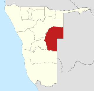
Omaheke is one of the fourteen regions of Namibia, its capital is Gobabis. It lies on the eastern border of Namibia and is the Western extension of the Kalahari desert. The name Omaheke is the Herero word for Sandveld.
M-15 is a north–south state trunkline highway in the US state of Michigan. The southern terminus is a junction with US Highway 24 (US 24) just south of Clarkston on the northwestern edge of the Detroit metropolitan area. The trunkline is a recreational route running north and northwest to the Tri-Cities area. The northern terminus is the junction with M-25 on the east side of Bay City. The total length is about 73 2⁄3 miles (118.6 km) between the two regions.
Interstate 540 (I-540) and North Carolina Highway 540 (NC 540) are part of a partially completed beltway around the city of Raleigh in the U.S. state of North Carolina forming the Raleigh Outer Loop. When complete, the route will completely encircle the city, meeting its parent route of Interstate 40 in one location.
New York State Route 22 (NY 22) is a north–south state highway that parallels the eastern border of the U.S. state of New York, from the outskirts of New York City to the hamlet of Mooers in Clinton County near the Canadian border. At 337 miles (542 km), it is the state's longest north–south route and the third longest state route overall, after NY 5 and NY 17. Many of the state's major east–west roads intersect with, and often join, NY 22 just before crossing into the neighboring New England states, where U.S. Route 7 (US 7), which originally partially followed NY 22's alignment, similarly parallels the New York state line.
State Road 907 (SR 907), also known as Alton Road and 63rd Street, is a major north–south artery in Miami Beach, Florida, USA, extending 5.659-mile (9.107 km). It is one of a few of the state roads that have both termini on the same state route. In this case, the southern terminus is the intersection of Alton Road and Fifth Street, and the northern terminus is the intersection of 63rd Street and Collins Avenue. Alton Road snakes up the western side of the barrier islands comprising Miami Beach, while Collins Avenue parallels the Atlantic shore to the east. In addition, SR 907 is often used as a bypass for the oft-congested SR A1A.

State Highway 74, usually abbreviated as SH-74 or OK-74 is the numbering of two different highways maintained by the U.S. state of Oklahoma. These highways were once a single major north–south route, connecting Oklahoma City to more rural parts of the state. The original road stretched from SH-7 near Tatums, Oklahoma to SH-11 west of Deer Creek.
State Trunk Highway 70 is a state highway in the U.S. state of Wisconsin. It runs east–west in northern Wisconsin from a shared terminus with WIS 101 at US Highway 2 (US 2) and US 141 near Florence to a connection with Minnesota State Highway 70 (MN 70) at the St. Croix River five miles (8.0 km) west of Grantsburg in Burnett County. It serves the communities of Grantsburg, Siren, Spooner, and the resort areas of Minocqua, Woodruff and Eagle River along its route. WIS 70 is the third-most northern route to almost completely cross Wisconsin, stretching from Minnesota to within four miles (6.4 km) of the Michigan border.
M-73 is a north–south state trunkline highway in the Upper Peninsula of the US state of Michigan. It connects with US Highway 2 (US 2) and Highway 55 (WIS 55) at the state line near Iron River. Running through forest, the highway was first designated along with the rest of the state highway system in 1919. Unchanged since its inception, M-73 was completely paved by the mid-1930s.
National Route 279 is a national highway of Japan that traverses the prefectures of Aomori and Hokkaido, as well as the Tsugaru Strait that separates them. The 134.0-kilometer (83.3 mi) highway begins at an intersection with National Route 5 in Hakodate, then crosses the Tsugaru Strait on a ferry from Hakodate to Ōma, Aomori, that it shares with National Route 279, where it then travels south through eastern Aomori Prefecture, passing through the city of Mutsu before ending at an intersection with National Route 4 in Noheji.
Route 134 is a 261 km (162 mi)-long north–south secondary highway in eastern New Brunswick, Canada. The highway is divided by into a northern and southern section by a gap in Northumberland County connected by Route 11 and Route 8.

.

Rail service in Namibia is provided by TransNamib. Namibias rail network consists of 2,687 route-km of tracks (2017).
C20 is a tarred highway in southern Namibia. It starts in Hardap and ends in Gobabis. The highway is 320 kilometres (200 mi) long. The road travels past Aranos and Stampriet.

Wesley Vale is a locality and town in the local government area of Latrobe on the North West coast of Tasmania, Australia. It is located approximately 10 km East of Devonport, and 10 km west of Port Sorell. The 2016 census determined a population of 443 for the state suburb of Wesley Vale.

The A1 is a national highway in Namibia. The 76 kilometres (47 mi) stretch of road between Windhoek and Okahandja is the only A-rated road in Namibia. Consisting of freeway for its entire length, it came into existence in 2017 when freeway sections of the B1 were redesignated A1 in accordance with new standards of the Roads Authority Namibia. The entirety of the A1 forms part of the Trans-Kalahari Corridor and, together with the B1, also forms part of the Tripoli-Cape Town Highway.
