Glenwood Springs is the Home Rule Municipality that is the county seat of Garfield County, Colorado, United States. Glenwood Springs is located at the confluence of the Roaring Fork River and the Colorado River, threading together the Roaring Fork Valley and a series of smaller towns up and down the Colorado River. As of the 2010 census it had a population of 9,614.

The Mojave River is an intermittent river in the eastern San Bernardino Mountains and the Mojave Desert in San Bernardino County, California, United States. Most of its flow is underground, while its surface channels remain dry most of the time, with the exception of the headwaters and several bedrock gorges in the lower reaches.
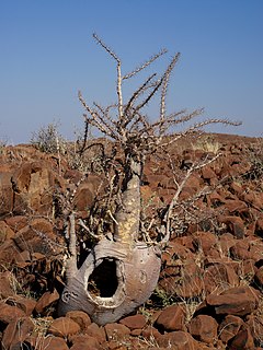
Pachypodium lealii, the bottle tree, is a species of plant included in the genusPachypodium. The scientific name derives from the 19th century Portuguese geologist Fernando da Costa Leal, who described the bottle tree during an exploration in southern Angola.
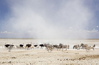
Etosha National Park is a national park in northwestern Namibia. It was proclaimed a game reserve in March 1907 in Ordinance 88 by the Governor of German South West Africa, Dr. Friedrich von Lindequist. It was designated as Wildschutzgebiet in 1958, and was elevated to the status of a national park in 1967 by an act of parliament of the Republic of South Africa. It spans an area of 22,270 km2 (8,600 sq mi) and gets its name from the large Etosha pan which is almost entirely within the park. The Etosha pan covers 23% of the total area of the National Park. The park is home to hundreds of species of mammals, birds and reptiles, including several threatened and endangered species such as the black rhinoceros.
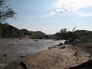
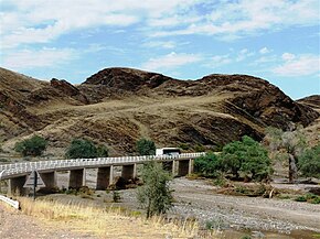
The Kuiseb River is an ephemeral river in western-central Namibia. Its source is in the Khomas Highland west of Windhoek. From there it flows westwards through the Namib-Naukluft National Park and the Namib desert to Walvis Bay. Several settlements of the Topnaar people are situated on the banks of the lower Kuiseb, for instance Homeb, Sandfontein, Rooibank, and Utuseb. Inflows of the Kuiseb are Gomab, Ojab, Chausib, Gaub, Koam, Nausgomab and Goagos.

The ǁKaras Region is the southernmost and least densely populated of the 14 regions of Namibia; its capital is Keetmanshoop. The name assigned to the region reflects the prominence of the Karas mountain range in its southern part. The ǁKaras region contains the municipality of Keetmanshoop, the towns Karasburg, Lüderitz and Oranjemund, and the self-governed villages Aroab, Berseba, Bethanie, Koës and Tses.

The Fish River Canyon, is located in the south of Namibia. It is the largest canyon in Africa, as well as the second most visited tourist attraction in Namibia. It features a gigantic ravine, in total about 100 miles (160 km) long, up to 27 km wide and in places almost 550 meters deep.

The Fraser Canyon is a major landform of the Fraser River where it descends rapidly through narrow rock gorges in the Coast Mountains en route from the Interior Plateau of British Columbia to the Fraser Valley. Colloquially, the term "Fraser Canyon" is often used to include the Thompson Canyon from Lytton to Ashcroft, since they form the same highway route which most people are familiar with, although it is actually reckoned to begin above Williams Lake, British Columbia at Soda Creek Canyon near the town of the same name.

The Douglas Road, a.k.a. the Lillooet Trail, Harrison Trail or Lakes Route, was a goldrush-era transportation route from the British Columbia Coast to the Interior. Over 30,000 men are reckoned to have travelled the route in, although by the end of the 1860s it was virtually abandoned due to the construction of the Cariboo Wagon Road, which bypassed the region.

Bute Inlet is one of the principal inlets of the British Columbia Coast. It is 80 km (50 mi) long from the estuaries of the Homathko and Southgate Rivers at the head of the inlet, to the mouth, where it is nearly blocked by Stuart Island, and it averages about 4 km (2.5 mi) in width. Bute Inlet is in a spectacular wilderness setting and is one of the most scenic waterways in the world. In the upper reaches of the inlet mountains rise 2,700 m (9,000 ft) feet above sea level. Bute Inlet is a spectacular wilderness that is visited by very few people. In more recent years tourists are travelling from around the world to view grizzly bears in a natural setting and explore the wilderness of Bute Inlet.

Oshakati is a town of 37,000 inhabitants in the Oshana Region of Namibia. It is the regional capital and was officially founded in July 1966. The city was used as a base of operations by the South African Defence Force (SADF) during the South African Border War.
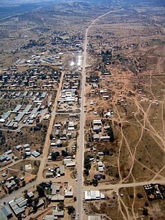
Opuwo is the capital of the Kunene Region in north-western Namibia. The town is situated about 720 km north-northwest from the capital Windhoek, and has a population of 20,000. Opuwo is the capital city of Kunene Region. The town is also the seat of the Regional Government and the commercial hub of the Kunene Region.
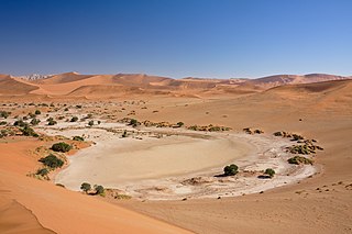
Sossusvlei is a salt and clay pan surrounded by high red dunes, located in the southern part of the Namib Desert, in the Namib-Naukluft National Park of Namibia. The name "Sossusvlei" is often used in an extended meaning to refer to the surrounding area, which is one of the major visitor attractions of Namibia.

The Tsauchab is an ephemeral river in the Hardap Region of central Namibia. Its source is in the southern Naukluft Mountains, from where it flows westwards through the Namib-Naukluft National Park into Sossusvlei, an endorheic basin. The lower river has in the past had a slightly different courses and also formed two other basins, the Deadvlei and the Hiddenvlei.

Sesriem is a small settlement located in the Namib Desert, in Namibia, close to the southern end of the Naukluft Mountains. It is especially known because the "Sesriem gate" is the main access point to the Namib-Naukluft National Park for visitors entering the park to visit the nearby tourist attraction of Sossusvlei. As many "settlements" in the Namib, Sesriem is essentially a filling station with basic services such as public telephones and a couple of small kiosks where travellers can get general supplies such as food and water. In the surroundings of Sesriem there are several accommodations, such as a few lodges and 24 campsites.
The River Trail was a main route for travel in the colonial era of what is now the Canadian province of British Columbia, running northwards along the Fraser River from to present day Lillooet to Big Bar, British Columbia and points beyond in the Cariboo District. The route was primarily in use during the Fraser Canyon Gold Rush and associated explorations by prospectors northwards in the search for gold in the Cariboo and Omineca Districts.
Skeleton Coast National Park is a national park located in northwest Namibia, and has the most inaccessible shores, dotted with shipwrecks. The park was established in 1971 and has a size of 16,845 km2 (6,504 sq mi). The park is divided into a northern and southern section, the southern section is open to those with 4 wheel drive vehicles, they are allowed to go up (north) as far as the Ugab River Gate. The northern section can only be reached by a fly-in safari, and the area is off-limits to all vehicles.

The Quiver Tree Forest is a forest and tourist attraction of southern Namibia. It is located about 14 km north-east of Keetmanshoop, on the road to Koës, on the Gariganus farm. It comprises about 250 specimens of Aloidendron dichotomum, a species that is also locally known as the quiver tree because San people traditionally used its branches to make quivers. The forest is spontaneous; the tallest quiver trees are two to three centuries old. The forest was declared a national monument of Namibia in 1995.
The Zemba are an indigenous people, and reside in Angola and also in Namibia

Gongoni Danga is a natural canyon situated near the town of Garbeta, in the Paschim Medinipur district of West Bengal, India.