Solitaire, Namibia

Last updated
Solitaire
Namibia location map.svg
Red pog.svg
Solitaire
Location in Namibia
Coordinates: 23°53′S16°0′E / 23.883°S 16.000°E / -23.883; 16.000
CountryFlag of Namibia.svg  Namibia
Region Khomas Region
Constituency Windhoek Rural Constituency
Time zone UTC+2 (South African Standard Time)
General dealer Solitaire, Namibia03.jpg
General dealer

Solitaire is a small settlement in the Khomas Region of central Namibia near the Namib-Naukluft National Park. It currently features the only gasoline station, bakery, cafe, and the only general dealer between the dunes at Sossusvlei and the coast at Walvis Bay, as well as on the road to the capital Windhoek. Solitaire belongs to the Windhoek Rural electoral constituency. [1]

Contents

Solitaire is known in the Netherlands because of a book with the same name by Dutch author Ton van der Lee, dealing with his stay at the settlement.

History

In 1948 Willem Christoffel van Coller bought 33,000 hectares of land from the South West Administration (the government of Namibia at the time) for the purpose of farming Karakul sheep. The land was previously an undeveloped area called Areb, situated between the Ababis region to the South and the Koireb region to the North.

The area was named Solitaire by Elsie Sophia van Coller (wife of Willem Christoffel van Coller). The name was chosen because of two meanings. Solitaire can mean a single set diamond and Solitaire can also mean solitude or loneliness. Combined these two meanings create the definition of being unique or one-of-a-kind and a precious but solitary place. [2]

The first man-made structure on the Solitaire farm was a 2-room cottage constructed by Mr. Van Coller who also later constructed the main farm house, a stone kraal adjacent to the farmhouse and a dam wall across the river bed. Later he was responsible for constructing the current shop and installing the first petrol pump. The shop acted as the regional post office where weekly postbags were delivered. In 1948, construction of a small chapel was started; it was completed in 1951. The small Dutch-Reformed church is still in use by the local congregation. The church building is also used as a community meeting place, holding Farmer's Union meetings, elections, and health clinics. In 1968 the farm 'Solitaire' was sold to a Mr. Maritz, and has since gone through numerous owners. The two farms that make up Solitaire, the businesses, and other area land holdings, are now part of the 45,000 acre Solitaire Land Trust, [3] which is focused on habitat preservation. This semi-arid region, frequented by drought, is home to healthy populations of wildlife, including the endemic Hartmann's mountain zebra. Farm Solitaire starts at the Great African Escarpment, an important watershed, and includes grasslands, gravel plains, ephemeral rivers and stretches to the edge of the Namib, one of the oldest deserts in the world.

Tourism

Aerial view of Solitaire and runway Solitaire (2019).jpg
Aerial view of Solitaire and runway
Hill at the entrance of Solitaire Solitaire - Namibia.jpg
Hill at the entrance of Solitaire
List of millimeters of rain that fell from 2009 to 2015 in Solitaire Rainfall in Solitaire.jpg
List of millimeters of rain that fell from 2009 to 2015 in Solitaire

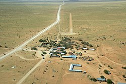
Solitaire is situated at the junction of two main roads - C14 (Walvis Bay - Bethanie), and C19 (Sesriem - Sossusvlei), both major tourist routes through the Namib-Naukluft National Park. There is also a well-maintained, hard-sand air strip frequented by charter operators, private aviators and self-fly tourists. AVGas is available by prior arrangement.

As the surrounding area is sparsely populated it is a common stopover for tourists. In addition to the petrol station, public restrooms, restaurant and bakery, the settlement contains a tyre repair workshop and a motel, the Solitaire Lodge. The adjacent farm land accommodates the upmarket Solitaire Desert Farm, 7 km away.

Related Research Articles

<span class="mw-page-title-main">Geography of Namibia</span>

At 824,292 km2 (318,261 sq mi), Namibia is the world's thirty-fourth largest country. After Mongolia, Namibia is the second least densely populated country in the world. Namibia got its name from the Namib desert that stretches along the coast of the Atlantic. It is also known for its wildlife.

<span class="mw-page-title-main">Walvis Bay</span> Coastal town in Namibia

Walvis Bay is a city in Namibia and the name of the bay on which it lies. It is the second largest city in Namibia and the largest coastal city in the country. The city covers an area of 29 square kilometres (11 sq mi) of land. The bay is a safe haven for sea vessels because of its natural deep-water harbour, protected by the Pelican Point sand spit, being the only natural harbour of any size along the country's coast. Being rich in plankton and marine life, these waters also draw large numbers of southern right whales, attracting whalers and fishing vessels.

<span class="mw-page-title-main">Namib</span> Desert in Southern Africa

The Namib is a coastal desert in Southern Africa. According to the broadest definition, the Namib stretches for more than 2,000 kilometres (1,200 mi) along the Atlantic coasts of Angola, Namibia, and northwest South Africa, extending southward from the Carunjamba River in Angola, through Namibia and to the Olifants River in Western Cape, South Africa. The Namib's northernmost portion, which extends 450 kilometres (280 mi) from the Angola-Namibia border, is known as Moçâmedes Desert, while its southern portion approaches the neighboring Kalahari Desert. From the Atlantic coast eastward, the Namib gradually ascends in elevation, reaching up to 200 kilometres (120 mi) inland to the foot of the Great Escarpment. Annual precipitation ranges from 2 millimetres (0.079 in) in the aridest regions to 200 millimetres (7.9 in) at the escarpment, making the Namib the only true desert in southern Africa. Having endured arid or semi-arid conditions for roughly 55–80 million years, the Namib may be the oldest desert in the world and contains some of the world's driest regions, with only western South America's Atacama Desert to challenge it for age and aridity benchmarks.

<span class="mw-page-title-main">Namib-Naukluft National Park</span> National park in Namibia

The Namib-Naukluft Park is a national park in western Namibia, situated between the coast of the Atlantic Ocean and the edge of the Great Escarpment. It encompasses part of the Namib Desert, the Naukluft mountain range, and the lagoon at Sandwich Harbour. The best-known area of the park and one of the main visitor attractions in Namibia is Sossusvlei, a clay pan surrounded by dunes, and Sesriem, a small canyon of the Tsauchab. The desert research station of Gobabeb is situated within the park.

<span class="mw-page-title-main">Kuiseb River</span> River in Erongo, Namibia

The Kuiseb River is an ephemeral river in western-central Namibia. Its source is in the Khomas Highland west of Windhoek. From there it flows westwards through the Namib-Naukluft National Park and the Namib desert to Walvis Bay. Several settlements of the Topnaar people are on the banks of the lower Kuiseb, for instance Homeb, Sandfontein, Rooibank, and Utuseb. Inflows of the Kuiseb are Gomab, Ojab, Chausib, Gaub, Koam, Nausgomab and Goagos.

<span class="mw-page-title-main">Windhoek Rural</span> Electoral constituency in the Khomas region of central Namibia

Windhoek Rural is a constituency in the Khomas Region of Namibia. Its district capital is the settlement of Groot Aub. It had a population of 22,254 in 2011, up from 20,212 in 2001. As of 2020, it has 13,625 registered voters.

<span class="mw-page-title-main">Uis</span> Settlement in Erongo Region, Namibia

Uis is a settlement located in the Erongo Region, Namibia. It belongs to the Dâures electoral constituency. Located in the former Damaraland, it is known for the local mineral wealth. The settlement was established in 1958 as workers' settlement to exploit local tin deposits. It has approximately 3,600 inhabitants and, before being downgraded from "village" to "settlement" in 2010, owned 10 square kilometres (3.9 sq mi) of land.

<span class="mw-page-title-main">Sossusvlei</span> Salt and clay pan in the Namib Desert, Namibia

Sossusvlei is a salt and clay pan surrounded by high red dunes, located in the southern part of the Namib Desert, in the Namib-Naukluft National Park of Namibia. The name "Sossusvlei" is often used in an extended meaning to refer to the surrounding area. These landmarks are some of the major visitor attractions of Namibia.

Sandwich Harbour, also known as Sandwich Bay, Sandvishawe, Sandvisbaai and Sandfisch Bai is an area on the Atlantic coast of Namibia that includes a bay in the north and a lagoon at the southern end. Sandwich Harbour might have been named after an English whaling ship, the Sandwich, which worked during the 1780s, or the name may be a corruption of the German word "sandfische", a species of shark found in the area. Formerly, the bay was a moderately-sized commercial port based around whaling and small-scale fishing, but it is now best known for its birdlife in the lagoon to the south of the bay.

Articles related to Namibia include:

<span class="mw-page-title-main">Swakop River</span> River in Namibia

The Swakop River is a major river in western central Namibia. Its source is in the Khomas Highland. From there it flows westwards through the town of Okahandja, the historic mission station at Gross Barmen, and the settlement of Otjimbingwe. It then crosses the Namib desert and reaches the Atlantic Ocean at Swakopmund. The Swakop is an ephemeral river; its run-off is roughly 40 million cubic metres per annum.

<span class="mw-page-title-main">Tsauchab</span> River in central Namibia

The Tsauchab is an ephemeral river in the Hardap Region of central Namibia. Its source is in the southern Naukluft Mountains, from where it flows westwards through the Namib-Naukluft National Park into Sossusvlei, an endorheic basin. The lower river has in the past had a slightly different courses and also formed two other basins, the Deadvlei and the Hiddenvlei.

<span class="mw-page-title-main">Sesriem</span> Place in Hardap Region, Namibia

Sesriem is a small settlement in the Namib Desert, in the Hardap Region of Namibia, close to the southern end of the Naukluft Mountains. It is especially known because the "Sesriem gate" is the main access point to the Namib-Naukluft National Park for visitors entering the park to visit the nearby tourist attraction of Sossusvlei. As many "settlements" in the Namib, Sesriem is essentially a filling station with basic services such as public telephones and a couple of small kiosks where travellers can get general supplies such as food and water. In the surroundings of Sesriem there are several accommodation establishments, such as a few lodges and 24 campsites.

<span class="mw-page-title-main">Tourism in Namibia</span> Economic sector in Namibia

Tourism in Namibia is a major industry, contributing N$7.2 billion to the country's gross domestic product. Annually, over one million travelers visit Namibia, with roughly one in three coming from South Africa, then Germany and finally the United Kingdom, Italy and France. The country is among the prime destinations in Africa and is known for ecotourism which features Namibia's extensive wildlife.

<span class="mw-page-title-main">Deadvlei</span> Clay pan in the Namib-Naukluft Park in Namibia

Deadvlei is a white clay pan located near the more famous salt pan of Sossusvlei, in a valley between the dunes in the Namib-Naukluft Park in Namibia. Also written DeadVlei or Dead Vlei, its name means "dead marsh". The pan also is referred to as "Dooie Vlei" which is the Afrikaans name. There are many references to the site on the Internet, its name often being translated erroneously in terms such as "dead valley"; a vlei is not a valley. Nor is the site a valley; the pan is a desiccated vlei.

The Naankuse Foundation Wildlife Sanctuary is a wildlife sanctuary in central Namibia, situated c. 42 kilometres (26 mi) outside Windhoek. Besides the sanctuary the establishment also runs a carnivore conservation research programme, the Clever Cubs pre-primary school, and a clinic for the San people. Nǀaʼankusê is a Juǀʼhoan word that means "God will protect us", or "God watches over us." The sanctuary opened in 2007. It is run by Namibian conservationist Marlice van Vuuren and her husband Rudie van Vuuren. Naankuse is funded by voluntary donations and relies on the time of volunteers to continue its projects.

<span class="mw-page-title-main">Spreetshoogte Pass</span>

Spreetshoogte Pass is a mountain pass in central Namibia, connecting the Namib Desert with the Khomas Highland by traversing the Great Escarpment, a geological feature of much of the southern part of the African continent. With gradients between 1:4.5 and 1:6 it is the steepest pass in Namibia, as well as the one straddling the biggest elevation difference, descending almost 1,000 metres (3,300 ft) within 4 kilometres (2.5 mi) of road. The top of the pass features a rest place from which there are views into the adjacent Namib.

Utuseb is a small settlement in the Erongo Region in western central Namibia. It is situated in the Namib Desert, approximately 40 kilometres (25 mi) from Walvis Bay on the banks of Kuiseb River. Utuseb has approximately 700 inhabitants and belongs to the Walvis Bay Rural electoral constituency. The people living here belong to the ǂAonin community, a subtribe of the Nama people.

<span class="mw-page-title-main">Dorob National Park</span> National park of Namibia

The Dorob National Park is a protected area in the Erongo region, along the central Namibian coast, which is 1,600 kilometres (990 mi) in length. It was gazetted as a national park under the Nature Conservation Ordinance No.4 of 1975 on 1 December 2010, and with Namib-Naukluft Park it covers an area of 107,540 square kilometres (41,520 sq mi).

References

  1. Kapitako, Alvine (12 November 2010). "ELECTIONS 2010: Khomas Region profile". New Era . Archived from the original on 5 December 2012.
  2. "Solitaire Country Lodge". The Cardboard Box travel shop. Retrieved 1 July 2014.
  3. "Solitaire Namibia – Welcoming Travellers Since 1949". www.solitairenamibia.com. Retrieved 2017-10-23.

23°53′S16°00′E / 23.883°S 16.000°E / -23.883; 16.000