The Kalahari Desert is a large semi-arid sandy savanna in Southern Africa extending for 900,000 square kilometres (350,000 sq mi), covering much of Botswana, and parts of Namibia and South Africa.

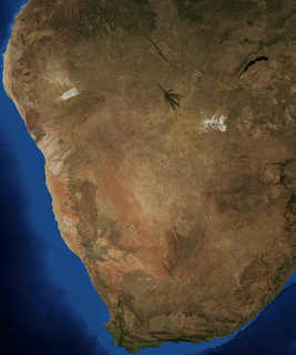
At 824,292 km2 (318,261 sq mi), Namibia is the world's thirty-fourth largest country. After Mongolia, Namibia is the second least densely populated country in the world.
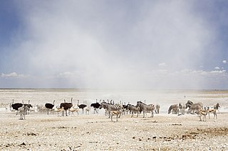
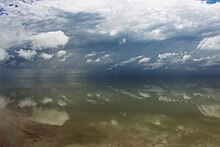
Etosha National Park is a national park in northwestern Namibia and one of the largest national parks in Africa. It was proclaimed a game reserve in March 1907 in Ordinance 88 by the Governor of German South West Africa, Friedrich von Lindequist. It was designated as Wildschutzgebiet in 1958, and was elevated to the status of a national park in 1967 by an act of parliament of the Republic of South Africa. It spans an area of 22,270 km2 (8,600 sq mi) and gets its name from the large Etosha pan which is almost entirely within the park. With an area of 4,760 km2 (1,840 sq mi), the Etosha pan covers 23% of the total area of the national park. The area is home to hundreds of species of mammals, birds and reptiles, including several threatened and endangered species such as the black rhinoceros.

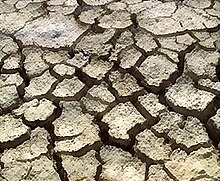
Natural salt pans or salt flats are flat expanses of ground covered with salt and other minerals, usually shining white under the sun. They are found in deserts and are natural formations.
Kaokoland was an administrative unit and a bantustan in northern South West Africa. Established during the apartheid era, it was intended to be a self-governing homeland of the OvaHimba, but an actual government was never established. Like other homelands in South West Africa, the Kaokoland bantustan was abolished in May 1989, at the beginning of the transition of Namibia towards independence. "Kaokoland" remains as an informal name for the geographic area, while the political unit of administration since 1990 is Kunene Region. The area is in the Kaokoveld ecoregion.

The Kaokoveld Desert is a coastal desert of northern Namibia and southern Angola.

The Makgadikgadi Pan, a salt pan situated in the middle of the dry savanna of north-eastern Botswana, is one of the largest salt flats in the world. The pan is all that remains of the formerly enormous Lake Makgadikgadi, which once covered an area larger than Switzerland, but dried up tens of thousands of years ago. Recent studies of human mitochondrial DNA suggest that modern Homo sapiens first began to evolve in this region some 200,000 years ago, when it was a vast, exceptionally fertile area of lakes, rivers, marshes, woodlands and grasslands especially favorable for habitation by evolving hominins and other mammals.

The Wildlife of Djibouti, consisting of flora and fauna, is in a harsh landscape with forest accounting for less than one percent of the total area of the country. The flora and fauna species are most found in the northern part of the country in the ecosystem of the Day Forest National Park at an average altitude 1,500 metres (4,900 ft), including the massif Goda, with a peak of 1,783 metres (5,850 ft). It covers an area of 3.5 square kilometres (1.4 sq mi) of Juniperus procera forest, with many of the trees rising to 20 metres (66 ft) height. This forest area is the main habitat of critically endangered and endemic Djibouti spurfowl, and another recently noted vertebrate, Platyceps afarensis. The area also contains many species of woody and herbaceous plants, including boxwood and olive trees, which account for sixty percent of the total identified species in the country.

The Zambezian flooded grasslands is an ecoregion of southern and eastern Africa that is rich in wildlife.

Angolan mopane woodlands are situated in southwestern Angola, extending into northern Namibia. This ecosystem surrounds Etosha Pan, which is considered a separate ecoregion. The mopane trees are the main type of vegetation.

The Kalahari Acacia-Baikiaea woodlands are an ecoregion located in Botswana, northern Namibia, South Africa and Zimbabwe.

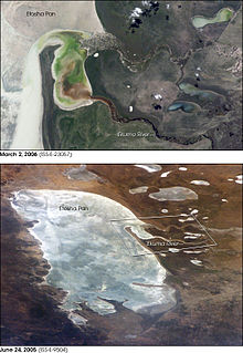
Ekuma River is one of the three rivers that supply a majority of water to the pan in the Etosha National Park in Namibia. The other two rivers being Oshigambo River and Omurambo Ovambo River. Ekumo is an ephemeral river that occasionally flows, or forms pools, during the rainy season. It originates from the southern shores of Lake Oponono and is 250 kilometres (160 mi) long.

Lake Oponona is a natural lake in the Uuvudhiya Constituency in the Oshana Region of northern Namibia. It is situated about 70 kilometres (43 mi) from Etosha Pan and is the largest lake in the Cuvelai Basin.

Mudumu is a National Park in Caprivi Region in north-eastern Namibia. The park was established in 1990. It covers an area of 737 square kilometres (285 sq mi). The Kwando River forms the western border with Botswana. Various communal area conservancies and community forests surround Mudumu National Park.

The Hoanib is one of the 12 ephemeral seasonal rivers in the west of Namibia, where it was the border between northern Damaraland and Kaokoland. Its length is 270 km. With the low population density, the oasis character of the river valley and the relatively high wildlife population of Hoanib, together with the Hoarusib its valley is one of the last true wilderness areas in Namibia, one of the last settlements of desert elephants and shows strong wind and water eroded and weathered stone deposits. Inflows of Hoanib are Aap River, Otjitaimo River, Ombonde, Ganamub, Mudorib and Tsuxub.

Desert elephants or desert-adapted elephants are not a distinct species of elephant but are African bush elephants that have made their homes in the Namib and Sahara deserts in Africa. At one time they were classified as a subspecies of the African bush elephant, but this is no longer the case. Desert-dwelling elephants were once more widespread in Africa than they are now and are currently found only in Namibia and Mali. They tend to migrate from one waterhole to another following traditional routes which depend on the seasonal availability of food and water. They face pressure from poaching and from changes in land use by humans.
Hakskeenpan is a mud and salt pan in the Kalahari Desert, in Southern Africa. It is located in the Mier region in the Northern Cape Province, in South Africa, at 801 meters (2,628 ft) above sea level. The pan covers an area of approximately 140 km2 (54mi2).
The Zambezian region is a large biogeographical region in Africa. The Zambezian region includes woodlands, savannas, grasslands, and thickets, extending from east to west in a broad belt across the continent. The Zambezian region lies south of the rainforests of the Guineo-Congolian region. The Zambezian region is bounded by deserts and xeric shrublands on the southwest, the Highveld grasslands of South Africa to the south, and the subtropical Maputaland forests on the southeast.

The Namibian savanna woodlands, also known as the Namib escarpment woodlands, are deserts and xeric shrublands ecoregion of Namibia and Angola.

The Saharan halophytics ecoregion covers a series of low-lying evaporite depressions and wetlands spread across North Africa. The depressions are characteristically saline, variously chotts or sabkhas. The plants of the areas are highly specialized to survive in the harsh environment, with many being xerophytes (drought-tolerant) and halophytes (salt-tolerant). The biodiversity of the areas has been relatively protected by their isolation, and unsuitability of alkaline soil for farming.