
The Decca Navigator System was a hyperbolic radio navigation system that allowed ships and aircraft to determine their position by using radio signals from a dedicated system of static radio transmitters. The system used phase comparison between pairs of low frequency signals between 70 and 129 kHz, as opposed to pulse timing systems like Gee and LORAN. This made it much easier to design receivers using 1940s electronics, and operation was simplified by giving a direct readout of Decca coordinates without the complexity of a cathode-ray tube and highly skilled operator.

Loran-C is a hyperbolic radio navigation system that allows a receiver to determine its position by listening to low frequency radio signals that are transmitted by fixed land-based radio beacons. Loran-C combined two different techniques to provide a signal that was both long-range and highly accurate, features that had been incompatible. Its disadvantage was the expense of the equipment needed to interpret the signals, which meant that Loran-C was used primarily by militaries after it was introduced in 1957.
Radio navigation or radionavigation is the application of radio waves to determine a position of an object on the Earth, either the vessel or an obstruction. Like radiolocation, it is a type of radiodetermination.
Low frequency (LF) is the ITU designation for radio frequencies (RF) in the range of 30–300 kHz. Since its wavelengths range from 10–1 km, respectively, it is also known as the kilometre band or kilometre waves.

A radio clock or radio-controlled clock (RCC), and often colloquially referred to as an "atomic clock", is a type of quartz clock or watch that is automatically synchronized to a time code transmitted by a radio transmitter connected to a time standard such as an atomic clock. Such a clock may be synchronized to the time sent by a single transmitter, such as many national or regional time transmitters, or may use the multiple transmitters used by satellite navigation systems such as Global Positioning System. Such systems may be used to automatically set clocks or for any purpose where accurate time is needed. Radio clocks may include any feature available for a clock, such as alarm function, display of ambient temperature and humidity, broadcast radio reception, etc.

OMEGA was the first global-range radio navigation system, operated by the United States in cooperation with six partner nations. It was a hyperbolic navigation system, enabling ships and aircraft to determine their position by receiving very low frequency (VLF) radio signals in the range 10 to 14 kHz, transmitted by a global network of eight fixed terrestrial radio beacons, using a navigation receiver unit. It became operational around 1971 and was shut down in 1997 in favour of the Global Positioning System.

Rugby Radio Station was a large British government radio transmission facility just east of the Hillmorton area of the town of Rugby, Warwickshire in England. The site straddled the A5 trunk road, with most of it in Warwickshire, and part on the other side of the A5 in Northamptonshire. First opened in 1926, at its height in the 1950s it was the largest radio transmitting station in the world, with a total of 57 radio transmitters, covering an area of 1,600 acres (650 ha). Traffic slowly dwindled from the 1980s onwards, and the site was closed between 2003 and 2007.
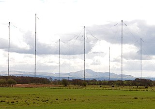
Anthorn Radio Station is a naval and government radio transmitting station located near Anthorn, Cumbria, England, overlooking the Solway Firth, and is operated by Babcock International. It has three transmitters: one VLF; one LF; and an eLoran transmitter.

Alpha, also known as RSDN-20, is a Russian system for long range radio navigation. RSDN in Russian stands for Радиотехническая Система Дальней Навигации, which translates to English as "radio-technical long-distance navigation system".

An umbrella antenna is a capacitively top-loaded wire monopole antenna, consisting in most cases of a mast fed at the ground end, to which a number of radial wires are connected at the top, sloping downwards. One side of the feedline supplying power from the transmitter is connected to the mast, and the other side to a ground (Earthing) system of radial wires buried in the earth under the antenna. They are used as transmitting antennas below 1 MHz, in the MF, LF and particularly the VLF bands, at frequencies sufficiently low that it is impractical or infeasible to build a full size quarter-wave monopole antenna. The outer end of each radial wire, sloping down from the top of the antenna, is connected by an insulator to a supporting rope or cable anchored to the ground; the radial wires can also support the mast as guy wires. The radial wires make the antenna look like the wire frame of a giant umbrella hence the name.
Forestport Tower was a guyed, steel tower, insulated from the earth, so that the entire structure was used to radiate electromagnetic waves in the VLF and LF bands. The tower, known locally as “the stick” or “the Forestport stick”, was located near Forestport in Oneida County, New York, United States. Forestport Tower was built in 1950. It had a height of 1218 ft. Forestport Tower was used for experimental transmissions in the LF and VLF-range; some of these included the first tests of the LORAN-C and Omega Navigation System. On April 21, 1998 it was demolished by explosives.
LORAN-C transmitter Carolina Beach was the Zulu secondary station of the U.S. Southeast chain of LORAN-C. The transmitter power was 800 kW. The free-standing antenna of 190.5 metres (625 ft) height was situated near Carolina Beach, North Carolina. After the shutdown of Loran-C in the U.S. in 2010, the transmitter and tower radiator were removed.
LORAN-C transmitter Ejde was the Master station of the Ejde LORAN-C Chain. It used a transmission power of 400 kW. Ejde LORAN-C transmitter, situated near Eiði at. Ejde LORAN-C transmitter used as antenna a 190.5 metre tall mast radiator. In 1962 the mast of LORAN-C transmitter Ejde collapsed as a result of a slipping guy rope. The mast has been demolished.

LORAN-C transmitter Malone was the master station of the Southeast U.S. LORAN-C Chain and the Whiskey Secondary of the Great Lakes chain. It used a transmission power of 800 kW for both chains.
LORAN-C transmitter Jupiter was the Yankee secondary station of the Southeast U.S. LORAN-C Chain. It was operated from years 1962 to 2010 by the U.S. Coast Guard, located on Florida land that was originally Camp Murphy and now Jonathan Dickinson State Park, near the town of Jupiter, Florida. The choice of this site followed the earlier LORAN-A station established in 1957 nearby on the Atlantic beach at Hobe Sound.
Chayka transmitter Slonim is the 2nd secondary station of the Western Russian Chain RSDN-3 with a transmission power of 450 kW. Chayka transmitter Slonim, situated near Slonim, Belarus at 53°7′55.2″N25°23′46″E.

Submarine navigation underwater requires special skills and technologies not needed by surface ships. The challenges of underwater navigation have become more important as submarines spend more time underwater, travelling greater distances and at higher speed. Military submarines travel underwater in an environment of total darkness with neither windows nor lights. Operating in stealth mode, they cannot use their active sonar systems to ping ahead for underwater hazards such as undersea mountains, drilling rigs or other submarines. Surfacing to obtain navigational fixes is precluded by pervasive anti-submarine warfare detection systems such as radar and satellite surveillance. Antenna masts and antenna-equipped periscopes can be raised to obtain navigational signals but in areas of heavy surveillance, only for a few seconds or minutes; current radar technology can detect even a slender periscope while submarine shadows may be plainly visible from the air.

Hyperbolic navigation is a class of radio navigation systems in which a navigation receiver instrument is used to determine location based on the difference in timing of radio waves received from radio navigation beacon transmitters.

LORAN was a hyperbolic radio navigation system developed in the United States during World War II. It was similar to the UK's Gee system but operated at lower frequencies in order to provide an improved range up to 1,500 miles (2,400 km) with an accuracy of tens of miles. It was first used for ship convoys crossing the Atlantic Ocean, and then by long-range patrol aircraft, but found its main use on the ships and aircraft operating in the Pacific theater during World War II.

