CLASP (British Rail)

Last updated

CLASP structure at Ashtead Ashtead Station 01.JPG
CLASP structure at Ashtead

The CLASP (Consortium of Local Authorities Special Programme) system was a scheme developed in the 1950s by English local authorities to devise a method of designing and assembling prefabricated buildings for use in the public sector. The former Southern Region of British Rail, the state-owned railway operator, adopted the system in the 1960s and 1970s and used it for signalboxes and station buildings. [1] The Western Region also rebuilt some stations using the same methods.

Contents

History

After the Second World War, many stations and signalboxes on the Southern Region's large and busy network required renewal or replacement, but funds were limited: several electrification schemes had to be paid for, new trains were required and other modernisation work was taking place. By the 1960s, the need for immediate action became so great that the Region's management had to abandon traditional individual rebuilding projects in favour of a mass-produced solution using factory-made parts. [1] [2]

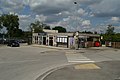
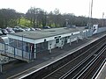
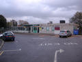
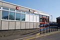
The CLASP method, used since the 1950s by local authorities for schools and other public buildings, was chosen. The prefabricated buildings were made of steel and concrete, and had several distinctive characteristics: a steel-framed, flat-roofed "box", usually one storey high (although some two-storey versions were produced), [3] with a large water tank mounted on the roof. Windows were small and placed high on the building, immediately below the roof. Evenly spaced wooden or metal pillars held up canopies which were usually wood-panelled underneath. Pre-formed panels of aggregate-coated concrete formed the outer walls. [1]

The first CLASP signalboxes were built in 1964; in 1965, the scope was widened to include stations.[ citation needed ] The structures were cheaply built and quickly decayed; [4] several were soon replaced by new buildings. The Southern Region abandoned the scheme in 1973, [4] although the Western Region adopted it at three locations between 1971 and 1977.

List of stations rebuilt using CLASP methods

StationImageRegionYearNotesRefs
Sunbury Sunbury station building.JPG Southern Region 1965 [4]
Fleet Southern Region 1966Rebuilt 2013–2014 [4] [5]
Crawley Crawley Station 01 (07-07-2007).JPG Southern Region 1967Incorporated an office development above [1] [6] [7]
Alfreton Alfreton Station - geograph.org.uk - 1373142.jpg London Midland Region 1967
Ashtead Ashtead Station 01.JPG Southern Region 1968Rebuilt 2013 [4] [8]
Aylesham Aylesham Train Station1.JPG Southern Region 1968 [9]
Belmont Southern Region 1968Now demolished [4] [10]
Belvedere Southern Region 1968Rebuilt in 2000 [4] [11] [12]
Charlton Charlton station building.JPG Southern Region 1968 [4] [13]
Crayford Southern Region 1968Destroyed by fire in 2000; replaced by new building in 2001 [4] [14] [15]
New Eltham Southern Region 1968Since rebuilt [16]
Slade Green Slade Green stn main entrance.JPG Southern Region 1968 [4] [17]
Berrylands Berrylands station main entrance.JPG Southern Region 1969 [4] [18]
Hampton Wick Hampton Wick stn main entrance.JPG Southern Region 1969 [4] [19]
Catford Catford station building.JPG Southern Region 1970 [4] [20] [21]
Poole Southern Region 1970Since rebuilt [22]
Oxford Western Region 1971Up side rebuilt 1990; down side scheduled for replacement
Longfield Longfield Railway Station - geograph.org.uk - 1352129.jpg Southern Region 1971 [23] [24]
Meopham Meopham railway station in 2009.jpg Southern Region 1971 [25] [26]
Bristol Parkway Western Region 1972Opened 1 May 1972 with temporary CLASP buildings; rebuilt in 2001
Kidbrooke Southern Region 1972Since rebuilt [27]
Rainham (Kent) Southern Region 1972Demolished in 1989; rebuilt in 1990 [28] [29]
East Grinstead East Grinstead Station 1.jpg Southern Region 1973New station built 2012; demolished in 2013 [4] [7] [30] [31]
Hassocks Hassocks Station.png Southern Region 1973Rebuilt 2012–2013 [4] [7] [32]
Sunningdale Southern Region 1973
Virginia Water Southern Region 1973
Wokingham Southern Region 1973Rebuilt 2013
West Norwood Southern Region 1975
Gloucester Western Region 1977Incorporated an office development above
Lower Sydenham Southern Region Since rebuilt [4] [33]
Strood Strood Station 5821.JPG Southern Region Rebuilt 2017 [4] [34]
Forest Hill Forest Hill stn main building.JPG Southern Region [35]
Brockley Brockley station eastern entrance 2010.JPG Southern Region An unusual two-storey CLASP structure [3]
Wool Wool Railway Station (Main Building) (Geograph Image 762954 11ecff83).jpg Southern Region [36]

SCOLA

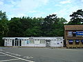
The SCOLA (Second Consortium of Local Authorities) scheme, similar to CLASP, was also developed for use by schools. [37] Its buildings made use of brick and timber instead of concrete. British Rail used it twice on the Southern Region, when Newington and Teynham stations were rebuilt in the late 1970s to suit one-man operation. [2]

Post-1970s developments

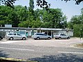
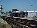
From 1980 and throughout the next ten years and into the 1990s, British Rail adopted a new system of brick buildings with apex roofs, smaller examples resembling a 'chalet'. These include Headcorn, Staplehurst and Marden. [38]

Related Research Articles

<span class="mw-page-title-main">Charing Cross railway station</span> Central London railway terminus

Charing Cross railway station is a central London railway terminus between the Strand and Hungerford Bridge in the City of Westminster. It is the terminus of the Southeastern Main Lines to Dover via Ashford and Hastings via Tunbridge Wells. All trains are operated by Southeastern, which provides the majority of commuter and regional services to south-east London and Kent. It is connected to Charing Cross Underground station and is near to Embankment Underground station and Embankment Pier.

<span class="mw-page-title-main">Brighton railway station</span> Railway station in Brighton, East Sussex, England

Brighton railway station is the southern terminus of the Brighton Main Line, the western terminus of the East Coastway Line and the eastern terminus of the West Coastway Line in England, and the principal station serving the city of Brighton, East Sussex. It is 50 miles 49 chains from London Bridge via Redhill. The station has six bus stops which are served by Brighton & Hove bus routes 1, 1A, N1, 5B, 6, 7, N7, 12, 12A, 12X, 13X, 14, 14C, 18, 24, 26, 27, 27B, 27C, 46, 48, 49, 55, 59 and 79.

<span class="mw-page-title-main">Holborn Viaduct railway station</span> Closed London railway station

Holborn Viaduct was a railway station in the City of London, providing local and commuter services. It was located to the southeast of Holborn Viaduct, and east of Farringdon Street.

<span class="mw-page-title-main">Marshlink line</span> Railway line in South East England

The Marshlink line is a railway line in South East England. It runs from Ashford, Kent via Romney Marsh, Rye and the Ore Tunnel to Hastings where it connects to the East Coastway line towards Eastbourne and Brighton.

<span class="mw-page-title-main">Lower Sydenham railway station</span> National Rail station in London, England

Lower Sydenham railway station is located on the boundary of the London Borough of Bromley and the London Borough of Lewisham in south-east London. It is 9 miles 2 chains (14.5 km) measured from London Charing Cross.

<span class="mw-page-title-main">Meopham railway station</span> Railway station in Kent, England

Meopham railway station is on the Chatham Main Line in England, serving the village of Meopham, Kent. It is 25 miles 76 chains (41.8 km) down the line from London Victoria and is situated between Longfield and Sole Street. The station is managed by Southeastern.

<span class="mw-page-title-main">Longfield railway station</span> Railway station in Kent, England

Longfield railway station is on the Chatham Main Line in England, serving the villages of Longfield, Hartley, and New Ash Green. It is 23 miles 30 chains (37.6 km) down the line from London Victoria and is situated between Farningham Road and Meopham.

<span class="mw-page-title-main">Canterbury West railway station</span> Railway station in Kent, England

Canterbury West railway station is a Grade II listed railway station, and the busier of the two stations in Canterbury in Kent, England. The station as well as all services are operated by Southeastern with both main line and high speed trains serving the station.

<span class="mw-page-title-main">Ashford International railway station</span> Railway station in Kent, England

Ashford International railway station is a National Rail station in Ashford, Kent, England. It connects several railway lines, including High Speed 1 and the South Eastern Main Line. Services are operated by Southeastern and Southern.

<span class="mw-page-title-main">Hastings line</span> Railway line in Kent and East Sussex, England

The Hastings line is a secondary railway line in Kent and East Sussex, England, linking Hastings with the main town of Tunbridge Wells, and London via Tonbridge and Sevenoaks. Although primarily carrying passengers, the railway also serves a gypsum mine which is a source of freight traffic. Southeastern Trains operates passenger trains on the line, and it is one of their busiest lines.

<span class="mw-page-title-main">Tonbridge railway station</span> Railway station in Kent, England

Tonbridge railway station is on the South Eastern Main Line in England, serving the town of Tonbridge, Kent. It is 29 miles 46 chains (47.6 km) from London Charing Cross via Sevenoaks. Trains calling at the station are operated by Southeastern and Southern.

<span class="mw-page-title-main">Staplehurst railway station</span> Railway station in Kent, England

Staplehurst railway station is on the South Eastern Main Line in England, serving the village of Staplehurst, Kent. It is 41 miles 70 chains (67.4 km) down the line from London Charing Cross. The station and all trains that serve the station are operated by Southeastern.

<span class="mw-page-title-main">Headcorn railway station</span> Railway station in Kent, England

Headcorn railway station is on the South Eastern Main Line in England, serving the village of Headcorn, Kent. It is 45 miles 20 chains (72.8 km) down the line from London Charing Cross. The station and all trains that serve the station are operated by Southeastern.

<span class="mw-page-title-main">Deal railway station</span> Railway station in Kent, England

Deal railway station serves Deal in Kent, England. The station and all trains serving it are operated by Southeastern. The station is on the Kent Coast Line 9.5 miles (15.3 km) north east of Dover Priory and 86.75 miles (139.61 km) south east of London Charing Cross.

<span class="mw-page-title-main">Queenborough railway station</span> Railway station in Kent, England

Queenborough railway station is on the Sheerness Line, on the Isle of Sheppey in northern Kent, and serves the town of Queenborough. It is 49 miles 22 chains (79.3 km) down the line from London Victoria.

<span class="mw-page-title-main">Winchelsea railway station</span> Railway station in East Sussex, England

Winchelsea railway station is a railway station in East Sussex, England. It is about 0.62 miles (1 km) from Winchelsea and is actually in the neighbouring parish of Udimore. It is on the Marshlink line 9.3 miles (15 km) north east of Hastings, and train services are provided by Southern. The station originally had two platforms, but in 1979, the line was singled and only the up platform is now in use. The former down platform and station building are now converted to a private house.

<span class="mw-page-title-main">Appledore railway station</span> Railway station in Kent, England

Appledore railway station is a Grade II listed station east of Appledore in Kent, England. It is on the Marshlink line, and train services are provided by Southern.

<span class="mw-page-title-main">South Eastern Main Line</span> Major long-distance railway line in south-east England

The South Eastern Main Line is a major long-distance railway route in South East England, UK, one of the three main routes crossing the county of Kent, going via Sevenoaks, Tonbridge, Ashford and Folkestone to Dover. The other routes are the Chatham Main Line which runs along the north Kent coast to Ramsgate or Dover via Chatham and High Speed 1 which runs through the centre of Kent to the coast at Folkestone where it joins the Channel Tunnel.

<span class="mw-page-title-main">Northiam railway station</span> Railway station in England

Northiam railway station is on the Kent and East Sussex Railway. It is located to the west of the level crossing on the A28 road linking the Kentish village of Newenden and the East Sussex village of Northiam. Having served the area for over sixty years, the station closed with the line in 1961, but was later reopened in 1990 by the Kent and East Sussex Railway heritage organisation.

<span class="mw-page-title-main">Lullingstone railway station</span>

Lullingstone railway station is an unopened station on the Maidstone line which was constructed to serve a proposed airport and expected residential development at Lullingstone near Eynsford in Kent. The station was never brought into use as World War II and subsequent post-war planning legislation put an end to the plans for the area. Largely demolished in 1955, the remains of the station are visible to the south of the Eynsford Tunnel.

References

Notes

  1. 1 2 3 4 Brown & Jackson 1990 , p. 77.
  2. 1 2 von Marshall-Blitz, Fritz (2006–2008). "Station Architecture under Network SouthEast". Network SouthEast Railway Society. Archived from the original on 9 July 2009. Retrieved 24 October 2009.
  3. 1 2 Body 1984 , p. 57.
  4. 1 2 3 4 5 6 7 8 9 10 11 12 13 14 15 16 17 Brown & Jackson 1990 , p. 78.
  5. Body 1984 , p. 96.
  6. Hoare 1979 , p. 102.
  7. 1 2 3 Hoare 1979 , p. 104.
  8. Body 1984 , p. 40.
  9. "Aylesham Halt". Kent Rail website. David Glasspool. 2009. Retrieved 24 October 2009.
  10. Body 1984 , p. 91.
  11. Body 1984 , p. 138.
  12. "Belvedere". Kent Rail website. David Glasspool. 2009. Retrieved 24 October 2009.
  13. Body 1984 , p. 137.
  14. Body 1984 , p. 77.
  15. "Crayford". Kent Rail website. David Glasspool. 2009. Retrieved 24 October 2009.
  16. "New Eltham". Kent Rail website. David Glasspool. 2009. Retrieved 24 October 2009.
  17. "Slade Green". Kent Rail website. David Glasspool. 2009. Retrieved 24 October 2009.
  18. Body 1984 , p. 44.
  19. Body 1984 , p. 105.
  20. Body 1984 , p. 64.
  21. "Catford". Kent Rail website. David Glasspool. 2009. Retrieved 24 October 2009.
  22. "Poole". The Somerset & Dorset Joint Railway website. Kevin Clapcott. 10 August 2007. Archived from the original on 21 November 2008. Retrieved 24 October 2009.
  23. "Longfield". Kent Rail website. David Glasspool. 2009. Retrieved 24 October 2009.
  24. Body 1984 , p. 125.
  25. "Meopham". Kent Rail website. David Glasspool. 2009. Retrieved 24 October 2009.
  26. Body 1984 , p. 130.
  27. "Kidbrooke". Kent Rail website. David Glasspool. 2009. Retrieved 24 October 2009.
  28. "Rainham". Kent Rail website. David Glasspool. 2009. Retrieved 24 October 2009.
  29. Body 1984 , p. 154.
  30. Body 1984 , p. 88.
  31. Hoare 1979 , p. 103.
  32. Body 1984 , p. 106.
  33. Body 1984 , p. 126.
  34. Robinson, Andy (11 December 2017). "Strood's new £2.5m train station officially opens today". kentlive. Retrieved 14 December 2017.
  35. Body 1984 , p. 97.
  36. Body 1984 , p. 222.
  37. Jones & Saad 2003 , p. 52.
  38. Kent Rail https://kentrail.org.uk/staplehurst_2.htm

Bibliography

  • Body, Geoffrey (1984). Railways of the Southern Region. PSL Field Guides. Cambridge: Patrick Stephens Ltd. ISBN   0-85059-664-5.
  • Brown, David; Jackson, Alan A. (1990). Network SouthEast Handbook. Harrow Weald: Capital Transport Publishing. ISBN   1-85414-129-5.
  • Hendry, Robert (2007). British Railway Station Architecture in Colour for the Modeller and Historian. Hersham: Ian Allan Publishing. ISBN   978-0-7110-3282-8.
  • Hoare, John (1979). Sussex Railway Architecture. Hassocks: The Harvester Press. ISBN   0-85527-249-X.
  • Jones, Martyn; Saad, Mohammed (2003). Managing Innovation in Construction. London: Thomas Telford Ltd. ISBN   0-7277-3002-9.
  • Maggs, Colin G. (1993). Branch lines of Berkshire. Stroud: Alan Sutton Publishing. ISBN   0-7509-0316-3.
  • Mitchell, Vic; Smith, Keith (1989). Branch Lines around Ascot: from Ash Vale, Weybridge, Staines and Wokingham. Midhurst: Middleton Press. ISBN   0-906520-64-9.
  • Mitchell, Vic; Smith, Keith (2003). Western Main Lines: Oxford to Moreton-in-Marsh. Midhurst: Middleton Press. ISBN   1-904474-15-2.
  • Wikeley, Nigel; Middleton, John (1971). Railway Stations, Southern Region. Beer, Devon: Peco Publications. ISBN   0-900586-31-1.