
Powhatan County is a county located in the Commonwealth of Virginia. As of the 2020 census, the population was 30,033. Its county seat is Powhatan.

Lawrenceville is a town in Brunswick County, Virginia, United States. Per the 2020 census, the population was 1,014. Located by the Meherrin River, it is the county seat of Brunswick County. In colonial times, Lieutenant Governor Alexander Spotswood had a stockade built nearby, called Fort Christanna, where converted Native American allies were housed and educated.

Columbia, formerly known as Point of Fork, is an unincorporated community and census designated place in Fluvanna County, Virginia, United States, at the confluence of the James and Rivanna rivers. Following a referendum, Columbia was dissolved as an incorporated town – until that time the smallest in Virginia – on July 1, 2016. As of the 2010 census, the town's population was 83, up from 49 at the 2000 census.

South Boston, formerly Boyd's Ferry, is a town in Halifax County, Virginia, United States. The population was 8,142 at the 2010 census, down from 8,491 at the 2000 census. It is the most populous town in Halifax County.

The town of Washington, Virginia, is a historic village located in the eastern foothills of the Blue Ridge Mountains near Shenandoah National Park. The entire town is listed on the National Register of Historic Places as a historic district, Washington Historic District. It is the county seat of Rappahannock County, Virginia.

Georgetown is a historic neighborhood and commercial district in Northwest Washington, D.C., situated along the Potomac River. Founded in 1751 as part of the colonial-era Province of Maryland, Georgetown predated the establishment of Washington, D.C. by 40 years. Georgetown was an independent municipality until 1871 when the United States Congress created a new consolidated government for the entire District of Columbia. A separate act, passed in 1895, repealed Georgetown's remaining local ordinances and renamed Georgetown's streets to conform with those in Washington, D.C.
Denver, formerly known as Dry Pond, is a census-designated place and unincorporated community in Lincoln County, North Carolina, United States. As of the 2010 census it had a population of 2,309.

Port Royal is an unincorporated community on the border of Montgomery and Robertson counties, Tennessee. It is home to Port Royal State Park and is located at the confluence of the Red River and Sulphur Fork Creek.

Galivants Ferry is an unincorporated community in Horry County, South Carolina, United States. It lies on the Little Pee Dee River west of Aynor on U.S. Route 501.
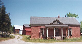
Tamworth, patented 1728, is an historical hamlet in Cumberland County, Virginia, United States, centered along Tamworth Road. In addition to farming, a gristmill and broad-crested weir on Muddy Creek comprised the principal economic activity. In addition to the mill, there are several other structures of historical interest dating from the 18th and 19th centuries: the miller's residence; a farmhouse; barns; assorted outbuildings; a post office; and Tamworth Cottage. All of the buildings are privately owned and are shown by appointment only.
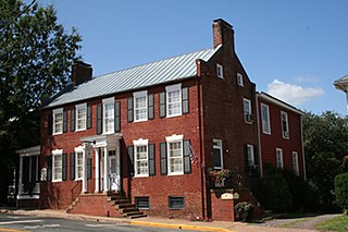
Formerly called the Doctor Holladay House, the Holladay House in Orange, Virginia is on the nationally recognized Journey Through Hallowed Ground. Named for Dr. Lewis Holladay, a prominent Virginia physician, the Holladay House has witnessed almost two centuries of American history. The building is historically significant because it is one of only a few antebellum structures still standing in Orange, Virginia.

Todd is an unincorporated community straddling the county lines of Watauga and Ashe counties in northwestern North Carolina, United States on the South Fork of the New River. It lies at an elevation of 2,992 feet. The population was 2,141 at the 2010 United States Census. The ZIP Code for Todd is 28684.
Cumberland is a small unincorporated community located within Maurice River Township in Cumberland County, in the U.S. state of New Jersey. For statistical purposes, Cumberland and neighboring Hesstown together comprise the Cumberland-Hesstown census-designated place.

Bledsoe Creek State Park is a state park in Sumner County, Tennessee, in the southeastern United States. The park consists of 169 acres (0.68 km2) managed by the Tennessee Department of Environment and Conservation. The park spans much of the west shore of the Bledsoe Creek embayment of Old Hickory Lake, an impoundment of the Cumberland River created with the completion of Old Hickory Dam by the U.S. Army Corps of Engineers in 1954.
Howardsville is an unincorporated community in Albemarle County, Virginia.

Grace Church is an Episcopal church in Cumberland County, Virginia. Designed by Dabney Cosby, a former assistant to Thomas Jefferson, it is the only substantial building remaining from the former community of Ca Ira. For its architectural and historical significance, Grace Church was listed on the National Register of Historic Places on October 30, 1980.

Dabney Cosby was an American architect, slaveowner, and builder active primarily in Virginia and North Carolina. His earliest known work dates to the 1820s; he is known to have been active until the time of his death.

"Mount Winans" is a mixed-use residential, commercial and industrial neighborhood in the southwestern area of the City of Baltimore in Maryland. Its north, south and east boundaries are marked by the various lines of track of the CSX Railroad. In addition, Hollins Ferry Road running to the south towards suburban Baltimore County in the southwest and further connecting with adjacent Anne Arundel County to the southeast, draws its western boundary.

Fifth Street Historic District is a national historic district located at Lynchburg, Virginia. The district encompasses 57 contributing buildings and 1 contributing object in a historically African-American section of Lynchburg. It includes a variety of residential, commercial, and institutional buildings, with about half dating to the period spanning from 1875 to 1940. Located in the district are the separately listed Kentucky Hotel, the Western Hotel, the William Phaup House, and the Pyramid Motors building. Other notable buildings include the Augustine Leftwich House, tobacco factories (1877-1885), the Humbles Building (1915), M.R. Scott Meat Market (1919), Miller Tire and Battery Company (1927), Adams Motor Company building (1927), Hoskins Pontiac (1951), Burnett Tire Company (1956), Moser Furniture Company building (1936), Fifth Street Baptist Church (1929), Community Funeral Home (1922), and Tal-Fred Apartments (1940).
