The English River is a tributary of the Iowa River in southeastern Iowa in the United States. The main stem of the river is 37.4 miles (60.2 km) long. Including its longest headwaters tributary, the North English River, the total length increases to 89.2 miles (143.6 km). Via the Iowa River, it is part of the Mississippi River watershed. The Deep River is a minor tributary of the English River. The towns of North English, South English and Deep River are named for the English and Deep rivers.

The Whetstone River is a 12.7-mile-long (20.4 km) tributary of the Minnesota River in northeastern South Dakota and a very small portion of western Minnesota in the United States. Via the Minnesota River, it is part of the watershed of the Mississippi River.

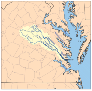
The Pamunkey River is a tributary of the York River, about 93 miles (150 km) long, in eastern Virginia in the United States. Via the York River it is part of the watershed of Chesapeake Bay.

The North Anna River is a principal tributary of the Pamunkey River, about 62 miles (100 km) long, in central Virginia in the United States. Via the Pamunkey and York rivers, it is part of the watershed of Chesapeake Bay. The river was the site of the Battle of North Anna during the American Civil War.
The South Anna River is a principal tributary of the Pamunkey River, about 102 miles (164 km) long, in central Virginia in the United States. Via the Pamunkey and York rivers, it is part of the watershed of Chesapeake Bay.
The Newfound River is a 22.1-mile-long (35.6 km) tributary of the South Anna River in east-central Virginia in the United States. Via the South Anna, Pamunkey and York rivers, it is part of the watershed of Chesapeake Bay.

The Pedlar River is a 33.9-mile-long (54.6 km) tributary of the James River in west-central Virginia in the United States. Via the James River, it is part of the watershed of Chesapeake Bay.
The Hardware River is a 23.3-mile-long (37.5 km) tributary of the James River in central Virginia in the United States. It is part of the watershed of Chesapeake Bay.
The Mechums River is a 25.5-mile-long (41.0 km) tributary of the South Fork of the Rivanna River in central Virginia in the United States. Via the Rivanna and James rivers, it is part of the watershed of Chesapeake Bay.
The Moormans River is a 14.3-mile-long (23.0 km) tributary of the South Fork of the Rivanna River in central Virginia in the United States. Via the Rivanna and James rivers, it is part of the watershed of Chesapeake Bay.
The Doyles River is a 10.1-mile-long (16.3 km) tributary of the Moormans River in central Virginia in the United States. Via the Moormans, Rivanna and James rivers, it is part of the watershed of Chesapeake Bay.
The Rockfish River is a 28.7-mile-long (46.2 km) tributary of the James River in central Virginia in the United States. Via the James River, it is part of the watershed of the Chesapeake Bay.

The Buffalo River is a 68.7-mile-long (110.6 km) left-tributary of the Mississippi River in western Wisconsin in the United States.

The Embarras River is a 195-mile-long (314 km) tributary of the Wabash River in southeastern Illinois in the United States. The waters of the Embarras reach the Gulf of Mexico via the Wabash, Ohio, and Mississippi Rivers. The river drains a watershed around 1,566,450 acres (6,339.2 km2) in an agricultural region. The name comes from French explorers, who used the term embarras for river obstacles, blockages, and difficulties relating to logjams and the like.
The Plum River is a tributary of the Mississippi River, about 46.6 miles (75.0 km) long, in northwestern Illinois in the United States. It rises in Jo Daviess County and flows generally south-southwestwardly into Carroll County, where it joins the Mississippi at Savanna. Among its several short tributaries are:

The Rough River is a 156-mile-long (251 km) tributary of the Green River in west-central Kentucky in the United States. Via the Green and Ohio rivers, it is part of the watershed of the Mississippi River. According to the Geographic Names Information System, it has also been known historically as "Rough Creek".
The Pond River is a 90.8-mile-long (146.1 km) tributary of the Green River in western Kentucky in the United States. Via the Green and Ohio rivers, it is part of the watershed of the Mississippi River.

The Nolin River is a 104-mile-long (167 km) tributary of the Green River in central Kentucky in the United States. Via the Green and Ohio rivers, it is a part of the watershed of the Mississippi River.
The Little Willis River is a 15.5-mile-long (24.9 km) tributary of the Willis River in the U.S. state of Virginia. It is part of the James River watershed. It rises in Buckingham County and flows east into Cumberland County, joining the Willis River 9 miles (14 km) north of Farmville.
The Piney River is a 16.5-mile-long (26.6 km) tributary of the Tye River in the U.S. state of Virginia. It is part of the James River watershed.

DeLorme is a producer of personal satellite tracking, messaging, and navigation technology. The company’s main product, inReach, integrates GPS and satellite technologies. inReach provides the ability to send and receive text messages anywhere in the world by using the Iridium satellite constellation. By pairing with a smart phone, navigation is possible with access to free downloadable topographic maps and NOAA charts. On February 11, 2016, the company announced that it had been purchased by Garmin, a multinational producer of GPS products and services.

The International Standard Book Number (ISBN) is a numeric commercial book identifier which is intended to be unique. Publishers purchase ISBNs from an affiliate of the International ISBN Agency.


