Cad. FAP Guillermo del Castillo Paredes Airport

Last updated
Cad. FAP Guillermo del Castillo Paredes Airport
Summary
Airport typePublic
Operator ADP
Location Tarapoto
Elevation  AMSL 868 ft / 265 m
Coordinates 6°30′30″S76°22′25″W / 6.50833°S 76.37361°W / -6.50833; -76.37361 Coordinates: 6°30′30″S76°22′25″W / 6.50833°S 76.37361°W / -6.50833; -76.37361
Map
Peru location map.svg
Airplane silhouette.svg
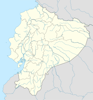
TPP
Location of the airport in Peru
Runways
Direction LengthSurface
mft
17/352,2557,398Asphalt
Sources: GCM [1] Google Maps [2]

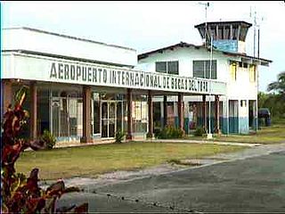
Cadete FAP Guillermo del Castillo Paredes Airport( IATA : TPP, ICAO : SPST) is an airport serving Tarapoto, Peru. It is owned by CORPAC S.A, a government organization that oversees the management of Peruvian airports, but it is run by Aeropuertos del Perú (ADP) S.A, as a concession. It is the main airport of the San Martín Region, located in the Amazon, and is used by many tourists as a jumping-off point for trips into the jungle. The airport is currently served by LAN Perú, Star Peru, and TACA Perú.

An IATA airport code, also known as an IATA location identifier, IATA station code or simply a location identifier, is a three-letter code designating many airports around the world, defined by the International Air Transport Association (IATA). The characters prominently displayed on baggage tags attached at airport check-in desks are an example of a way these codes are used.

ICAO airport code four-letter code designating many airports around the world

The ICAOairport code or location indicator is a four-letter code designating aerodromes around the world. These codes, as defined by the International Civil Aviation Organization and published in ICAO Document 7910: Location Indicators, are used by air traffic control and airline operations such as flight planning.

Airport location where aircraft take off and land

An airport is an aerodrome with extended facilities, mostly for commercial air transport. Airports often have facilities to store and maintain aircraft, and a control tower. An airport consists of a landing area, which comprises an aerially accessible open space including at least one operationally active surface such as a runway for a plane to take off or a helipad, and often includes adjacent utility buildings such as control towers, hangars and terminals. Larger airports may have airport aprons, taxiway bridges, air traffic control centres, passenger facilities such as restaurants and lounges, and emergency services. In some countries, the US in particular, they also typically have one or more fixed-base operators, serving general aviation.

Contents

The runway length of 2,255 metres (7,398 ft) does not include a 350 metres (1,150 ft) displaced threshold on the northern end.

The Tarapoto non-directional beacon (Ident: TAP) is located on the field. [3] The Tarapoto VOR-DME (Ident: TAP) is located 9.0 nautical miles (16.7 km) south of the airport. [4]

Non-directional beacon radio transmitter which emits radio waves in all directions

A non-directional (radio) beacon (NDB) is a radio transmitter at a known location, used as an aviation or marine navigational aid. As the name implies, the signal transmitted does not include inherent directional information, in contrast to other navigational aids such as low frequency radio range, VHF omnidirectional range (VOR) and TACAN. NDB signals follow the curvature of the Earth, so they can be received at much greater distances at lower altitudes, a major advantage over VOR. However, NDB signals are also affected more by atmospheric conditions, mountainous terrain, coastal refraction and electrical storms, particularly at long range.

Airlines and destinations

AirlinesDestinations
Saeta Perú Chachapoyas, Yurimaguas, Iquitos, Pucallpa,Ciro Alegria, San Lorenzo, Galilea [5]
LATAM Perú Lima
Seasonal: Iquitos
Movil Air Chachapoyas, Chiclayo, Trujillo [6]
Peruvian Airlines Lima
Sky Airline Lima (begins April 15th) [7]
Star Perú Iquitos, Lima
Seasonal: Pucallpa

See also

Related Research Articles

Inca Manco Cápac International Airport airport

Inca Manco Cápac International Airport, known as Aeropuerto Internacional Inca Manco Cápac in Spanish, is an extremely high elevation airport serving in the city of Juliaca, 32 kilometres (20 mi) west of Titicaca Lake. Airport operations are run by Corporación Peruana de Aeropuertos y Aviación Comercial S.A. (CORPAC), the government entity that oversees management of Peruvian airports. Despite being classified as international, Inca Manco Cápac International Airport does not feature any scheduled international nonstop flights. The airport has one of the longest runways in Latin America.

Rodríguez Ballón International Airport airport

Rodríguez Ballón International Airport, known as Aeropuerto Internacional Rodríguez Ballón in Spanish, is an airport serving Arequipa, the capital of Arequipa Region and Peru's second largest city. This airport and Cusco's Alejandro Velasco Astete International Airport are the main air hubs in southern Peru. It is named after a famous Aviation pilot.

Coronel FAP Francisco Secada Vignetta International Airport airport

Coronel (Crnl.) FAP Francisco Secada Vignetta International Airport is an airport serving Iquitos, capital of Loreto Region and Peru's fifth largest city. Iquitos and Pucallpa are the main air hubs in the Peruvian Amazon.

FAP Captain David Abensur Rengifo International Airport Airport in Pucallpa, Coronel Portillo, Ucayali, Peru

FAP Captain David Abensur Rengifo International Airport is an airport serving the city of Pucallpa in the Ucayali Region of Peru. It is operated by Aeropuertos del Perú, S.A. Captain Rengifo Airport is the main airport serving the Ucayali Region.

Coronel FAP Carlos Ciriani Santa Rosa International Airport airport in Peru

Coronel FAP Carlos Ciriani Santa Rosa International Airport is an airport serving Tacna, Peru. It is run by CORPAC S.A., a government organization that oversees airport management. The airport is the main airport of the Tacna Region, and is 27 km (17 mi) north of Peru's border with Chile.

Cap. FAP Pedro Canga Rodríguez Airport Tumbes

Capitán FAP Pedro Canga Rodríguez Airport is an airport serving Tumbes, Peru. It is the main airport of the Tumbes Region, and is run by CORPAC S.A., a government organization that manages Peruvian airports. The airport is used mainly by locals and national and international travelers because of its proximity to beaches and resorts.

FAP Captain Carlos Martínez de Pinillos International Airport airport in Trujillo, Peru

Capitán FAP Carlos Martínez de Pinillos International Airport, known as Aeropuerto Internacional Capitán FAP Carlos Martínez de Pinillos in Spanish, is an airport serving Peru's third largest city, Trujillo, as well as the beach community of Huanchaco. It is the main air hub in northern Peru.

FAP Captain Guillermo Concha Iberico International Airport airport

Capitán FAP Guillermo Concha Iberico International Airport is an airport serving Piura, Peru. It is run by ADP a private operator that manages various airports in northem Peru. It is the main airport of the Piura Region, the second most populous one of the country. It is currently served by LATAM Perú, Peruvian Airlines, Sky Airline and Viva Air Perú; and is 2 kilometres (1.2 mi) from Piura's main square and 130 kilometres (81 mi) from the famous Máncora resort.

Wayraperú is an airline based at Jorge Chávez International Airport in Lima, Perú, that operated between March and November 2006, then again since May 2018. In January 2018 the carrier announced the intention to recommence services.

Bocas del Toro "Isla Colón" International Airport airport

Bocas del Toro "Isla Colón" International Airport is a public airport located 1.5 kilometres (1 mi) northwest of the center of Bocas del Toro, a town on Isla Colón in the Bocas del Toro Province of Panama.

Cotopaxi International Airport

Cotopaxi International Airport is a high elevation airport in Latacunga, the capital of the Cotopaxi Province in Ecuador. The airport is within a broad valley of the Ecuadoran Andes, with rising terrain east and west, and mountainous terrain distant in all quadrants.

El Loa Airport

El Loa Airport, is the major airport serving Calama, a city in the Antofagasta Region of Chile. It is one of the largest airports in Chile.

Jorge Enrique González Torres Airport airport serving San José del Guaviare, the capital of the Guaviare Department of Colombia

Jorge Enrique González Torres Airport is an airport serving San José del Guaviare, the capital of the Guaviare Department of Colombia. The runway is just north of the town and parallels the Guaviare River.

Barinas Airport airport

Barinas Airport is an airport serving Barinas, the capital of the Venezuelan state of Barinas.

Las Flecheras Airport airport in Venezuela

Las Flecheras Airport is an airport serving the city of San Fernando de Apure, the capital of the Apure state in Venezuela. The runway is just east of the city, along the Apure River.

Chachapoyas Airport airport in Peru

Chachapoyas, is an airport serving the city of Chachapoyas in the Amazonas Region of Peru. The runway is on a mesa north of the city, with steep dropoffs on either end.

Ilo Airport Airport in Peru

Ilo Airport is an airport in the Moquegua Region of Peru serving the city of Ilo. The runway is on the Pacific shoreline 4 kilometres (2.5 mi) south of the city.

Changuinola "Capitán Manuel Niño" International Airport airport in Panama

Changuinola "Capitan Manuel Niño" International Airport is an airport serving Changuinola, the capital of the Changuinola District in the Bocas del Toro Province in Panama. The name is in honor of the first Panamanian pilot.

Uyuni Airport airport

Uyuni Airport, also known as Joya Andina Airport, is an airport at extremely high elevation just northwest of Uyuni, in the southwestern Potosí Department of Bolivia. It is close to the Salar de Uyuni, the world's largest salt flat. It was opened by the Bolivian president Evo Morales on July 11, 2011. Currently the airport is served by three airlines: Amaszonas, Boliviana de Aviacion and TAM – Transporte Aéreo Militar, which offer regular flights to and from Sucre, La Paz and Santa Cruz de la Sierra.

Quintero Airport, is an airport serving Quintero, a Pacific coastal city in the Valparaíso Region of Chile.

References

The Aviation Safety Network (ASN) is a website that keeps track of aviation accidents, incidents, and hijackings. Their database contains details of over 10,700 reports. The ASN includes an aviation database with aviation investigations, news, photos, and statistics.