Kuwaykat, also spelled Kuweikat, Kweikat or Kuwaikat, was a Palestinian village located 9 km northeast of Acre. It was depopulated in 1948.

Rosh HaAyin is a city in the Central District of Israel. In 2022, it had a population of 73,678.

A concentric castle is a castle with two or more concentric curtain walls, such that the outer wall is lower than the inner and can be defended from it. The layout was square where the terrain permitted, or an irregular polygon where curtain walls of a spur castle followed the contours of a hill.
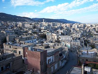
Masyaf is a city in northwestern Syria. It is the center of the Masyaf District in the Hama Governorate. As of 2004, Masyaf had a religiously diverse population of approximately 22,000 Ismailis, Alawites and Christians. The city is well known for its large medieval castle, particularly its role as the headquarters of the Nizari Ismailis and their elite Assassins unit.

A watchtower or watch tower is a type of fortification used in many parts of the world. It differs from a regular tower in that its primary use is military and from a turret in that it is usually a freestanding structure. Its main purpose is to provide a high, safe place from which a sentinel or guard may observe the surrounding area. In some cases, non-military towers, such as religious towers, may also be used as watchtowers.
Kafr Kanna is an Arab town in the Galilee, part of the Northern District of Israel. It is associated by Christians with the New Testament village of Cana, where Jesus turned water into wine. In 2022 its population was 24,108. It has a religiously mixed population of Muslims and Christians from different denominations.
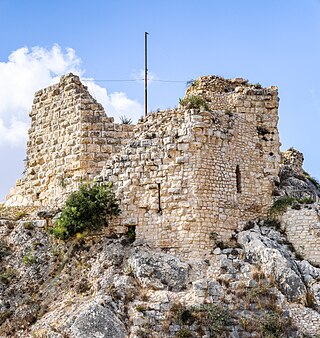
Beaufort or Belfort Castle, known locally as Qal'at al-Shaqif or Shaqif Arnun, is a Crusader fortress in Nabatieh Governorate, Southern Lebanon, about 1 kilometre (0.62 mi) to the south-south-east of the village of Arnoun. There was a fortification on the site before it was captured by Fulk, King of Jerusalem, in 1139 and construction of the Crusader castle probably began soon after. Saladin captured Beaufort in 1190, but 60 years later Crusaders re-took it. In 1268 Sultan Baibars finally captured the castle for the Islamic forces.

Kafr Yasif is an Arab town in the Northern District of Israel. It is located 11 kilometers (6.8 mi) northeast of the city of Acre and adjacent to Abu Sinan and Yarka. The population of Kafr Yasif is half Christian (52.1%) with the rest Muslim (44.9%), and a small Druze community.

Qaqun was a Palestinian Arab village located 6 kilometers (3.7 mi) northwest of the city of Tulkarm at the only entrance to Mount Nablus from the coastal Sharon plain.

HaBonim is a moshav shitufi in northern Israel. Located 5 km south of Atlit and 3 km north of Kibbutz Nahsholim, it falls under the jurisdiction of Hof HaCarmel Regional Council. In 2022 it had a population of 383.

Armanaz is a town in northwestern Syria, administratively part of the Harem District, in the Idlib Governorate. It is located 20 kilometers northwest of Idlib near the Syrian-Turkish borders. Nearby localities include Salqin, Harem and Kafr Takharim to the north and Idlib, Ma'arrat Misrin and Saraqib to the southeast.

Parod is a kibbutz in northern Israel. Located in the Upper Galilee near Safed, it falls under the jurisdiction of Merom HaGalil Regional Council. In 2022 it had a population of 621.

Matzuva, also known as Metzuba, is a kibbutz in the Western Galilee in northern Israel. Located to the south of the development town of Shlomi, it falls under the jurisdiction of Mateh Asher Regional Council. In 2022 it had a population of 1,163.

Kafr Lam was a Palestinian Arab village located 26 kilometres (16 mi) south of Haifa on the Mediterranean coast. The name of the village was shared with that of an Islamic fort constructed there early in the period of Arab Caliphate rule in Palestine. To the Crusaders, both the fort and the village, which they controlled for some time in the 13th century, were known as Cafarlet.

The Tower of Flies was a formidable guard tower/fort at the medieval city-port of Acre, Israel, which overlooked the harbour from a small island and protected the city's rich maritime trade. It also served as a lighthouse.
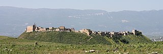
Qalaat al-Madiq is a town and medieval fortress in northwestern Syria, administratively part of the Hama Governorate, located northeast of Hama. It is situated in the al-Ghab plain, on the eastern bank of the Orontes River. Nearby localities include the district center al-Suqaylabiyah to the south, Bureij and Karnaz to the southeast, Kafr Nabudah to the east, al-Huwash to the north, Huwayjah al-Sallah and Shathah to the northwest and Al-Tuwayni and Ennab to the west. According to the Syria Central Bureau of Statistics (CBS), Qalaat al-Madiq had a population of 12,925 in the 2004 census. It is the administrative center and second largest locality in the Qalaat al-Madiq nahiyah ("subdistrict") which consisted of 40 localities with a collective population of 85,597 in 2004. The town's inhabitants are predominantly Sunni Muslims.

Tel Yokneam, also spelled Yoqne'am or Jokneam, is an archaeological site located in the northern part of the modern city of Yokneam Illit, Israel. It is known in Arabic as Tell Qamun, believed to be a corruption of the Hebrew name. The site is an elevated mound, or tell, spanning around 40 dunams and rising steeply to a height of 60 meters (200 ft). With a few brief interruptions, Yokneam was occupied for 4,000 years, from the Middle Bronze Age to the Ottoman period.

Bersabe, also known as Beersheba of Galilee, was a Second Temple period Jewish village located near the town of Kefar Hananya which marked the boundary between the Upper Galilee and the Lower Galilee, as described by Josephus, with Upper Galilee stretching from Bersabe in the Beit HaKerem Valley to Baca (Peki'in) in the north. Bersabe was one of several towns and villages of Galilee fortified by Josephus during the First Jewish–Roman War, being one of the most defensible positions and where insurgents from across Galilee had taken up refuge against the Imperial Roman army when the surrounding countryside was plundered.