
Qula was a Palestinian village in the Ramle Subdistrict of Mandatory Palestine, located 15 km northeast of Ramla. Its residents had their origins in Jimzu, Ammuriya and other places.

Kudna was a Palestinian Arab village, located 25 kilometers northwest of Hebron.

Rantiya was a Palestinian village, located 16 kilometers east of Jaffa. During the British Mandate in Palestine, in 1945 it had a population of 590 inhabitants.

Deir Abu Mash'al is a Palestinian village in the Ramallah and al-Bireh Governorate of the State of Palestine, located 24 kilometers (15 mi) west of Ramallah in the northern West Bank. According to the Palestinian Central Bureau of Statistics (PCBS), the village had a population of 4,233 inhabitants in 2017.

Ein Siniya is a small Palestinian village in the Ramallah and al-Bireh Governorate, 10 kilometers (6.2 mi) north of Ramallah, and approximately 1km northeast from Jifna. It lies in a valley surrounded with olive and fig-terraces.

Karatiyya was a Palestinian Arab village of 1,370, located 29 kilometers (18 mi) northeast of Gaza, situated in a flat area with an elevation of 100 meters (330 ft) along the coastal plain of Palestine and crossed by Wadi al-Mufrid.

Salbit was a Palestinian Arab village located 12 kilometers (7.5 mi) southeast of al-Ramla. Salbit was depopulated during the 1948 Arab–Israeli War after a military assault by Israeli forces. The Israeli locality of Shaalvim was established on the former village's lands in 1951.

Summil was a Palestinian Arab village in the Gaza Subdistrict, located 36 kilometers (22 mi) northeast of Gaza. It was situated on a sandy hill in the coastal plain and had a population of 950 in 1945. It was depopulated during the 1948 Arab-Israeli War.
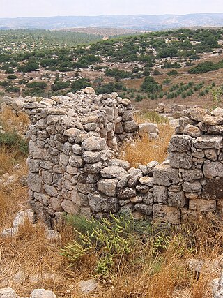
Khirbat Umm Burj was a Palestinian Arab village in the Hebron Subdistrict, sometimes designated in modern maps as Burgin. Its ruins are today located within the borders of Israel. It occupied an extensive site, stretching about 30 dunams on the crest of a hill, rising some 430 metres (1,410 ft) above sea level, and commanding a good prospect of the surrounding region. It was depopulated during the 1948 Arab–Israeli War on October 28, 1948, during the third stage of Operation Yo'av under the command of Yigal Allon. The site is located 17 km northwest of Hebron.

Al-Safiriyya was a Palestinian Arab village in the Jaffa Subdistrict. It was depopulated during Operation Hametz in the 1948 Palestine War on May 20, 1948. It was located 11 km east of Jaffa, 1.5 km west of Ben Gurion Airport.

Sufla was a Palestinian Arab village in the Jerusalem Subdistrict. It was depopulated during the 1948 Arab–Israeli War on October 19, 1948, by the Sixth Battalion of the Harel Brigade under Operation Ha-Har. It was located 18.5 km west of Jerusalem.

Barfiliya was a Palestinian village located 10.5 kilometres (6.5 mi) east of Ramla that was depopulated during the 1948 Arab–Israeli War. Located on a tell, excavations conducted there by Israeli archaeologists beginning in 1995 found artifacts dating back to the Pre-Pottery Neolithic A (PPNA) period.
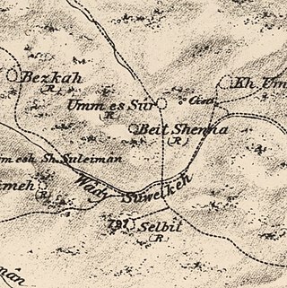
Bayt Shanna was a Palestinian Arab village in the Ramle Subdistrict of Mandatory Palestine. It was depopulated during the 1948 Arab–Israeli War on July 15, 1948, during the second stage of Operation Dani. It was located 11.5 km southeast of Ramla.

Bir Ma'in was a Palestinian Arab village in the Ramle Subdistrict. It was depopulated during the 1948 Arab-Israeli War on July 15, 1948 during the second phase of Operation Danny by the First and Second Battalions of the Yiftach Brigade. It was located 14 km east of Ramla. The village was defended by the Jordanian Army.

Dayr Tarif was a Palestinian Arab village in the Ramle Subdistrict of Mandatory Palestine. It was depopulated during the 1948 Arab-Israeli War on July 10, 1948.

Al-Haditha was a Palestinian village in the Ramle Subdistrict. It was located 8 km northeast of Ramla, on the bank of Wadi al-Natuf. The site, now known as Tel Hadid, has yielded significant archaeological remains from many periods. Al-Haditha was depopulated during the 1948 Arab-Israeli War on July 12, 1948, under the first stage of Operation Dani.
Khulda, also Khuldeh, was a Palestinian Arab village located 12 kilometers (7.5 mi) south of Ramla in the Mandatory Palestine. Known as Huldre to the Crusaders, it is also mentioned in documents dating to the periods of Mamluk, Ottoman, and Mandatory rule over Palestine. During the 1948 war, the village was depopulated as part of Operation Nachshon and was subsequently destroyed. The Israeli kibbutz of Mishmar David was established that same year on land belonging to the village.

Al-Kunayyisa was a small Palestinian Arab village in the Ramle Subdistrict. It was depopulated during the 1948 Arab–Israeli War on July 10, 1948, under the first stage of Operation Dani. It was located 12 km southeast of Ramla.

Al-Qubab was a Palestinian Arab village in the Ramle Subdistrict. It was depopulated in July 1948 during the Operation Dani led by the Yiftach Brigade.

Sarafand al-Kharab was a Palestinian Arab village in the Ramle Subdistrict, located 50 meters (160 ft) above sea level, 7 kilometers (4.3 mi) west of Ramla, in the area that is today northeast of Ness Ziona.
 1870s map
  1940s map
 modern map
 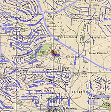 1940s with modern overlay map


