Hawsha (Arabic: هوشة, Hǔsheh, also Husha) was an Arab village established in 1880 by Maghrebi immigrants of Algerian origin, built on ruins of the ancient Jewish town Usha.[7][8] The place is located 13 kilometers (8.1mi) east of Haifa, about 100 meters (330ft) above sea level.
In 1945, it had a population of 580 inhabitants, 400 of whom were ArabMuslims and 180 of whom were Jewish. The built-up area of the village was 50 dunums, and 717 dunums were used for agriculture. All but 7 dunums of public land were owned by Jews by this time.[4]
The village was located on a low hilly area between the plain of Haifa and Marj ibn Amr (Jezreel Valley) and situated on an east–west axis. To the west lay a wide valley, Wadi Husheh, that was the dividing area between it and the neighboring village of Khirbat al-Kasayir.[4][12]
History
Israelite city: unlikely
19th-century researchers have connected Hawsha to the biblical village of Hosah (Chossah), a border settlement of the Israelitetribe of Asher.[4] More recently, this biblical city tends to be identified with archaeogical sites closer to Tyre.[13]
Hawsha was mentioned as part of the domain of the Crusaders during the hudna between the Crusaders based in Acre and the Mamluk sultan al-Mansur Qalawun, declared in 1283.[15]
Ottoman period: shrine, ancient ruins, well
Under the rule of the Ottoman Empire, the lands at Hawsha belonged to the inhabitants of Shefa 'Amr. The site contained many ancient ruins, parts of which were used to build some structures, including a shrine known as Maqam Nabi Hushan, a well (Bir Husheh), and tombstones.[4][16]William M. Thomson, writing in 1859, identifies the shrine as Neby Hǔshǎ, which he translates as the "Prophet Joshua," and describes it as a "white-domed mazar [...] a place of great resort."[1] In the Survey of Western Palestine (SWP; 1838), it is noted that the Prophet Hosea is said to be buried near "Kh. Husheh."[10][i] Also in the village was a mosaic floor from an ancient building.[4]
V. Guérin, who visited the site in 1875, provides a lengthy description of the ancient ruins in evidence throughout the area. He states his belief that this is the site of ancient Usha and speculates that the ruins of a finely built edifice, in which there are the remnants of many columns, was a synagogue. He then says a synagogue of Ousha should be constructed if there is not already such a place of worship in the vicinity. Also noting the presence of the domed wali of Neby Houchan consecrated to the prophet Hosea, he cites the Muslim tradition that this prophet is here interred. He describes the shrine as being constructed of what appear to be ancient stones, with what seems to be a mihrab at its base, noting there are shreds of clothing strewn and floating about it.[17]
In an 1890 quarterly statement for the PEF, the ancient ruins of Hawsha are described as follows: "This ruin [...] must have been an important place, to judge from the mass of building stones and the fragments of columns lying about. Now that the grass is dried up a regular city wall can be traced. On the main road running from the well towards the ruin some fine capitals are lying about, which have a close resemblance to those which on other sites have been stated to be remains of synagogues. The shafts of columns lying about generally have the basis or capital worked out of the same piece, have a diameter of 18inches, and are composed of Nari limestone."[18]
In the same report, it is noted that the water of Bir Husheh, located at the western edge of the ruin, is praised by the locals for its "excellence." Older inhabitants relayed how Jezzar Pasha and Abdullah Pasha, former governors of 'Acca, had their drinking water supplied from the well, and tended to camp by the well during their trips to the interior.[18] Also mentioned in the report is a Greek-language inscription found on a flat stone 508 meters (1,667ft) to the east of the eastern city wall of the ancient city and 100 meters (330ft) to the west of a small olive grove, in a rocky region just to the south of a road leading to Shefa 'Amr. The inscription was discovered by natives of Shefa 'Amr who showed it to a priest from Beirut, who in turn shared it with Gottlieb Schumacher of the PEF.[18]
Hawsha was categorized as a hamlet in the Mandate-period Palestine Index Gazetteer. The houses were clustered around the water cistern at the center of the village. The Muslim inhabitants shared a cemetery with Khirbat al-Kasayir. The villagers were agriculturalists and pastoralists who raised livestock. Beans were the most important agricultural product. The agricultural area of the village lay to the southwest. A small area north of the built-up part of the village was planted with olive and fruit trees.[4]
In 1937, KibbutzUsha was established 2 kilometers (1.2mi) west of Hawsha.[4]
Nabi Hushan shrine in the cemetery that was used by the villagers of Hawsha and al-Kayasir.
Plaque over the doorway of the entrance to shrine. It reads: "Shrine of the Prophet Hushan, peace be upon him."
Part of the interior of the Nabi Hushan shrine. The chalkboard message on the right reads: "O ye inside this house [of prayer], pray to the Chosen Prophet [i.e. Muhammad]."
1948 war and aftermath
On 11 April 1948, Fawzi al-Qawuqji ordered the ALA's Druze Battalion to begin operations around Kibbutz Ramat Yohanan. The Battalion occupied the semi-abandoned villages of Hawsha and Khirbat al-Kasayir and began to shell Ramat Yohanan and harass the neighboring settlements.[24] The Haganah responded and on the night of 15–16 April, what is known as the Battle of Ramat Yohanan, after the Jewish settlement bloc close to where it was fought, also known by Palestinian historians as the 'Battle of al-Husha and al-Kayasr'[dubious–discuss], after the Palestinian villages that were conquered by the Haganah forces by the battle's end, ensued.[4][25] According to Morris, "Wailing refugees fled to Shafa-Amr, spreading rumors of Jewish atrocities".[24] According to Benvenisti, the Arab inhabitants who remained in the village following its conquest were evicted in the months following the end of the 1948 Arab-Israeli war, as were the inhabitants of neighboring villages whose lands were coveted for Jewish settlement.[26]
A volunteer effort to restore the cemetery of the depopulated village of Hawsha was undertaken in 1994 and overseen by the Al-Aqsa Association of the Islamic Movement in Israel.[27]
Hawsha-al-Kayasir cemetery
A view of the cemetery shared by the villages of Hawsha and al-Kayasir prior their depopulation.
Another view of the cemetery.
Arabic inscription of a headstone for a grave in the cemetery which reads: "In the name of God, Most Gracious, Most Merciful ... Il-Marhoum ('the mercifully departed') Hussein Abid [last name unclear] 1175 12 17."
Footnotes
i.
^Hoshea or Hosea is used to refer to different biblical characters: Joshua, whose name was changed from Hoshea/Hosea ("salvation") to Joshua ("Yahweh is salvation") by Moses; Hosea, the prophet mentioned in the Book of Hosea; and Hoshea, ruler of the Kingdom of Israel.[28][29]
↑ (all but 7 dunums was owned by Jews by 1944-45) Government of Palestine, Department of Statistics. Village Statistics, April, 1945. Quoted in Hadawi, 1970, p. 49
1 2 Government of Palestine, Department of Statistics, 1945, p. 15
Zunz, L. (1841). "On the geography of Palestine from Jewish sources". In Adolf Asher[de] (ed.), The itinerary of Rabbi Benjamin of Tudela, Volume 2. Berlin: Julius Sittenfeld[de] printing house. p. 428. ISBN1-152-34804-3. Access date 29 January 2024.
This page is based on this Wikipedia article Text is available under the CC BY-SA 4.0 license; additional terms may apply. Images, videos and audio are available under their respective licenses.
 Nabi Hushan shrine in the cemetery that was used by the villagers of Hawsha and al-Kayasir.
 Plaque over the doorway of the entrance to shrine. It reads: "Shrine of the Prophet Hushan, peace be upon him."
 Part of the interior of the Nabi Hushan shrine. The chalkboard message on the right reads: "O ye inside this house [of prayer], pray to the Chosen Prophet [i.e. Muhammad]."
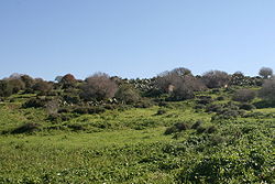
 1870s map
  1940s map
 modern map
  1940s with modern overlay map


