Dayr Tarif

Last updated
Dayr Tarif
دير طريف
Deir Tarif
IL Beit Arif.jpg
Dayr Tarif remains
Etymology: The monastery of Tureif ("the end") [1]
Historical map series for the area of Dayr Tarif (1870s).jpg 1870s map
Historical map series for the area of Dayr Tarif (1940s).jpg 1940s map
Historical map series for the area of Dayr Tarif (modern).jpg modern map
Historical map series for the area of Dayr Tarif (1940s with modern overlay).jpg 1940s with modern overlay map
A series of historical maps of the area around Dayr Tarif (click the buttons)
Mandatory Palestine location map.svg
Red pog.svg
Dayr Tarif
Location within Mandatory Palestine
Coordinates: 31°59′33″N34°56′23″E / 31.99250°N 34.93972°E / 31.99250; 34.93972
Palestine grid 144/155
Geopolitical entity Mandatory Palestine
Subdistrict Ramle
Date of depopulationJuly 10, 1948 [2]
Population
 (1948)
  Total1,750 [3] [4]
Cause(s) of depopulationMilitary assault by Yishuv forces
Current Localities Beit Arif [5]

Dayr Tarif was a Palestinian Arab village in the Ramle Subdistrict of Mandatory Palestine. It was depopulated during the 1948 Arab-Israeli War on July 10, 1948.

Contents

History

The site is identified with Bethariph, a place mentioned in Eusebius' Onomasticon, which was composed in the early 4th century CE. [6] According to SWP; "South-west of the village are traces of ruins, cisterns, and 'rock-sunk' tombs, evidently Christian again, as connected with a monastery." [7] Ceramics from the Byzantine era have been found here. [8]

Ottoman era

Dayr Tarif, like the rest of Palestine, was incorporated into the Ottoman Empire in 1517, and in the census of 1596, the village was located in the nahiya (subdistrict) of al-Ramla under the Liwa of Gaza, with a population of 49 households, an estimated 270 persons, all Muslim. They paid a fixed tax rate of 25% on agricultural products, including wheat, barley, summer crops, vineyards, fruit trees, sesame, goats and beehives, in addition to occasional revenues; a total of 9,000 akçe. [9]

According to Marom, in the 18th or early 19th centuries, residents of Qibya affiliated with the Yamani camp during the Qays and Yaman conflicts, alongside residents of Qibya and part of the residents of Bayt Nabala. They fought several skirmishes against rivals from Deir Abu Mash'al and Jayyous. [10]

In 1838 Deir Tureif was among the villages Edward Robinson noted from the top of the White Mosque, Ramla. [11]

In 1870, Victor Guérin estimated that the village had 400 inhabitants. He further noted ancient columns by the mosque. [12] An Ottoman village list from about the same year found that the village had a population of 374, in a total of 93 houses, though the population count included men, only. [13] [14]

In 1882 the PEF's Survey of Western Palestine (SWP) described the village as "A very small hamlet at the edge of the plain. This would seem to be the place called Betariph in the 'Onomasticon,' near Diospolis (Lod)." [15]

British Mandate era

In the 1922 census of Palestine conducted by the British Mandate authorities, Dayr Tarif had a population of 836; all Muslims, [16] increasing in the 1931 census to 1,246, still all Muslims, in a total of 291 houses. [17]

An elementary school was founded in 1920 and by 1947, it had 171 students. [5]

In the 1945 statistics the population was 1,750, all Muslims, [3] while the total land area was 8,756 dunams, according to an official land and population survey. [4] Of this, a total of 1,410 dunams were used for citrus and bananas, 486 dunums were plantations or irrigated, 5,989 for cereals, [18] while 51 dunams were classified as built-up public areas. [19]

1948, aftermath

Dayr Tarif was depopulated during the 1948 Arab-Israeli War on July 10, 1948, by the Ninth Commando Battalion of the Armored Brigade of Operation Dani. The village, with a population of 2,030, was defended by the Jordanian Army, but Dayr Tarif was mostly destroyed with the exception of its school, which serves as a stable. After it was conquered, the Palestinian population was expelled. The IDF asked for permission to destroy this village and a cluster of over a dozen others, after the commander Zvi Ayalon noted that they lacked sufficient manpower to occupy the area. [5] [20]

In 1992 the village site was described: "The site, covered with the debris of destroyed houses, is overgrown with thorns and other wild plants. A number of old olive and cypress trees are scattered across the site. The school building serves as a stable. Cotton and citrus are cultivated by Israelis on the surrounding lands." [5]

Related Research Articles

<span class="mw-page-title-main">Bayt Nabala</span> Place in Ramle, Mandatory Palestine

Bayt Nabala or Beit Nabala was a Palestinian Arab village in the Ramle Subdistrict in Palestine that was destroyed during the 1948 Arab–Israeli War. The village was in the territory allotted to the Arab state under the 1947 UN Partition Plan. Its population in 1945, before the war, was 2,310.

<span class="mw-page-title-main">Deir al-Dubban</span> Place in Hebron, Mandatory Palestine

Deir al-Dubban was a small Palestinian village 26 kilometers (16 mi) northwest of Hebron, near the modern village of Luzit, between Jerusalem, and Ashkelon. The village was depopulated in the 1948 Palestine War.

<span class="mw-page-title-main">Idnibba</span> Place in Ramle, Mandatory Palestine

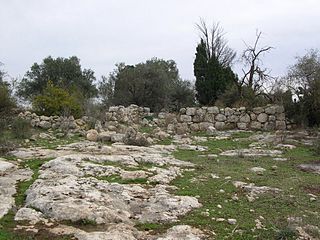
Idnibba was a Palestinian village, located at latitude 31.7426937N and longitude 34.8561001,E in the southern part of the Ramle Subdistrict. It was depopulated in 1948, at which time its population was 568, and its lands are now used by Kfar Menahem.

<span class="mw-page-title-main">Shahma</span> Village in Ramle, Mandatory Palestine

Shahma was a Palestinian Arab village located 15 kilometers (9.3 mi) southwest of Ramla. Depopulated on the eve of the 1948 Arab-Israeli war, the village lands today form part of a fenced-in area used by the Israeli Air Force.

<span class="mw-page-title-main">Al-Masmiyya al-Kabira</span> Place in Gaza, Mandatory Palestine

Al-Masmiyya al-Kabira was a Palestinian village in the Gaza Subdistrict, located 41 kilometers (25 mi) northeast of Gaza. With a land area of 20,687 dunams, the village site was situated on an elevation of 75 meters (246 ft) along the coastal plain. It was depopulated during the 1948 Arab–Israeli War. Before the war, it had a population of 2,520 in 1945.

<span class="mw-page-title-main">Dayr Sunayd</span> Place in Gaza, Mandatory Palestine

Dayr Sunayd was a Palestinian Arab village in the Gaza Subdistrict, located 12 kilometers (7.5 mi) northeast of Gaza. Situated at an elevation of 50 meters (160 ft) along the southern coastal plain of Palestine, Deir Sunayd had a total land area of 6,081 dunams. Prior to its depopulation during the 1948 Arab–Israeli War, it had 730 inhabitants in 1945.

<span class="mw-page-title-main">Barqusya</span> Place in Hebron, Mandatory Palestine

Barqusya was a Palestinian Arab village in the Hebron Subdistrict, depopulated in the 1948 Palestine War. It was located 31 km northwest of Hebron.

<span class="mw-page-title-main">Dayr Nakhkhas</span> Place in Hebron, Mandatory Palestine

Dayr Nakhkhas was a Palestinian Arab village located 20 km northwest of Hebron, overlooking Wadi Bayt Jibrin to the north.

<span class="mw-page-title-main">Mughallis</span> Village in Hebron, Mandatory Palestine

Mughallis was a Palestinian Arab village located 30.5 kilometers (19.0 mi) northwest of Hebron. It was depopulated during the 1948 Arab-Israeli War between July 9–10, 1948 as part of Operation An-Far.

<span class="mw-page-title-main">Dayr 'Amr</span> Village in Jerusalem, Mandatory Palestine

Dayr 'Amr was a Palestinian Arab village in the Jerusalem Subdistrict. It was depopulated during the 1948 Arab-Israeli War on July 17, 1948, by the Fourth Battalion of the Har'el Brigade, during the second stage of Operation Dan. It was located 12.5 km west of Jerusalem. Dayr 'Amr was named after a local sage known by al-Sa'i 'Amr and a shrine was in the village dedicated to him.

<span class="mw-page-title-main">Sufla</span> Place in Jerusalem, Mandatory Palestine

Sufla was a Palestinian Arab village in the Jerusalem Subdistrict. It was depopulated during the 1948 Arab–Israeli War on October 19, 1948, by the Sixth Battalion of the Harel Brigade under Operation Ha-Har. It was located 18.5 km west of Jerusalem.

<span class="mw-page-title-main">Daniyal</span> Village in Ramle, Mandatory Palestine

Daniyal was a Palestinian village in the Ramle Subdistrict. It was depopulated during the 1948 Arab–Israeli War on July 10, 1948, by the Yiftach Brigade under the first phase of Operation Dani. It was located 5 km east of Ramla and southeast of Lydda.

<span class="mw-page-title-main">Dayr Abu Salama</span> Village in Ramle, Mandatory Palestine

Dayr Abu Salama was a small Palestinian Arab village in the Ramle Subdistrict, located 8 km northeast of Ramla. It was depopulated during the 1948 Arab–Israeli War on July 13, 1948, in the first phase of Operation Dani.

<span class="mw-page-title-main">Dayr Ayyub</span> Place in Ramle, Mandatory Palestine

Dayr Ayyub was a Palestinian Arab village in the Ramle Subdistrict. It was depopulated during the 1947–48 Civil War in Mandatory Palestine on March 6, 1948 by the Givati and Sheva' brigades of Operation Nachshon. It was located 17.5 km southeast of Ramla, situated close to Bab al-Wad. On attack, the village was defended by the Jordanian Army but was mostly destroyed with the exception of a few houses and the village cemetery.

<span class="mw-page-title-main">Dayr Muhaysin</span> Place in Ramle, Mandatory Palestine

Dayr Muhaysin was a Palestinian village in the Ramle Subdistrict of Mandatory Palestine, located 12 km southeast of Ramla and 4 km west of Latrun. It was depopulated during the 1948 Palestine war.

<span class="mw-page-title-main">Al-Haditha, Ramle</span> Place in Ramle, Mandatory Palestine

Al-Haditha was a Palestinian village in the Ramle Subdistrict. It was located 8 km northeast of Ramla, on the bank of Wadi al-Natuf. The site, now known as Tel Hadid, has yielded significant archaeological remains from many periods. Al-Haditha was depopulated during the 1948 Arab-Israeli War on July 12, 1948, under the first stage of Operation Dani.

<span class="mw-page-title-main">Al-Kunayyisa</span> Place in Ramle, Mandatory Palestine

Al-Kunayyisa was a small Palestinian Arab village in the Ramle Subdistrict. It was depopulated during the 1948 Arab–Israeli War on July 10, 1948, under the first stage of Operation Dani. It was located 12 km southeast of Ramla.

<span class="mw-page-title-main">Al-Mansura, Ramle</span> Village in Ramle, Mandatory Palestine

Al-Mansura was a small Palestinian Arab village in the Ramle Subdistrict, located 10 km south of Ramla. It was depopulated during the 1947–48 Civil War in Mandatory Palestine on April 20, 1948, under Operation Barak.

<span class="mw-page-title-main">Al-Qubayba, Ramle</span> Place in Ramle, Mandatory Palestine

Al-Qubayba was a Palestinian Arab village in the Ramle Subdistrict. It was depopulated during the 1948 Arab-Israeli War on May 27, 1948, by the Givati Brigade as part of the Second stage of Operation Barak. It was located 10.5 km southeast of Ramla near the Rubin River which provided the village with water and irrigation for agriculture. Al-Qubayba was mostly destroyed with the exception of a few houses, and Kfar Gevirol was built in its place, now a suburb in the west of Rehovot.

<span class="mw-page-title-main">Al-Tira, Ramle</span> Place in Ramle, Mandatory Palestine

Al-Tira was a Palestinian village in the Ramle Subdistrict. It was depopulated during the 1948 Arab–Israeli War on July 10, 1948, by the Alexandroni and Armored (Eighth) brigades under Operation Dani. It was located 12 km northeast of Ramla. al-Tira was mostly destroyed with the exception of a few houses survived destruction.

References

  1. Palmer, 1881, p. 229
  2. Morris, 2004, p. xix, village #221. Also gives cause of depopulation.
  3. 1 2 Department of Statistics, 1945, p. 29
  4. 1 2 Government of Palestine, Department of Statistics. Village Statistics, April, 1945. Quoted in Hadawi, 1970, p. 66
  5. 1 2 3 4 Khalidi, 1992, p. 379
  6. Avi-Yonah, Michael (1976). "Gazetteer of Roman Palestine". Qedem. 5: 37. ISSN   0333-5844. JSTOR   43587090.
  7. Conder and Kitchener, 1882, SWP II, p. 320
  8. Dauphin, 1998, p. 828
  9. Hütteroth and Abdulfattah, 1977, p. 151. Cited in Khalidi, 1992, p. 378
  10. Marom, Roy (2022-11-01). "Jindās: A History of Lydda's Rural Hinterland in the 15th to the 20th Centuries CE". Lod, Lydda, Diospolis. 1: 14.
  11. Robinson and Smith, 1841, vol. 3, p. 30
  12. Guérin, 1875, p. 391
  13. Socin, 1879, p. 152
  14. Hartmann, 1883, p. 138, noted 90 houses
  15. Conder and Kitchener, 1882, SWP II, p. 297
  16. Barron, 1923, Table VII, Sub-district of Ramleh, p. 22
  17. Mills, 1932, p. 20
  18. Government of Palestine, Department of Statistics. Village Statistics, April, 1945. Quoted in Hadawi, 1970, p. 115
  19. Government of Palestine, Department of Statistics. Village Statistics, April, 1945. Quoted in Hadawi, 1970, p. 165
  20. Morris, 2004, p. 354

Bibliography