
Khirbat Zalafa was a small Palestinian Arab village in the Tulkarm Subdistrict, located about 15 kilometers (9.3 mi) northwest of Tulkarm. It was depopulated during the 1948 Palestine war. It was occupied by Yishuv forces on April 15, 1948 as a part of operation "Coastal Clearing."
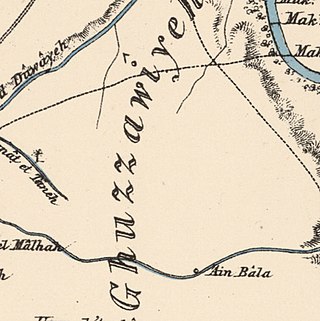
Al-Ghazzawiyya, was a Palestinian village located 2 kilometers east of the city of Bet Shean (Bisan). In 1945, the population was 1,640, 1,020 Arab and 620 Jewish.
Qumya, was a Palestinian village of 510 inhabitants when it was depopulated prior to the 1948 Arab-Israeli war.

Jabbul, is a depopulated former Palestinian Arab village located 7 km north of Baysan. During Operation Gideon, the village was occupied by the Golani Brigade.

Al-Bira, is a depopulated former Palestinian village located 7.5 km north of Baysan. During Operation Gideon, the village was occupied by the Golani Brigade.
Arab al-Bawati, was a Palestinian Arab village in the District of Baysan. It was depopulated during the 1948 Arab-Israeli War.

Arab al-Safa, was a Palestinian Arab village in the District of Baysan. It was depopulated during the 1948 Arab-Israeli War. It was located 7.5 km south of Baysan.
Al-Ashrafiyya, was a Palestinian Arab village in the District of Baysan. It was depopulated during the 1947–1948 Civil War in Mandatory Palestine. It was located 4.5 km southwest of Baysan.
Al-Hamra, was a Palestinian Arab village in the District of Baysan. It was located 7.5 kilometres south of Baysan. It was depopulated by the Israeli Army during the 1948 Arab-Israeli War. The village was named after the Bedouin tribe who settled in the village lands centuries ago. The population in 1945 was 730, expanding to 847 in 1948.

Al-Khunayzir, was a Palestinian Arab village in the District of Baysan. It was depopulated during the 1948 Arab-Israeli War on May 20, 1948.

Masil al-Jizl was a Palestinian Arab village in the District of Baysan. It was depopulated by the Israel Defense Forces during the Arab-Israeli War. It was attacked and depopulated on May 31, 1948, as part of Operation Gideon.
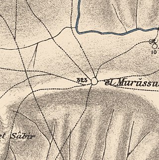
Al-Murassas, was a Palestinian Arab village in the District of Baysan. It was depopulated by the Israel Defense Forces during the 1948 War on May 16, 1948. The village was attacked as part of Operation Gideon.

Al-Sakhina, was a Palestinian Arab village in the District of Baysan. It was located five kilometres west of Baysan on the Jalud River on its way to the Jordan River. It was depopulated by the Israel Defense Forces during the 1947–1948 Civil War in Mandatory Palestine on May 12, 1948, as part of Operation Gideon.

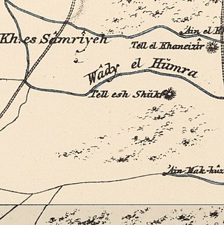
Al-Samiriyya, was a Palestinian Arab village in the District of Baysan. It was depopulated by the Israel Defense Forces during the 1948 Arab-Israeli War on May 27, 1948, as part of Operation Gideon. It was located 7 km southeast of Baysan.
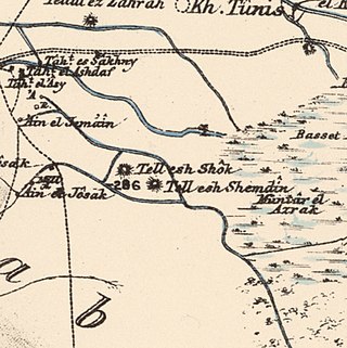
Tall al-Shawk, was a Palestinian village in the District of Baysan. It was depopulated by the Israel Defense Forces during the 1947–1948 Civil War in Mandatory Palestine on May 12, 1948, as part of Operation Gideon. It was located five km west of Baysan between the al-Januna'in River to the north and Wadi al-Jawsaq to the south. The village was built above an ancient archeological site and granite columns remain.
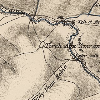
Al-Tira, was a Palestinian Arab village in the District of Baysan. It was depopulated by the Israel Defense Forces during the 1947–48 Civil War in Mandatory Palestine on 15 April 1948 as part of Operation Gideon under the command of Yosef Weitz. It was located 17.5 km north of Baysan overlooking Wadi al-Bira. However, 'Ayn al-Bayda' was the main source of drinking water for al-Tira inhabitants.

Umm 'Ajra, was a Palestinian Arab village in the District of Baysan. It was depopulated by the Israel Defense Forces during the 1948 Arab-Israeli War on May 31, 1948, as part of Operation Gideon. It was located 4 km south of Baysan and the 'Ayn Umm 'Ajra provided the village with water.

Zab'a, was a Palestinian Arab village in the District of Baysan. It was depopulated by the Israel Defense Forces during the 1947–1948 Civil War in Mandatory Palestine on May 12, 1948, as part of Operation Gideon. It was located 5.5 km northeast of Baysan on Wadi Yubla or Wadi al-'Ashsha.

Al-Rihaniyya was a Palestinian Arab village in the Haifa Subdistrict. It was depopulated during the 1947–1948 Civil War in Mandatory Palestine on 30 April 1948 as part of the battle of Mishmar HaEmek. It was located 25 km southeast of Haifa and 3 km northwest of Wadi al-Mileh.
Al-Jammasin al-Sharqi was a Palestinian Arab village in the Jaffa Subdistrict. It was depopulated during the 1948 Palestine War on March 17, 1948. It was located 9 km northeast of Jaffa.
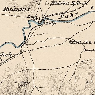
 1870s map
  1940s map
 modern map
  1940s with modern overlay map
