Amka עַמְקָה | |
---|---|
![]() | |
Coordinates: 32°58′46″N35°9′48″E / 32.97944°N 35.16333°E | |
Grid position | 215400/764900 ITM 166/265 PAL |
Country | ![]() |
District | Northern |
Council | Matte Asher |
Region | Western Galilee |
Founded | Bronze age (Beth ha-Emek) Classic era (Kfar Amka) 1949 (modern Moshav) |
Founded by | Yemenite Jews |
Population (2022) [1] | 833 |
Amka (Hebrew : עַמְקָה), also Amqa (Arabic : عمقا), is a moshav in the Matte Asher Regional Council of Israel's Northern District, near Acre. The moshav, located in the vicinity of Amqa, a Palestinian village depopulated during the 1948 Arab–Israeli War, was founded by Yemenite Jews in 1949. In 2022, its population was 833. [1]
Edward Henry Palmer thought that the name Amka derived from the Arabic word for “deep”, [2] but according to Ringgren, it preserves the name of Beth Ha-Emek, a city mentioned in Joshua 19:27 as part of the allotment of the Tribe of Asher. [3]
Amka is identified with Kefar Amiqo (Hebrew : כפר עמיקו), a place mentioned in the Mishnah and Tosefta. [4] Walid Khalidi writes that during the Roman period, the village located at the site was called Kefar Amqa. [5]
During the Crusader period, Amka was referred to as Amca. [5] In 1179, Joscelin III acquired the land of the village, [6] and in 1220 Jocelyn III's daughter Beatrix de Courtenay and her husband Otto von Botenlauben, Count of Henneberg, sold their land, including ‘’Amca’’, to the Teutonic Knights. [7]
In 1283, Amka was mentioned as part of the domain of the Crusaders during the hudna between the Crusaders based in Acre and the Mamluk sultan al-Mansur (Qalawun). [8]
Incorporated into the Ottoman Empire in 1517, Amqa appeared in the 1596 tax registers as being in the nahiya (subdistrict) of Akka under the liwa' (district) of Safad, with a population of 215. [9] All the inhabitants were Muslim. [10] The villagers paid taxes on a number of crops, such as wheat, barley, olives, cotton and fruit, and on other types of produce, such as goats and beehives. [9] [11]
In the early 18th century, the village was under control of Shaykh Najm. He had an agreement to sell the cotton from this and other villages under his control exclusively to the Dutch trader Paul Maashook. In return, Maashook would pay the miri (tax slated for funding the annual Hajj caravan), which was normally payable by the village shaykhs (chiefs). [12] The Syrian Sufi teacher and traveler Mustafa al-Bakri al-Siddiqi (1688–1748/9), who traveled through the region in the first half of the 18th century, said that he prayed in the village after visiting the citadel of Atlit. [5] In 1776 the village was used as a base by Ahmad Pasha al-Jazzar to suppress a revolt led by Ali al-Zahir, one of the sons of Sheikh Zahir al-Umar, who ruled the Galilee between 1730 and 1775. [13]
A map by Pierre Jacotin from Napoleon's invasion of 1799 showed the place, misnamed as El Mead, [14] In the late 19th century, the village was described as being built of stone, situated on a slight rise in a valley, surrounded by olive and fig trees, and arable land. There were an estimated 300 Druze living there. [15] Later, the residents were described as Muslims who maintained a village mosque. In 1887, the Ottoman authorities built a school in ´Amqa. [5]
A population list from about 1887 showed that Amka had about 740 inhabitants, all Muslim. [16]
Amqa عمقا 'Amqa | |
---|---|
Village | |
![]() | |
Geopolitical entity | Mandatory Palestine |
Subdistrict | Acre |
Date of depopulation | 10–11 July 1948 [17] |
Area | |
• Total | 6,060 dunams (6.06 km2 or 2.34 sq mi) |
Population (1945) | |
• Total | 1,240 [5] [18] |
Cause(s) of depopulation | Military assault by Yishuv forces |
Current Localities | Amka [19] |
In the 1922 census of Palestine conducted by the British Mandate authorities, Amqa had a population of 724 inhabitants, of whom 722 were Muslims and two Christians. [20] The population increased in the 1931 census to 895, all Muslims, living in a total of 212 houses. [21]
In 1945, the population of Amqa was 1,240 Muslims, [22] with over 6,000 dunums (1,500 acres ) of land according to an official land and population survey. [18] Of this, 1,648 dunams were plantations and irrigable land; 3,348 used for cereals, [23] while 36 dunams were built-up (urban) land. [24]
People from neighboring villages began to seek refuge in 'Amqa in May 1948. The village was attacked on 10-11 July by the Sheva' (Seventh) Brigade and the First Battalion of the Carmeli Brigade. [25] It was captured on 16 July 1948 during Operation Dekel and largely destroyed, with the exception of the school and mosque. Most of the inhabitants left with the exception of the Druze residents who still live nearby. Some inhabitants remained in Israel as present absentees. [26] On 1 March 1949 a UN observer reported a large group of villagers from 'Amqa seeking refuge in Salim. Another group arrived on 26 March. [27] In February 1950, the village was declared a closed area. [28] The Arab population remained under Martial Law until 1966.
In 1949, a group of Yemenite Jewish immigrants settled in Amka.[ citation needed ] [29] [30] The elementary school for boys founded in 1887 and the village mosque remained untouched although other structures were razed in the late 1950s. [5] [31] [32] According to Petersen, the mosque and school were used as warehouses. [5] [33]
Three khirbas (archaeological ruins) lay within Amka's vicinity and contain the foundations of buildings, well-chiseled building stones, presses, and a cistern. During archaeological searches of the area remnants of a Byzantine church were discovered but due to the destruction of the village no foundations could be established. [34] [35] [36] The Amka mosque was inspected by Petersen in 1991. The date of the mosque construction is not known, but it bears a general similarity to the nearby mosque of al-Ghabisiyya, and is probably of a similar age, i.e. early 19th century. [33]
Achziv or Az-Zeeb is an ancient site on the Mediterranean coast of northern Israel, between the border with Lebanon and the city of Acre. It is located 13.5 kilometres (8.4 mi) north of Acre on the coast of the Mediterranean Sea, within the municipal area of Nahariya. Today it is an Israeli national park.
Dayr al-Qassi or Deir el-Qasi, was a Palestinian Arab village located 26 km northeast of the city of Acre, which was depopulated during 1948 Arab-Israeli war.
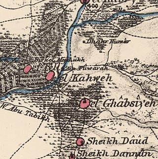
Al-Ghabisiyya was a Palestinian Arab village in northern Palestine, 16 km north-east of Acre in present-day Israel. It was depopulated by the Israel Defense Forces during the 1948 Palestinian expulsion and remains deserted.
Tarbikha, was a Palestinian Arab village. It was located 27 kilometres northeast of Acre in the British Mandate District of Acre that was captured and depopulated by the Israel Defense Forces during the 1948 Arab-Israeli war. The inhabitants of this village were, similar to the inhabitants of Southern Lebanon, Shia Muslims.
Umm al-Faraj, was a Palestinian village, depopulated in 1948.
Safsaf was a Palestinian village 9 kilometres northwest of Safed, present-day Israel. Its villagers fled to Lebanon after the Safsaf massacre in October 1948, during the 1948 Arab–Israeli War.
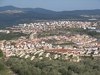
Ma'alot-Tarshiha is a city in the North District in Israel, about 20 kilometres east of Nahariya, and about 600 metres above sea level. The city was established in 1963 through a municipal merger of the Arab town of Tarshiha and the Jewish town of Ma'alot, creating a unique type of mixed city.
Ma'alul was a Palestinian village, with a mixed population of primarily Muslims with a substantial minority of Palestinian Christians, that was depopulated and destroyed by Israel during the 1948 Arab-Israeli war. Located six kilometers west of the city of Nazareth, many of its inhabitants became internally displaced refugees, after taking refuge in Nazareth and the neighbouring town of Yafa an-Naseriyye. Despite having never left the territory that came to form part of Israel, the majority of the villagers of Maalul, and other Palestinian villages like Andor and Al-Mujidal, were declared "absentees", allowing the confiscation of their land under the Absentees Property Law.
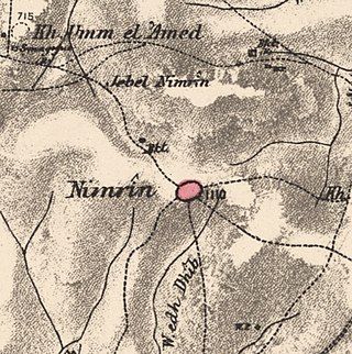
Nimrin was a Palestinian Arab town of 320 that was captured and depopulated by Israel during the 1948 Arab-Israeli War.
Qula was a Palestinian village in the Ramle Subdistrict of Mandatory Palestine, located 15 km northeast of Ramla. Its residents had their origins in Jimzu, Ammuriya and other places.
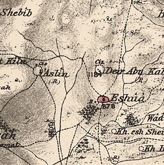
Islin was a Palestinian Arab village located 21 kilometers west of Jerusalem. The village had a population of 302 inhabitants and was depopulated during the 1948 Arab-Israeli war. It was occupied by Israeli forces, possibly from the Fourth Battalion of the Harel Brigade, on 18 July 1948 during Operation Dani, causing its inhabitants to leave. Eshtaol, a moshav, was built on the village's land.
Ein al-Zeitun, was a Palestinian Arab village, located 1.5 kilometres (0.93 mi) north of Safed in the Upper Galilee. During the early Ottoman period, Ein el-Zeitun had a mixed population of Muslims and Jews. Later, in the 19th century, it became entirely Muslim. The village's small population and land area as well as its proximity to Safad made it a suburb of the city. In 1945, the village had a population of 820 inhabitants and a total land area of 1,100 dunams. The village was depopulated in 1948, after the Ein al-Zeitun massacre.
Bayt Tima was a Palestinian Arab village in the Gaza Subdistrict, located 21 kilometers (13 mi) northeast of Gaza and some 12 kilometers (7.5 mi) from the coastline. It was situated in flat terrain on the southern coastal plain of Palestine. Bayt Tima was depopulated during the 1948 Arab-Israeli War. Its population in 1945 was 1,060.
Al-Ja'una or Ja'ouna, was a Palestinian village situated in Galilee near al-Houleh Plateau, overlooking the Jordan Valley. The village lay on a hillside 450–500 meters above sea level, 5 kilometers east of Safad near a major road connecting Safad with Tabariya. The village had its Arab residents expelled by Zionist forces in 1948 and was thereafter resettled by Jews, becoming a part of the Israeli settlement of Rosh Pinna.
Summil was a Palestinian Arab village in the Gaza Subdistrict, located 36 kilometers (22 mi) northeast of Gaza. It was situated on a sandy hill in the coastal plain and had a population of 950 in 1945. It was depopulated during the 1948 Arab-Israeli War.
Bayt Susin was a Palestinian Arab village in the Ramle Subdistrict of Mandatory Palestine, located 17 kilometers (11 mi) southeast of Ramla. In 1945, it had 210 inhabitants. The village was depopulated during the 1948 war by the Israeli 7th Brigade.
Biriyya was a Palestinian Arab village in the Safad Subdistrict. It was depopulated during the 1947–1948 Civil War in Mandatory Palestine on May 2, 1948, by The Palmach's First Battalion of Operation Yiftach. It was located 1.5 kilometres (0.9 mi) northeast of Safad. Today the Israeli moshav of Birya includes the village site.
Fara was a Palestinian Arab village in the Safad Subdistrict. It was depopulated during the 1948 Arab-Israeli War on October 30, 1948, under Operation Hiram. It was located 11.5 km north of Safad on the Wadi al-Fara.
Hadatha, also El Hadetheh or Hadateh, was a Palestinian Arab village in the District of Tiberias, located 12.5 km southwest of Tiberias. It was depopulated in the 1947–1948 civil war in Mandatory Palestine.
Ma'dhar was a Palestinian village in the Tiberias Subdistrict.