Al-Sawalima السوالمة | |
---|---|
Village | |
Etymology: es Sûâlimîyeh, the ruin of the Sâlem family [1] | |
Location within Mandatory Palestine | |
Coordinates: 32°06′59″N34°50′51″E / 32.11639°N 34.84750°E | |
Palestine grid | 134/170 |
Geopolitical entity | Mandatory Palestine |
Subdistrict | Jaffa |
Date of depopulation | March 30, 1948 [2] |
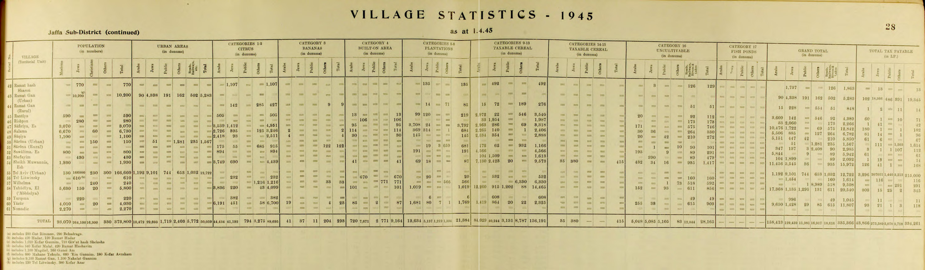
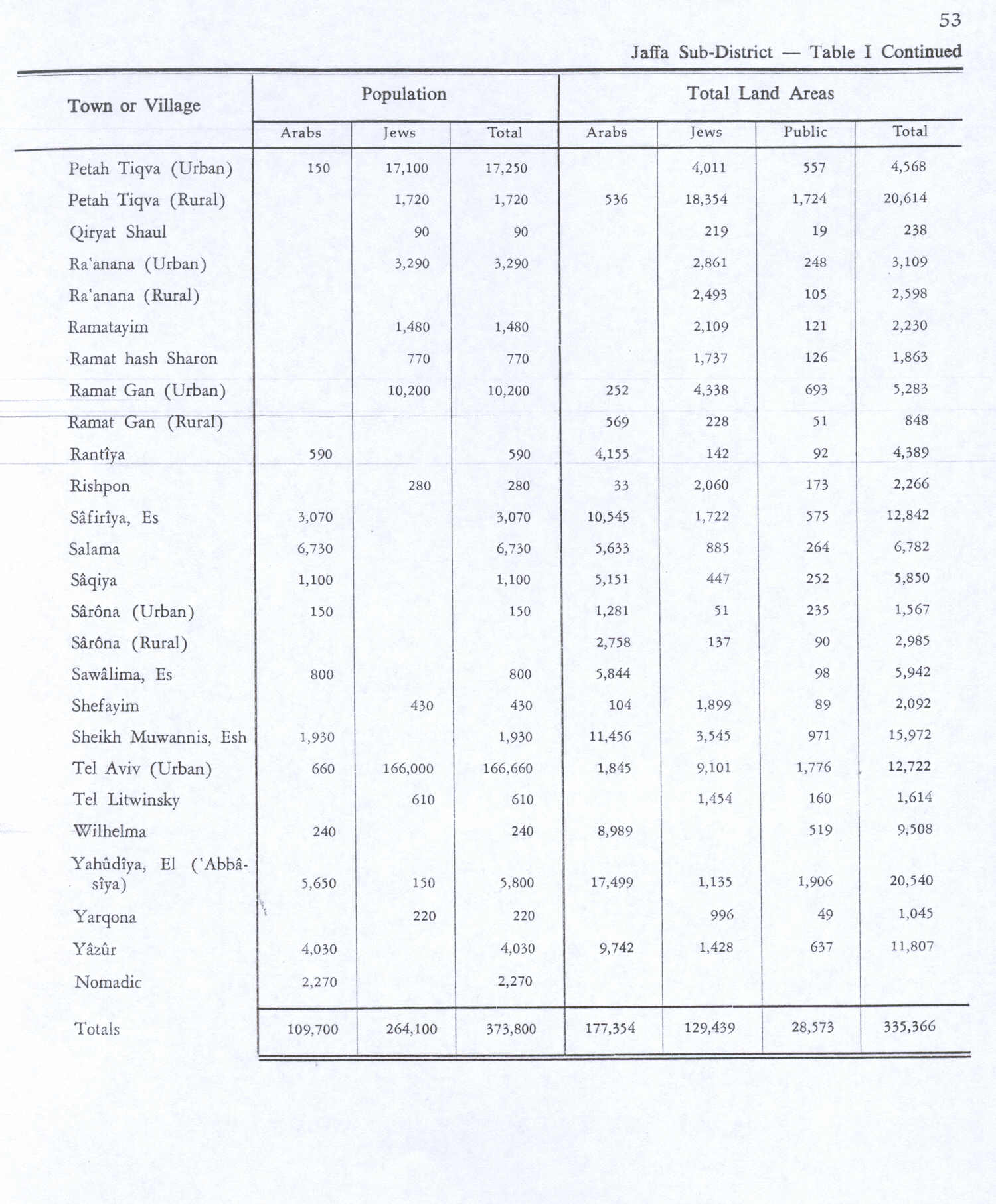
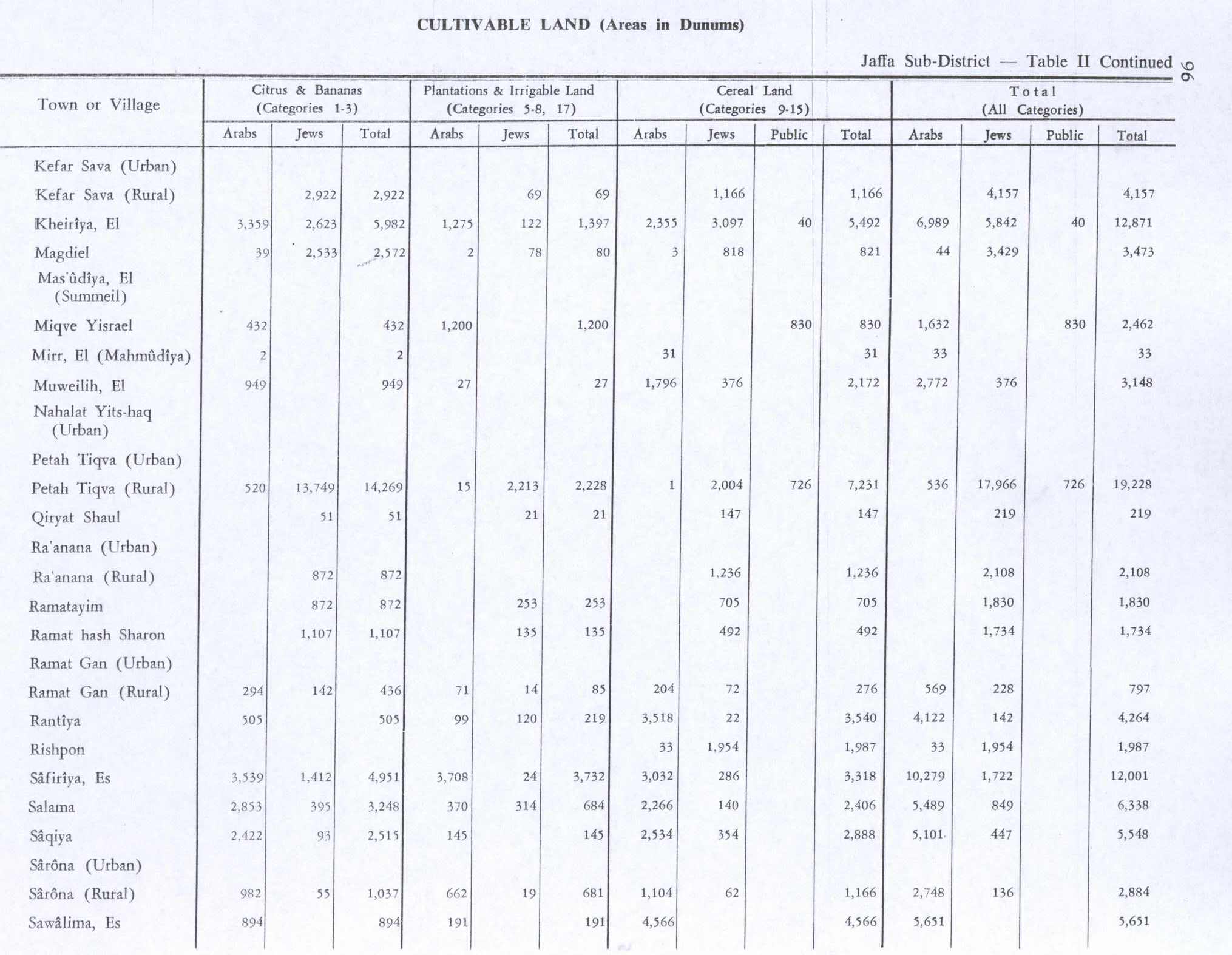
Population (1945) | |
• Total | 800 [3] [4] |
Cause(s) of depopulation | Fear of being caught up in the fighting |
Secondary cause | Influence of nearby town's fall |
Current Localities | Neve Sharett |
Al-Sawalima was a Palestinian Arab village in the Jaffa Subdistrict. It was depopulated during the 1947–1948 Civil War in Mandatory Palestine on March 30, 1948. It was located 11 km northeast of Jaffa, situated 2 km north of the al-'Awja River.
In 1051 AH/1641/2, the Bedouin tribe of al-Sawālima from around Jaffa attacked the villages of Subṭāra, Bayt Dajan, al-Sāfiriya, Jindās, Lydda and Yāzūr belonging to Waqf Haseki Sultan. [5]
In 1882 the PEF's Survey of Western Palestine noted at Khurbet es Sualimiyeh: “Traces of ruins only.“ [6]
In the 1922 census of Palestine conducted by the British Mandate authorities, Sawalmeh had a population of 70 Muslims, [7] increasing in the 1931 census when Es-Sawalmeh had 429 Muslim inhabitants. [8]
In the 1945 statistics, the village had a population of 800 Muslims, [3] while the total land area was 5,942 dunams, according to an official land and population survey. [4] Of the land area, a total of 894 were used for growing citrus and banana, 191 were for plantations and irrigable land, 4,566 for cereals, [9] while 291 dunams were classified as non-cultivable areas. [10]
Al-Sawalima had an elementary school for boys founded in 1946, with 31 students. [11]
Benny Morris gives "Fear of being caught up in the fighting" and "Influence of nearby town's fall" as reasons for why the village became depopulated on March 30, 1948. [2]
In 1992 the village site was described: "Cactuses grow on the village site. No identifiable traces of the former dwellings (tents or adobe houses) remain. Only the remnants of the one-room school are discernable. A highway runs past the north side of the site." [12]
Khirbat Zalafa was a small Palestinian Arab village in the Tulkarm Subdistrict, located about 15 kilometers (9.3 mi) northwest of Tulkarm. It was depopulated during the 1948 Palestine war. It was occupied by Yishuv forces on April 15, 1948 as a part of operation "Coastal Clearing."
Bayt Nabala or Beit Nabala was a Palestinian Arab village in the Ramle Subdistrict in Palestine that was destroyed during the 1948 Arab–Israeli War. The village was in the territory allotted to the Arab state under the 1947 UN Partition Plan, which was rejected by Arab leaders and never implemented. Its population in 1945, before the war, was 2,310.
Al-Khayriyya, also Ibn Ibraq, was a Palestinian Arab village located 7.5 kilometers east of Jaffa. It became depopulated in April 1948 as a result of a military assault by the Alexandroni Brigade of the pre-state Israeli forces during the 1948 Palestine war. The village lands would later be used by Israel as the Hiriya landfill.
Fajja was a Palestinian town located 15 kilometers northeast of Jaffa. Ethnically cleansed during the Nakba, its land area is today part of the Israeli city of Petah Tikva.
Rantiya was a Palestinian village, located 16 kilometers east of Jaffa. During the British Mandate in Palestine, in 1945 it had a population of 590 inhabitants.
Arab al-Bawati, was a Palestinian Arab village in the District of Baysan. It was depopulated during the 1948 Arab-Israeli War.
Tall al-Shawk, was a Palestinian village in the District of Baysan. It was depopulated by the Israel Defense Forces during the 1947–1948 Civil War in Mandatory Palestine on May 12, 1948, as part of Operation Gideon. It was located five km west of Baysan between the al-Januna'in River to the north and Wadi al-Jawsaq to the south. The village was built above an ancient archeological site and granite columns remain.
Al-Rihaniyya was a Palestinian Arab village in the Haifa Subdistrict. It was depopulated during the 1947–1948 Civil War in Mandatory Palestine on 30 April 1948 as part of the battle of Mishmar HaEmek. It was located 25 km southeast of Haifa and 3 km northwest of Wadi al-Mileh.
Mughallis was a Palestinian Arab village located 30.5 kilometers (19.0 mi) northwest of Hebron. It was depopulated during the 1948 Arab-Israeli War between July 9–10, 1948 as part of Operation An-Far.
Ijlil al-Shamaliyya was a Palestinian Arab village in the Jaffa Subdistrict. Established in the 19th century, it was founded by Bani Sa'b tribesmen from the Qalqiliya area and migrants from Egypt. It was depopulated during the 1947–1948 Civil War in Mandatory Palestine on April 3, 1948.
Al-Safiriyya was a Palestinian Arab village in the Jaffa Subdistrict. It was depopulated during Operation Hametz in the 1948 Palestine War on May 20, 1948. It was located 11 km east of Jaffa, 1.5 km west of Ben Gurion Airport.
Al-Barriyya was a Palestinian village in the Ramle Subdistrict of Mandatory Palestine. It was depopulated during the 1948 Arab–Israeli War on July 10, 1948, as part of Operation Dani. It was located 5.5 km southeast of Ramla, on the eastern bank of Wadi al-Barriyya.
Bayt Shanna was a Palestinian Arab village in the Ramle Subdistrict of Mandatory Palestine. It was depopulated during the 1948 Arab–Israeli War on July 15, 1948, during the second stage of Operation Dani. It was located 11.5 km southeast of Ramla.
Bir Ma'in was a Palestinian Arab village in the Ramle Subdistrict. It was depopulated during the 1948 Arab-Israeli War on July 15, 1948 during the second phase of Operation Danny by the First and Second Battalions of the Yiftach Brigade. It was located 14 km east of Ramla. The village was defended by the Jordanian Army.
Daniyal was a Palestinian village in the Ramle Subdistrict that was located 5 km east of Ramla and southeast of Lydda. It was depopulated during the 1948 Arab–Israeli War on July 10, 1948, by the Yiftach Brigade under the first phase of Operation Dani, as part of the broader 1948 Palestinian expulsion and flight and Nakba.
Dayr Tarif was a Palestinian Arab village in the Ramle Subdistrict of Mandatory Palestine. It was depopulated during the 1948 Arab-Israeli War on July 10, 1948.
Khirbat al-Duhayriyya was a Palestinian Arab village in the Ramle Subdistrict. It was depopulated during the 1948 Arab-Israeli War on July 10, 1948, by the Givati Brigade under the first phase of Operation Dani. It was located 6 km northeast of Ramla.
Al-Haditha was a Palestinian village in the Ramle Subdistrict. It was located 8 km northeast of Ramla, on the bank of Wadi al-Natuf. The site, now known as Tel Hadid, has yielded significant archaeological remains from many periods. Al-Haditha was depopulated during the 1948 Arab-Israeli War on July 12, 1948, under the first stage of Operation Dani.
Al-Khayma was a Palestinian Arab village in the Ramle Subdistrict of Mandatory Palestine. It was depopulated during the 1948 Arab–Israeli War on July 9, 1948, by the Givati Brigade of Operation An-Far. It was located 18.5 km south of Ramla.
Al-Kunayyisa was a small Palestinian Arab village in the Ramle Subdistrict. It was depopulated during the 1948 Arab–Israeli War on July 10, 1948, under the first stage of Operation Dani. It was located 12 km southeast of Ramla.