
Al-'Abisiyya was a Palestinian Arab village in the District of Safad. It was depopulated during the 1948 Arab-Israeli War on May 29, 1948, by The Palmach's First Battalion of Operation Yiftach. It was located 28.5 km northeast of Safad near to the Banyas River which the village relied on for irrigation.

Arab al-Shamalina also known as Khirbat Abu Zayna was a Palestinian Arab village in the Safad Subdistrict. It was depopulated during the 1947–1948 Civil War in Mandatory Palestine on May 4, 1948, under Operation Matate (Broom), a sub operation of Operation Yiftach. It was located 13 km southeast of Safad near the Jordan River.
Arab al-Zubayd was a Palestinian village in the Safad Subdistrict. It was depopulated during the 1947–1948 Civil War in Mandatory Palestine on April 20, 1948, when the villagers fled on hearing the intentions of The Palmach's First Battalion of Operation Yiftach. It was located 15 km northeast of Safad, near the al-Mutilla-Safad—Tiberias highway.
Baysamun or Beisamoun was a small Palestinian Arab village, located 16.5 kilometers (10.3 mi) in the marshy Hula Valley northeast of Safad. In 1945, it had a population of 20. It was depopulated during the 1948 War on May 25, 1948, by the Palmach's First Battalion in Operation Yiftach.

Al-Butayha was a Palestinian Arab village in the Safad Subdistrict. It was depopulated during the 1947–1948 Civil War in Mandatory Palestine on May 4, 1948, by the Palmach's First Battalion during Operation Matateh. It was located 13 km southeast of Safad, quarter of a mile east of the Jordan River, a little northeast of the northern tip of the Sea of Galilee. Many of the inhabitants were forced into Syria.

Al-Buwayziyya was a Palestinian Arab village in the Safad Subdistrict. It was depopulated during the 1947–1948 Civil War in Mandatory Palestine on May 11, 1948, by the Palmach's First Battalion of Operation Yiftach. It was located 22 km northeast of Safad.
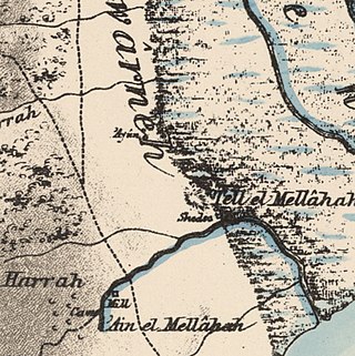
Al-Dawwara was a Palestinian Arab village in the Safad Subdistrict. It was depopulated during the 1948 War on May 25, 1948, by the Palmach's First Battalion of Operation Yiftach. It was located 27 km northeast of Safad, bordering three rivers that flowed into lake al-Hula: the al-Hasbani, Banyas, and Dan rivers.
Al-Dirdara, also known as Mazari ed Daraja, was a Palestinian Arab village in the Safad Subdistrict. It was depopulated during the 1947–1948 Civil War in Mandatory Palestine on May 1, 1948, under Operation Yiftach. It was located 13 km east of Safad.

Ghuraba was a Palestinian Arab village in the Safad Subdistrict. It was depopulated during the 1948 War on May 28, 1948, by the Palmach's First Battalion of Operation Yiftach. It was located 22 km northeast of Safad.

Al-Shawka al-Tahta was a Palestinian Arab village in the Safad Subdistrict. It was depopulated during the 1947–1948 Civil War in Mandatory Palestine on May 14, 1948, by the Palmach's First Battalion of Operation Yiftach. It was located 31.5 km northeast of Safad.

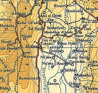
Al-Na'ima was a Palestinian Arab village in the Safad Subdistrict of Mandatory Palestine located 26 kilometres (16 mi) northeast of Safad, near the al-Hula Plain. The settlement was depopulated during the 1947-1948 civil war on May 14, 1948 by the Israeli Palmach's First Battalion as part of Operation Yiftach.

Al-Zuq al-Tahtani was a Palestinian Arab village in the Safad Subdistrict. It was depopulated during the 1947–1948 Civil War in Mandatory Palestine on May 11, 1948, by the Palmach's First Battalion of Operation Yiftach. It was located 30 km northeast of Safad.
Khiyam al-Walid was a Palestinian Arab village in the Safad Subdistrict located 25.5 kilometers (15.8 mi) northeast of Safad along the Syrian border. It was on situated on a hill 150 meters (490 ft) above sea level on the eastern edge of the Hula Valley. In 1945, there were 280 predominantly Muslim inhabitants. It was depopulated during the 1948 Palestine War.

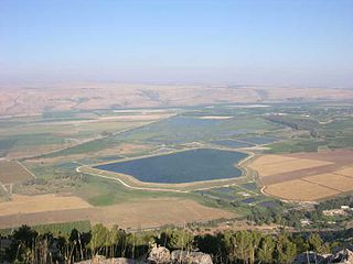
Al-Mansura was a Palestinian Arab village in the Safad Subdistrict. It was located 31 kilometres (19 mi) northeast of Safad on the Banyas River, to the south of what is now Dafna.

Khirbat al-Muntar was a Palestinian Arab village in the Safad Subdistrict. It was depopulated during the 1948 Arab-Israeli War by Palmach's First Battalion and 'Oded Brigade of Operation Yiftach after resistance by the Syrian Army. It was located 8.5 km east of Safad.
Al-Zawiya was a Palestinian Arab village in the Safad Subdistrict. It was depopulated during the 1947–1948 Civil War in Mandatory Palestine on May 24, 1948, by the Palmach's First Battalion of Operation Yiftach. It was located 23 km northeast of Safad.
Al-Salihiyya was a Palestinian Arab village populated by people traditionally associated with the Ghawarna, a generic exonym denoting inhabitants of the drainage plains of the Hula Valley. It was depopulated during the 1948 War on May 25, 1948, by the Israeli Palmach. It was located in the Safad Subdistrict, 25 km northeast of Safad, at the intersection of the Jordan River and Wadi Tur'an.

Al-Sanbariyya was a Palestinian village in the Safad Subdistrict. It was depopulated during the 1947–1948 Civil War in Mandatory Palestine on May 1, 1948, by Palmach's First Battalion under Operation Yiftach. It was located 31.5 km northeast of Safad, near Wadi Hasibani.

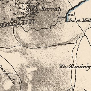
Al-'Ulmaniyya was a Palestinian Arab village in the Safad Subdistrict. It was depopulated during the 1947–1948 Civil War in Mandatory Palestine on April 20, 1948, by the Palmach's First Battalion of Operation Yiftach. It was located 14.5 km northeast of Safad.

Al-Wayziyya was a Palestinian village in the Safad Subdistrict, located south east of Yarda. It was depopulated during the 1947–48 Civil War in Mandatory Palestine on May 1, 1948, by the Palmach's First Battalion of Operation Yiftach. It was located 8.5 km northeast of Safad.
 1940s map
  modern map
 1940s with modern overlay map
