Al-Sarafand

Last updated

Contents

al-Sarafand
الصرفند
Sarepta Yudee
Etymology: from a personal name [1]
Historical map series for the area of al-Sarafand (1870s).jpg 1870s map
Historical map series for the area of al-Sarafand (1940s).jpg 1940s map
Historical map series for the area of al-Sarafand (modern).jpg modern map
Historical map series for the area of al-Sarafand (1940s with modern overlay).jpg 1940s with modern overlay map
A series of historical maps of the area around Al-Sarafand (click the buttons)
Mandatory Palestine location map.svg
Red pog.svg
al-Sarafand
Location within Mandatory Palestine
Coordinates: 32°38′48″N34°56′08″E / 32.64667°N 34.93556°E / 32.64667; 34.93556
Palestine grid 144/228
Geopolitical entity Mandatory Palestine
Subdistrict Haifa
Date of depopulation16 July 1948 [2]
Area
[3]
  Total
5,409  dunams (5.409 km2 or 2.088 sq mi)
Population
 (1945)
  Total
290 [4] [3]
Cause(s) of depopulationMilitary assault by Yishuv forces
Secondary causeInfluence of nearby town's fall
Current Localities Tzrufa [5]

Al-Sarafand (Arabic : الصرفند) was a Palestinian Arab village near the Mediterranean shore south of Haifa. In Ottoman tax records, it is shown that the village had a population of 61 inhabitants in 1596. According to a land and population survey by Sami Hadawi, al-Sarafand's population was 290 in 1945, entirely Arab. [3]

Etymology

Sarafand or Sarafend (Ṣarafand / صرفند) is an Arabic rendition of the Phoenician place-name *Ṣrpt. [6] Al-Sarafand was known to the Crusaders as Sarepta Yudee. [7]

History

Pottery remains from the late Roman era and Byzantine era have been found here. [8]

Ayyubid forces captured al-Sarafand from the Crusaders in 1187-1188. [9] The village appears in the waqf of the tomb (turba) and madrasa of amir Qurqamaz in Egypt. [10]

Ottoman era

In 1517 the village of 'Sarafanda' was incorporated into the Ottoman Empire with the rest of Palestine. During the 16th and 17th centuries, it belonged to the Turabay Emirate (1517-1683), which encompassed also the Jezreel Valley, Haifa, Jenin, Beit She'an Valley, northern Jabal Nablus, Bilad al-Ruha/Ramot Menashe, and the northern part of the Sharon plain. [11] [12]

From Ottoman records it is known that in 1596 Sarafand was a village in the nahiya ("subdistrict") of Shafa, ( liwa' ("district") of Lajjun), with a population of 11 Muslim households, an estimated 61 persons. Villagers paid a fixed tax-rate of 25% to the authorities for the crops that they cultivated, which included wheat, barley, summer crops such as corn, beans, melons, and vegetables, and raising goats; a total of 8,500 akçe. [7] [13]

In 1799, it appeared as the village Sarfend on the map that Pierre Jacotin compiled that year. [14] In 1859 the village of Sarafand was described as being situated on a ridge between a plain and the beach. Consul Rogers estimated that 150 people lived in it and cultivated 16 faddans. [15] [16] Four years later, Victor Guérin stated that the population size was not exceeding 300. [17]

According to the PEF's Survey of Western Palestine , who visited in 1873; "North of this village there is a system of rock- cut tombs, sixteen in all. Eight have each three loculi under arcosolia, and in three cases the rolling stones which closed the doors lie beside them. One of these stones was 3 feet diameter, and 1 foot thick, weighing probably about 6 cwt. Five of the tombs are single loculi, open in front, cut in the face of the cliff under arcosolia; two of the tombs have only two loculi each, and one is blocked up. This group presents the best examples found by the Survey party of the rolling stone arrangement for a tomb door." [18]

A population list from about 1887 showed that Sarafand had about 270 inhabitants; all Muslims. [19]

British Mandate era

In the 1922 census of Palestine, conducted by the British Mandate authorities, Sarafand had a population of 204; all Muslims, [20] decreasing in the 1931 census to 188; still all Muslim, in a total of 38 houses. [21]

The village economy depended on agriculture, animal husbandry and salt making. [22]

In the 1945 statistics, the village had a population of 290 Muslims, [4] and the village's lands spanned 5,409 dunams. [3] The population was entirely Muslim. [23] A total of 3,244 dunums of land was allocated to cereals; 22 dunums were irrigated or used for orchards, [24] while 6 dunams were built-up (urban) land. [25]

Al-Sarafand (Sarafand) 1938 1:20,000 Jaba 1938.jpg
Al-Sarafand (Sarafand) 1938 1:20,000
Al-Sarafand (Sarafand) 1945 1:250,000 Jaba 1945.jpg
Al-Sarafand (Sarafand) 1945 1:250,000

1948, and aftermath

During the 1947–1948 civil war in Mandatory Palestine, the inhabitants were ethnically cleansed in several stages. Most fled in early May towards al-Tira and when al-Tira was depopulated they left for Jenin. Some returned and remained in al-Sarafand until Israeli forces — composed of the Carmeli and Alexandroni Brigades — assaulted the village on July 16, 1948. At the time, Arab Liberation Army volunteers and local militia were defending al-Sarafand. [26] Most of the inhabitants fled to the southeast line of Wadi Ara, where the Iraqi Army was stationed. Later, they crossed the Jordan River, and since then the majority of al-Sarafand’s refugees have been living in Jordan. Only one former resident of al-Sarafand remained in Israel. The village houses were not immediately demolished by the Israelis and remained empty for many years. When they were eventually destroyed, the mosque was the only building spared. [7]

Petersen inspected the village mosque and adjacent vaults in 1994, and described the mosque as "a tall rectangular box-like building standing on a terrace near the top of the ridge on which it was built. The mosque is entered through a doorway in the middle of the north wall. The interior is divided into two long cross-vaulted bays resting on six large piers. There are four windows in west wall facing the sea. The mihrab is placed in the centre of the south wall and can be seen on the exterior as a rectangular projection. To the west of the mihrab are the remains of a minbar (now destroyed). The lower sections of the wall are approximately 1 m. thick, whilst the upper part of the south and north walls are considerably thinner (0.3 m.). Although the present building does not appear to be very old (late nineteenth or early twentieth centuries) it does appear to in incorporate an earlier structure which is visible in the exterior walls. To the south of the mosque is a rectangular area of ruins (approximately 30m x 40m) containing several barrel-vaulted chambers. Three of these are still accessible; one on the north side nearest the mosque, and two on the south side next to the quarry cliff. Each vault is about 7m long; one is 2.52m wide and the other is 3.52m wide. More intensive investigation could reveal a basic plan of this structure." [27]

Mosque restoration

In 1999, the 'Aqsa Society for the Preservation of Islamic Holy Sites decided to restore al-Sarafand’s mosque. In May 2000, while restoration was on the verge of completion, the mosque was destroyed overnight by a bulldozer. The perpetrator was never identified. The activists covered the ruins by a large tent and maintained a vigil at the site. Removal of the tent was negotiated with the Israeli authorities. It was agreed that the site would be fenced to protect it, but that did not happen and the activists built a more permanent structure. The latter was demolished by the police in March 2002, but the ruined mosque continues to be used for Friday prayers. [7] According to the Or Commission report, Israeli authorities did not grant a license for rebuilding the mosque after the demolition; a decision that contributed to the souring of relations between local Muslim residents and the authorities. The Or Commission report also claims that activities by Islamic organizations such as the aforementioned society may be using religious pretenses to further political aims. The commission describes such actions as a factor in 'inflaming' the Muslim population in Israel against the authorities, and cites the Sarafand mosque episode, with Muslims' attempts to restore the mosque and Jewish attempts to stop them, as an example of the 'shifting of dynamics' of the relationship between Muslims and the Israeli authorities.

Ilan Pappe

The Israeli new historian Ilan Pappe has a different story of the events. He writes:"The mosque was a hundred years old when the Israeli government gave the go-ahead to have it bull-dozed on 25 july 2000 ignoring a petition addressed to the then prime minister Ehud Barak, beseeching him not to authorise this official act of vandalism." [28]

See also

Related Research Articles

<span class="mw-page-title-main">Danna, Baysan</span> Place in Baysan, Mandatory Palestine

Danna, was a Palestinian village 13 kilometres north of Baysan that was captured by the Israel Defense Forces during the 1948 Arab-Israeli war, and the villagers were expelled.

<span class="mw-page-title-main">Kawfakha</span> Place in Gaza, Mandatory Palestine

Kawfakha' was a Palestinian village located 18 kilometers (11 mi) east of Gaza that was depopulated during the 1948 Arab-Israeli war.

<span class="mw-page-title-main">Hamama</span> Place in Gaza, Mandatory Palestine

Hamama was a Palestinian town of over 5,000 inhabitants that was depopulated during the 1948 Arab-Israeli War. It was located 24 kilometers north of Gaza. It was continuously inhabited from the Mamluk period until 1948.

<span class="mw-page-title-main">Qula</span> Place in Ramle, Mandatory Palestine

Qula was a Palestinian village in the Ramle Subdistrict of Mandatory Palestine, located 15 km northeast of Ramla. Its residents had their origins in Jimzu, Ammuriya and other places.

<span class="mw-page-title-main">Bayt Jirja</span> Place in Gaza, Mandatory Palestine

Bayt Jirja or Beit Jerja was a Palestinian Arab village 15.5 km Northeast of Gaza. In 1931 the village consisted of 115 houses. It was overrun by Israeli forces during operation Yo'av in the 1948 Arab-Israeli war. Bayt Jirja was found depopulated in November 1948, during "clean up sweeps" to expel any partial inhabited villages and destroy village housing to prevent any possible re-occupation in the area. The village was completely destroyed after the occupation and only one tomb remains.

<span class="mw-page-title-main">Al-Tira, Haifa</span> Place in Haifa, Mandatory Palestine

al-Tira was a Palestinian town located 7 kilometres south of Haifa. It was made up of five khirbets, including Khirbat al-Dayr where lie the ruins of St. Brocardus monastery and a cave complex with vaulted tunnels.

<span class="mw-page-title-main">Miska, Tulkarm</span> Village in Tulkarm, Mandatory Palestine

Miska was a Palestinian village, located fifteen kilometers southwest of Tulkarm, depopulated in 1948.

<span class="mw-page-title-main">Tabsur</span> Village in Tulkarm, Mandatory Palestine

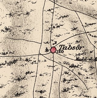
Tabsur, also Khirbat 'Azzun, was a Palestinian village located 19 kilometres southwest of Tulkarm. In 1931, the village had 218 houses and an elementary school for boys. Its Palestinian population was expelled during the 1948 Arab-Israeli war.

<span class="mw-page-title-main">Kafr Lam</span> Place in Haifa, Mandatory Palestine

Kafr Lam was a Palestinian Arab village located 26 kilometres (16 mi) south of Haifa on the Mediterranean coast. The name of the village was shared with that of an Islamic fort constructed there early in the period of Arab Caliphate rule in Palestine. To the Crusaders, both the fort and the village, which they controlled for some time in the 13th century, were known as Cafarlet.

<span class="mw-page-title-main">Bayt Jiz</span> Place in Ramle, Mandatory Palestine

Bayt Jiz was a Palestinian Arab village situated on undulating land in the western foothills of the Jerusalem heights, 15 kilometers (9.3 mi) southwest of Ramla. In 1945, it had a population of 550. It was occupied by Israeli forces in the 1948 Arab–Israeli War and became depopulated.

<span class="mw-page-title-main">Bayt Tima</span> Place in Gaza, Mandatory Palestine

Bayt Tima was a Palestinian Arab village in the Gaza Subdistrict, located 21 kilometers (13 mi) northeast of Gaza and some 12 kilometers (7.5 mi) from the coastline. It was situated in flat terrain on the southern coastal plain of Palestine. Bayt Tima was depopulated during the 1948 Arab-Israeli War. Its population in 1945 was 1,060.

<span class="mw-page-title-main">Kafr Saba</span> Place in Tulkarm, Mandatory Palestine

Kafr Saba was a Palestinian village famous for its shrine dating to the Mamluk period and for a history stretching back for two millennia. In Roman times, it was called Capharsaba and was an important town in Palestine. By around 1000, it was noted as a village with a mosque. The people of Kafr Saba were said to have come from Hebron because of crop failures.

<span class="mw-page-title-main">Sarafand al-Amar</span> Place in Ramle, Mandatory Palestine

Sarafand al-Ammar was a Palestinian Arab village situated on the coastal plain of Palestine, about 5 kilometers (3.1 mi) northwest of Ramla. It had a population of 1,950 in 1945 and a land area of 13,267 dunams.

<span class="mw-page-title-main">Sirin, Baysan</span> Place in Baysan, Mandatory Palestine

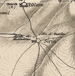
Sirin, was a Palestinian Arab village located 17 kilometers (11 mi) north of Beisan. The village was depopulated and destroyed in 1948. Only the village cemetery and one house remain standing, along with the remains of a mosaic pavement and a vaulted spring dating to the Byzantine period. Mentioned in historical documents, the 1596 census indicated it had 45 households; by 1945, the number of inhabitants had risen to 810.

<span class="mw-page-title-main">Ni'ilya</span> Place in Gaza, Mandatory Palestine

Ni'ilya was a Palestinian village in the Gaza Subdistrict. It was depopulated during the 1948 Arab–Israeli War on November 4, 1948, under Operation Yo'av. It was located 19 km northeast of Gaza in the city territory of modern Ashkelon. The village was defended by the Egyptian Army.

<span class="mw-page-title-main">Al-Haram, Jaffa</span> Village in Jaffa, Mandatory Palestine

Al-Haram, was a Palestinian Arab village in the Jaffa Subdistrict, in Mandatory Palestine. It was located 16 km north of Jaffa, adjacent to the ruins of the medieval walled city of Arsuf, and its extent was estimated to range between 9,653 and 11,698 dunams of which 5,150 were accounted for in the cadastral registrations. It was depopulated during the 1948 war.

<span class="mw-page-title-main">Al-Safiriyya</span> Place in Jaffa, Mandatory Palestine

Al-Safiriyya was a Palestinian Arab village in the Jaffa Subdistrict. It was depopulated during Operation Hametz in the 1948 Palestine War on May 20, 1948. It was located 11 km east of Jaffa, 1.5 km west of Ben Gurion Airport.

<span class="mw-page-title-main">Bir Ma'in</span> Place in Ramle, Mandatory Palestine

Bir Ma'in was a Palestinian Arab village in the Ramle Subdistrict. It was depopulated during the 1948 Arab-Israeli War on July 15, 1948 during the second phase of Operation Danny by the First and Second Battalions of the Yiftach Brigade. It was located 14 km east of Ramla. The village was defended by the Jordanian Army.

<span class="mw-page-title-main">Dayr Tarif</span> Place in Ramle, Mandatory Palestine

Dayr Tarif was a Palestinian Arab village in the Ramle Subdistrict of Mandatory Palestine. It was depopulated during the 1948 Arab-Israeli War on July 10, 1948.

<span class="mw-page-title-main">Sarafand al-Kharab</span> Place in Ramle, Mandatory Palestine

Sarafand al-Kharab was a Palestinian Arab village in the Ramle Subdistrict, located 50 meters (160 ft) above sea level, 7 kilometers (4.3 mi) west of Ramla, in the area that is today northeast of Ness Ziona.

References

  1. Palmer, 1881, p. 141
  2. Morris, 2004, p. xviii, village #174. Also gives causes of depopulation
  3. 1 2 3 4 Government of Palestine, Department of Statistics. Village Statistics, April, 1945. Quoted in Hadawi, 1970, p. 49
  4. 1 2 Government of Palestine, Department of Statistics, 1945, p. 14
  5. Morris, 2004, p. xxii, settlement #124, 1949
  6. Marom, Roy; Zadok, Ran (2023). "Early-Ottoman Palestinian Toponymy: A Linguistic Analysis of the (Micro-)Toponyms in Haseki Sultan's Endowment Deed (1552)". Zeitschrift des Deutschen Palästina-Vereins. 139 (2).
  7. 1 2 3 4 Efrat Ben-Ze'ev and Issam Aburaiya (2004). ""Middle-ground" politics and the re-Palestinization of places in Israel". International Journal of Middle East Studies. 36 (4): 639–655. doi:10.1017/S0020743804364068. S2CID   155913777.
  8. Oren, 2004, Es-Sarafand
  9. Abu Shama RHC (or.), IV, p. 303. Cited in Petersen, 2001, p. 272
  10. MPF, 11 No. 31. Cited in Petersen, 2001, p. 272
  11. al-Bakhīt, Muḥammad ʻAdnān; al-Ḥamūd, Nūfān Rajā (1989). "Daftar mufaṣṣal nāḥiyat Marj Banī ʻĀmir wa-tawābiʻihā wa-lawāḥiqihā allatī kānat fī taṣarruf al-Amīr Ṭarah Bāy sanat 945 ah". www.worldcat.org. Amman: Jordanian University. pp. 1–35. Retrieved 2023-05-15.
  12. Marom, Roy; Marom, Tepper; Adams, Matthew, J (2023). "Lajjun: Forgotten Provincial Capital in Ottoman Palestine". Levant. 55 (2): 218–241. doi:10.1080/00758914.2023.2202484. S2CID   258602184.{{cite journal}}: CS1 maint: multiple names: authors list (link)
  13. Hütteroth and Abdulfattah, 1977, p. 158. Quoted in Khalidi, 1992, p.188
  14. Karmon, 1960, p. 163 Archived 2017-12-01 at the Wayback Machine
  15. Conder and Kitchener, 1882, SWP II, p. 4. Quoted in Khalidi, 1992, p. 188
  16. Cited in Petersen, 2001, pp. 272-3.
  17. Guérin, 1875, pp. 301-302; cited in Conder and Kitchener, 1882, SWP II, p. 4
  18. Conder and Kitchener, 1882, SWP II, p. 33
  19. Schumacher, 1888, p. 178
  20. Barron, 1923, Table XI, Sub-district of Haifa, p. 34
  21. Mills, 1932, p. 95
  22. Khalidi, 1992, p. 188
  23. Village Statistics April 1945, The Palestine Government, p. 12 Archived 2012-06-09 at the Wayback Machine
  24. Government of Palestine, Department of Statistics. Village Statistics, April, 1945. Quoted in Hadawi, 1970, p. 92
  25. Government of Palestine, Department of Statistics. Village Statistics, April, 1945. Quoted in Hadawi, 1970, p. 142
  26. Morris, 2004, p. ?
  27. Petersen, 2001, pp. 272-273
  28. The Ethnic Cleansing of Palestine, Ilan Pappe, Oneworld, Oxford, 2006, p.217

Bibliography