Bayt Jirja or Beit Jerja was a Palestinian Arab village 15.5 km Northeast of Gaza. In 1931 the village consisted of 115 houses. It was overrun by Israeli forces during operation Yo'av in the 1948 Arab-Israeli war. Bayt Jirja was found depopulated in November 1948, during "clean up sweeps" to expel any partial inhabited villages and destroy village housing to prevent any possible re-occupation in the area. The village was completely destroyed after the occupation and only one tomb remains.

Barbara was a Palestinian Arab village in the Gaza Subdistrict located 17 km northeast of Gaza city, in the vicinity of modern Ashkelon. It had an entirely Arab population of 2,410 in 1945. The village consisted of nearly 14,000 dunums of which approximately 12,700 dunums was able to be cultivated. It was captured by Israel during the 1948 Arab–Israeli War.

Qastina was a Palestinian village, located 38 kilometers northeast of Gaza City. It was ethnically cleansed during the 1948 Arab-Israeli war.

Simsim, also spelled Semsem or Sumsum, was a Palestinian village, located 15 kilometers (9.3 mi) northeast of Gaza. It was depopulated and destroyed during the 1948 Palestine war as part of the 1948 Palestinian expulsion and the Nakba.

Najd was a Palestinian Arab village, located 14 kilometers (8.7 mi) northeast of Gaza City. During the British Mandate in Palestine, children from Najd attended school in the nearby village of Simsim. On 13 May 1948, Najd was occupied by the Negev Brigade as part of Operation Barak, and the villagers were expelled.
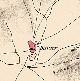
Burayr was a Palestinian Arab village in the Gaza Subdistrict, 18 kilometers (11 mi) northeast of Gaza City. Its population in 1945 was 2,740 and it was depopulated during the 1948 Palestine war as part of the 1948 Palestinian expulsion and flight. It had an average elevation of 100 meters (330 ft).

Karatiyya was a Palestinian Arab village of 1,370, located 29 kilometers (18 mi) northeast of Gaza, situated in a flat area with an elevation of 100 meters (330 ft) along the coastal plain of Palestine and crossed by Wadi al-Mufrid.

Dimra was a small Arab village located 11 kilometres (6.8 mi) northeast of Gaza City in British Palestine. Ancient remains at the site attest to a long-time human settlement there; during the Mamluk era, the town was the home of the Bani Jabir tribe. It was depopulated during the 1948 Arab–Israeli War, and is now the site of Erez, a kibbutz in Israel.

Bayt Tima was a Palestinian Arab village in the Gaza Subdistrict, located 21 kilometers (13 mi) northeast of Gaza and some 12 kilometers (7.5 mi) from the coastline. It was situated in flat terrain on the southern coastal plain of Palestine. Bayt Tima was depopulated during the 1948 Arab-Israeli War. Its population in 1945 was 1,060.

Al-Sawafir al-Shamaliyya was a Palestinian Arab village in the Gaza Subdistrict, located 33 kilometers (21 mi) northeast of Gaza situated along the southern coastal plain of Palestine 50 meters (160 ft) above sea level. It was one of three namesake villages, alongside Al-Sawafir al-Sharqiyya and Al-Sawafir al-Gharbiyya.

Al-Batani al-Sharqi was a Palestinian Arab village in the Gaza Subdistrict, located 36.5 kilometers (22.7 mi) northeast of Gaza situated in the flat terrain on the southern coastal plain of Palestine. It had a population of 650 in 1945. Al-Batani al-Sharqi was depopulated during the 1948 Arab-Israeli War.

Tall al-Turmus was a Palestinian Arab village in the Gaza Subdistrict, located on a low hill on the coastal plain of Palestine, 38 kilometers (24 mi) northeast of Gaza. In 1945, it had a population of 760 and a land area of 11,508 dunams. The village was depopulated during the 1948 Arab-Israeli War.

Al-Batani al-Gharbi was a Palestinian village in the Gaza Subdistrict. It was depopulated during the 1947–48 Civil War in Mandatory Palestine on May 13, 1948, by the Giv'ati Brigade under Operation Barak. It was located 36 km (22 mi) northeast of Gaza.
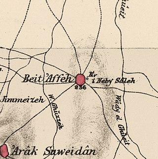
Bayt 'Affa was a Palestinian village in the Gaza Subdistrict. It was depopulated and destroyed during the 1947–48 Civil War in Mandatory Palestine. It was located 29 km (18 mi) northeast of Gaza and Wadi al-Rana ran east of the village.

Bil'in was a Palestinian Arab village in the Gaza Subdistrict. It was depopulated by the Israel Defense Forces during the 1948 Arab–Israeli War on July 8, 1948, under Operation An-Far. It was located 39 km northeast of Gaza and the village contained two wells which supplied it with drinking water.
Hulayqat was a Palestinian Arab village in the Gaza Subdistrict. It was depopulated during the 1947–1948 Civil War in Mandatory Palestine. It was located 20.5 km northeast of Gaza.

Al-Sawafir al-Gharbiyya was a Palestinian Arab village in the Gaza Subdistrict. It was depopulated during the 1948 War on May 18, 1948, during the second stage of Operation Barak. It was located 30 km northeast of Gaza city. It was one of three namesake villages, alongside Al-Sawafir al-Sharqiyya and Al-Sawafir al-Shamaliyya.

Al-Maghar was a Palestinian Arab village in the Ramle Subdistrict of Mandatory Palestine. It was depopulated by the Givati Brigade during Operation Barak on 18 May 1948. It was located 12 km southwest of Ramla, situated north of Wadi al-Maghar.

Al-Mansura was a small Palestinian Arab village in the Ramle Subdistrict, located 10 km south of Ramla. It was depopulated during the 1947–48 Civil War in Mandatory Palestine on April 20, 1948, under Operation Barak.

Al-Mukhayzin was a Palestinian village in the Ramle Subdistrict. It was ethnically cleansed during the Nakba on April 20, 1948, by the Givati Brigade of Operation Har'el. It was located 10 km southwest of Ramla.
 1870s map
  1940s map
 modern map
  1940s with modern overlay map


