Al-Jiyya

Last updated

Contents

al-Jiyya
الجية
al-Jeya, al-Jiya, Ed-Deir, Ejjeh
Village
Etymology: "water collector" [1] [2]
Historical map series for the area of al-Jiyya (1870s).jpg 1870s map
Historical map series for the area of al-Jiyya (1940s).jpg 1940s map
Historical map series for the area of al-Jiyya (modern).jpg modern map
Historical map series for the area of al-Jiyya (1940s with modern overlay).jpg 1940s with modern overlay map
A series of historical maps of the area around Al-Jiyya (click the buttons)
Mandatory Palestine location map.svg
Red pog.svg
al-Jiyya
Location within Mandatory Palestine
Coordinates: 31°37′46″N34°35′53″E / 31.62944°N 34.59806°E / 31.62944; 34.59806
Palestine grid 111/115
Geopolitical entity Mandatory Palestine
Subdistrict Gaza
Date of depopulationNovember 4–5, 1948 [3]
Area
  Total
8,506 [4]   dunams (8.5 km2 or 3.3 sq mi)
Population
 (1945)
  Total
1,230 [5] [4]
Cause(s) of depopulationMilitary assault by Yishuv forces
Current Localities Beit Shikma, [6] Ge'a [7] [8]

al-Jiyya (Arabic : الجية, also transliterated Algie) was a Palestinian village that was depopulated during the 1948 Arab-Israeli War. It was located 19 kilometers northeast of Gaza City and had a population of 1,230, according to a 1945 survey. [5] The village was occupied by Israel's Giv'ati Brigade on 4 November 1948 during Operation Yoav.

History

The village was situated on a sandy spot, surrounded by hills, on the southern coastal plain. Several wadis descended around it and it was periodically subjected to flooding. This, perhaps, explains its name, which means "water collector" in Arabic. [1] [9] The village has been identified with a town referred to in the Crusader records as "Algie". [1]

Among the archaeological remains found in al-Jiyya were a stone column and the remains of a Roman mill. [1]

Ottoman era

During the 17th and 18th centuries, the area of al-Jiya experienced a significant process of settlement decline due to nomadic pressures on local communities. The residents of abandoned villages moved to surviving settlements, but the land continued to be cultivated by neighboring villages. [10] The villagers reported that their village had been ruined at one point and then rebuilt by Muhammed Aby Nabbut, the governor of Jaffa and Gaza between 1807 and 1818. [1]

In 1838, Edward Robinson noted it under the name of Eljieh; located in the Gaza district. [11]

In 1863 the French explorer Victor Guérin called the village Ed-Deir, and he estimated it had three hundred and fifty inhabitants. Near the wells he saw several parts of columns and one Corinthian capital, all made of gray-white marble. He further noted sycamores, pines and acacias mimosas, at intervals, in the middle of tobacco plantations. [12] In 1883, the PEF's Survey of Western Palestine called it Ejjeh, and described it as "a moderate-sized mud village, with a pool to the north. On the east is a Sebil, or drinking-fountain. Beside the road to the west are olive groves." [13]

British Mandate era

In the 1922 census of Palestine, conducted by the British Mandate authorities, Jiya had a population of 776 inhabitants, all Muslims, [14] increasing in the 1931 census to 889, still all Muslims, in 188 houses. [15]

Al-Jiyya's population had its own mosque. The children attended school in the neighboring village of Barbara. The villagers installed a pump on one of the wells in the area to draw water for domestic use. [16] The villagers worked primarily in agriculture, planting various types of grain, especially corn. Al-Jiyya was known for its cheese and dairy products, which were sold in Gaza and in Majdal. [17]

al Jiyya 1931 1:20,000 Al Jiyya1931.jpg
al Jiyya 1931 1:20,000
al Jiyya 1945 1:250,000 Ashkelon 1945.jpg
al Jiyya 1945 1:250,000

In the 1945 statistics El Jiya had a population of 1,230, all Muslims, [5] with a total of 8,506 dunams of land, according to an official land and population survey. [4] Of this, a total of 189 dunums was used for citrus and bananas, while 8,004 dunumus were allocated to cereals and 26 dunums were irrigated or used for orchards, [1] [18] while 45 dunams were built-up land. [19]

1948 War, and aftermath

The village was captured by Israel's Giv'ati Brigade on 4 November 1948 during Operation Yoav. At the end of November 1948, Coastal Plain District troops carried out sweeps of the villages around and to the south of Majdal. Al-Jiyya was one of the villages named in the orders to the IDF battalions and engineers platoon, that the villagers were to be expelled to Gaza, and the IDF troops were "to prevent their return by destroying their villages". The path leading to the village was to be mined. The IDF troops were ordered to carry out the operation "with determination, accuracy and energy". [20] The operation took place on 30 November. The troops found "about 40" villagers in Barbara and al-Jiyya, "composed of women, old men and children", who offered no resistance. They were expelled to Beit Hanun, in the northern Gaza strip. Eight young men who were found were sent to a POW camp. [21]

Following the war the area was incorporated into the State of Israel. Palestinian historian Walid Khalidi stated in 1992 that there were no traces of the village remaining and that the residents of moshav Beit Shikma had planted cantaloupes on the land. [1]

See also

Related Research Articles

<span class="mw-page-title-main">Bayt Jirja</span> Place in Gaza, Mandatory Palestine

Bayt Jirja or Beit Jerja was a Palestinian Arab village 15.5 km Northeast of Gaza. In 1931 the village consisted of 115 houses. It was overrun by Israeli forces during operation Yo'av in the 1948 Arab-Israeli war. Bayt Jirja was found depopulated in November 1948, during "clean up sweeps" to expel any partial inhabited villages and destroy village housing to prevent any possible re-occupation in the area. The village was completely destroyed after the occupation and only one tomb remains.

<span class="mw-page-title-main">Ra'na</span> Place in Hebron, Mandatory Palestine

Ra'na was a village located approximately 26 km northwest of Hebron. It was occupied by the Israeli army during Operation Yo'av in October 1948. It was one of 16 villages in the Hebron district that were depopulated.

<span class="mw-page-title-main">Bayt Daras</span> Palestinian village depopulated in 1948

Bayt Daras was a Palestinian Arab town located 46 kilometers (29 mi) northeast of Gaza and approximately 50 meters (160 ft) above sea level. The village was depopulated and destroyed during the 1948 Palestine war, as part of the 1948 Palestinian expulsion and the Nakba.

<span class="mw-page-title-main">Qatra</span> Place in Ramle, Mandatory Palestine

Qatra was a Palestinian Arab village in the Ramle Subdistrict, located 15 kilometers (9.3 mi) southwest of the city of Ramla and 40 kilometers (25 mi) west of Jerusalem, some 50 meters (160 ft) above sea level. It was depopulated in May 1948.

<span class="mw-page-title-main">Barbara, Gaza</span> Former village in Gaza subdistrict

Barbara was a Palestinian Arab village in the Gaza Subdistrict located 17 km northeast of Gaza city, in the vicinity of modern Ashkelon. It had an entirely Arab population of 2,410 in 1945. The village consisted of nearly 14,000 dunums of which approximately 12,700 dunums was able to be cultivated. It was captured by Israel during the 1948 Arab–Israeli War.

<span class="mw-page-title-main">Al-Jura</span> Place in Gaza, Mandatory Palestine

Al-Jura was a Palestinian village that was depopulated during the 1948 Arab-Israeli war, located immediately adjacent to the towns of Ashkelon and the ruins of ancient Ascalon. In 1945, the village had a population of approximately 2,420 mostly Muslim inhabitants. Though defended by the Egyptian Army, al-Jura was nevertheless captured by Israel's Givati Brigade in a November 4, 1948, offensive as part of Operation Yoav.

<span class="mw-page-title-main">Qastina</span> Village in Gaza, Mandatory Palestine

Qastina was a Palestinian village, located 38 kilometers northeast of Gaza City. It was ethnically cleansed during the 1948 Arab-Israeli war.

<span class="mw-page-title-main">Jimzu</span> Place in Ramle, Mandatory Palestine

Jimzu, also known as Gimzo, was a Palestinian village, located three miles southeast of Lydda. Under the 1947 UN Partition Plan of Mandatory Palestine, Jimzu was to form part of the proposed Arab state. During the 1948 Arab–Israeli War, the village was depopulated in a two-day assault by Israeli forces.

<span class="mw-page-title-main">Simsim, Gaza</span> Place in Gaza, Mandatory Palestine

Simsim, also spelled Semsem or Sumsum, was a Palestinian village, located 15 kilometers (9.3 mi) northeast of Gaza. It was depopulated and destroyed during the 1948 Palestine war as part of the 1948 Palestinian expulsion and the Nakba.

<span class="mw-page-title-main">Salama, Jaffa</span> Place in Jaffa, Mandatory Palestine

Salamah was a Palestinian Arab village, located five kilometers east of Jaffa, that was depopulated in the lead-up to the 1948 Arab-Israeli War. The town contains the supposed grave of Salama Abu Hashim, a companion of the Islamic prophet Muhammad. His tomb, two village schools, and ten houses from among the over 800 houses that had made up the village, are all that remain of the structures of the former village today.

<span class="mw-page-title-main">Qannir</span> Village in Haifa, Mandatory Palestine

Qannir was a Palestinian village, located 35 kilometers south of Haifa. With 750 inhabitants in 1945, it was depopulated in the lead up to the 1948 Arab-Israeli war.

<span class="mw-page-title-main">Idnibba</span> Place in Ramle, Mandatory Palestine

Idnibba was a Palestinian village, located at latitude 31.7426937N and longitude 34.8561001,E in the southern part of the Ramle Subdistrict. It was depopulated in 1948, at which time its population was 568, and its lands are now used by Kfar Menahem.

<span class="mw-page-title-main">Najd, Gaza</span> Place in Gaza, Mandatory Palestine

Najd was a Palestinian Arab village, located 14 kilometers (8.7 mi) northeast of Gaza City. During the British Mandate in Palestine, children from Najd attended school in the nearby village of Simsim. On 13 May 1948, Najd was occupied by the Negev Brigade as part of Operation Barak, and the villagers were expelled.

<span class="mw-page-title-main">Burayr</span> Place in Gaza, Mandatory Palestine

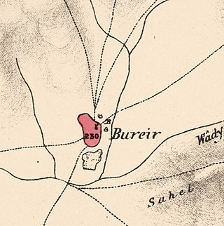
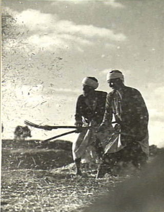
Burayr was a Palestinian Arab village in the Gaza Subdistrict, 18 kilometers (11 mi) northeast of Gaza City. Its population in 1945 was 2,740 and it was depopulated during the 1948 Palestine war as part of the 1948 Palestinian expulsion and flight. It had an average elevation of 100 meters (330 ft).

<span class="mw-page-title-main">Al-Sawafir al-Shamaliyya</span> Place in Gaza, Mandatory Palestine

Al-Sawafir al-Shamaliyya was a Palestinian Arab village in the Gaza Subdistrict, located 33 kilometers (21 mi) northeast of Gaza situated along the southern coastal plain of Palestine 50 meters (160 ft) above sea level. It was one of three namesake villages, alongside Al-Sawafir al-Sharqiyya and Al-Sawafir al-Gharbiyya.

<span class="mw-page-title-main">Bayt 'Affa</span> Place in Gaza, Mandatory Palestine

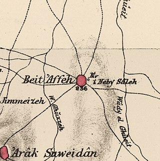
Bayt 'Affa was a Palestinian village in the Gaza Subdistrict. It was depopulated and destroyed during the 1947–48 Civil War in Mandatory Palestine. It was located 29 km (18 mi) northeast of Gaza and Wadi al-Rana ran east of the village.

<span class="mw-page-title-main">Ni'ilya</span> Place in Gaza, Mandatory Palestine

Ni'ilya was a Palestinian village in the Gaza Subdistrict. It was depopulated during the 1948 Arab–Israeli War on November 4, 1948, under Operation Yo'av. It was located 19 km northeast of Gaza in the city territory of modern Ashkelon. The village was defended by the Egyptian Army.

<span class="mw-page-title-main">Al-Sawafir al-Gharbiyya</span> Place in Gaza, Mandatory Palestine

Al-Sawafir al-Gharbiyya was a Palestinian Arab village in the Gaza Subdistrict. It was depopulated during the 1948 War on May 18, 1948, during the second stage of Operation Barak. It was located 30 km northeast of Gaza city. It was one of three namesake villages, alongside Al-Sawafir al-Sharqiyya and Al-Sawafir al-Shamaliyya.

<span class="mw-page-title-main">Mughallis</span> Village in Hebron, Mandatory Palestine

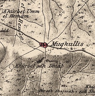
Mughallis was a Palestinian Arab village located 30.5 kilometers (19.0 mi) northwest of Hebron. It was depopulated during the 1948 Arab-Israeli War between July 9–10, 1948 as part of Operation An-Far.

<span class="mw-page-title-main">Arab al-Shamalina</span> Place in Safad, Mandatory Palestine

Arab al-Shamalina also known as Khirbat Abu Zayna was a Palestinian Arab village in the Safad Subdistrict. It was depopulated during the 1947–1948 Civil War in Mandatory Palestine on May 4, 1948, under Operation Matate (Broom), a sub operation of Operation Yiftach. It was located 13 km southeast of Safad near the Jordan River.

References

  1. 1 2 3 4 5 6 7 Khalidi, 1992, p.114
  2. but meaning "confusion" according to Palmer, 1881, p. 367
  3. Morris, 2004, p. xix, village #311; Also gives the cause for depopulation
  4. 1 2 3 Government of Palestine, Department of Statistics. Village Statistics, April, 1945. Quoted in Hadawi, 1970, p. 45 Archived 2015-09-24 at the Wayback Machine
  5. 1 2 3 Department of Statistics, 1945, p. 31
  6. In 1950, according to Khalidi, 1992, p.114
  7. Morris, 2004, p. xxi: settlement #60, 1949.
  8. In 1949, according to Khalidi, 1992, p.114
  9. but "confusion" according to Palmer, 1881, p. 367
  10. Marom, Roy; Taxel, Itamar (1 January 2023). "Ḥamāma: The historical geography of settlement continuity and change in Majdal 'Asqalān's hinterland, 1270 - 1750 CE". Journal of Historical Geography. 82: 49–65. doi: 10.1016/j.jhg.2023.08.003 .
  11. Robinson and Smith, vol 3, 2nd appendix, p. 118
  12. Guérin, 1869, p. 173
  13. Conder and Kitchener, 1883, SWP III, pp. 259-260
  14. Barron, 1923, Table V, Sub-district of Gaza, p. 8
  15. Mills, 1932, p. 4.
  16. Hammad, ´Abd al-Qadir Ibrahim (1990): "Al-Jiyya." Al-Bayader Assiyasi, No. 398 (5 May 1990) p. 68. Cited in Khalidi, 1992, p.114
  17. Hammad, cited in Khalidi, 1992, p.114
  18. Government of Palestine, Department of Statistics. Village Statistics, April, 1945. Quoted in Hadawi, 1970, p. 87
  19. Government of Palestine, Department of Statistics. Village Statistics, April, 1945. Quoted in Hadawi, 1970, p. 137
  20. Coastal Plain District HQ to battalions 151 and ´1 Volunteers`, etc., 19:55 hours, 25 Nov. 1948, IDFA (=Israeli Defence Forces and Defence Ministry Archive) 6308\49\\141. Cited in Morris, 2004, p. 517
  21. Coastal Plain HQ to Southern Front\Operations, 30 Nov. 1948, IDFA 1978\50\\1; and Southern Front\Operations to General Staff Divisions, 2. Dec. 1948, IDFA 922\75\\1025. Cited in Morris, 2004, p. 518

Bibliography