al-Khalisa الخالصة al-Khalsa | |
---|---|
![]() The mosque of al-Khalisa, currently a museum for the history of Kiryat Shemona | |
Etymology: Pure, sincere [1] | |
A series of historical maps of the area around Al-Khalisa (click the buttons) | |
Location within Mandatory Palestine | |
Coordinates: 33°12′52″N35°34′02″E / 33.21444°N 35.56722°E | |
Palestine grid | 203/290 |
Geopolitical entity | Mandatory Palestine |
Subdistrict | Safad |
Date of depopulation | May 11, 1948 [2] [3] |
Area | |
• Total | 11,280 dunams (11.3 km2 or 4.4 sq mi) |
Population (1945) | |
• Total | 1,840 [4] [5] |
Cause(s) of depopulation | Influence of nearby town's fall |
Secondary cause | Whispering campaign |
Current Localities | Kiryat Shemona |
Al-Khalisa was a Palestinian Arab village situated on a low hill on the northwestern edge of the Hula Valley of over 1,800 located 28 kilometers (17 mi) north of Safad. It was depopulated in the 1948 Palestine war.
Al-Khalisa was founded by the Bedouin from the 'Arab al-Ghawarina clan, who constituted the bulk of the village's population. Under the Ottoman Empire, in the 1596 tax records, it had a population of 29 Muslim households, an estimated 160 persons, and was under the administration of the nahiya ("subdistrict") of Jira, part of Sanjak Safad. The villagers paid a fixed tax rate of 25% on various agricultural products, including wheat, barley, orchards, beehives, in addition to water buffalos and a water-powered mill; a total of 5,449 akçe. [6] [7]
In 1875, Victor Guérin traveled in the region, and noted about Al-Khalisa (which he called Khalsah): "At the bottom and west of this tell, is a small village of very recent foundation, called Khalsah; it was built on the site and partly with the materials of another older one. The gardens that surround it are watered by the waters of l'A'ïn Dahab." [8] In 1881, the PEF's Survey of Western Palestine described al-Khalisa as a village built of stone, surrounded by streams, with a population of 50. [9]
The houses of the village were built of bricks and basalt stones cut from the hillside. Al-Khalisa had a boys' elementary school which also admitted students from neighboring villages. The residents drew their drinking water from several springs. [2] It was one of five villages in the Galilee to be governed by a village council that administered in local affairs. [10]
The leader of 'Arab al-Ghawarina clan was Sheikh Kamal Hussein al-Youssef, [11] resident of Al-Khalisa, his forefathers controlled the Hula Valley from the 17th century. [12] According to Meron Benvenisti, he led the raid on Tel Hai in 1920 while searching for Frenchmen. In the years preceding 1948, Sheikh Kamal established close relationships with the Jewish settlers, contributed to the establishment of Jewish settlements in the Hula Valley by helping them buy land, selling land to the Jewish National Fund, [13] maintain peace and security, particularly during the 1936-9 revolt. He also joined the British during World War II to help defeat the Nazis from the French Vichy regime in Syria. [12] But, according to Benvenisti, the veterans of Kfar Giladi did not forget or forgive, and cultivated Sheikh Kamal's enemy Emir Faour. [14] In March 1949, after the Nakba, Sheikh Kamal reported on the Palestinians refugee’s state of mind: “All the refugees in Lebanon want to return. None of them have settled down; they’re not allowed to work, particularly not agricultural work. The Red Cross organization in Lebanon which is staffed entirely by Lebanese officials is stealing all it can; very little reaches the refugees.” Sheikh Kamal Hussein al-Youssef was murdered in 1949 by a Syrian intelligence agent. [13]
In the 1931 census of Palestine, the population of El Khalisa was 1,369; 1,340 Muslims, 3 Jews and 26 Christians, in a total of 259 houses. [15]
In the 1945 statistics, its population was 1,840, of which 20 were Christians, [4] and the total land area were 11,280 dunams. [2] [16] Of this, 5,586 dunams were irrigated or used for plantations, 3,775 for cereals, [17] while 20 dunams were classified as urban land. [18]
The residents of al-Khalisa fled their homes on 11 May 1948 following the rejection of approaches made by them to the Haganah asking for an "agreement". [19] According to Yigal Allon, the commander of Operation Yiftach, the villagers left following his Whispering Campaign. This involved instructing the leaders of Jewish villages in the area to warn their neighbours that "a great Jewish reinforcement has arrived in Galilee and that it is going to burn all the villages of the Huleh." Post-war IDF analysis seems to undermine this claim. Allon himself writes that the fall of Safad and the success of Operation Matateh were also reasons for the villagers departure. He describes them as some of "the tens of thousands of sulky Arabs who remained in Galilee." He also states that "The building of the police station at Halsa (al-Khalisa) fell into our hands without a shot." [20] [21]
The village's residents stated that after they fled, only the local militia remained, but withdrew after shelling from the Jewish town of Manara and after seeing an armored unit approaching al-Khalisa. [22] Former villagers, interviewed in Tel al-Zaatar camp in Lebanon in 1973, recounted that when they returned to the village;
We found that the Jews had burned and destroyed the houses belonging to Ali Zakayan, Abu Ali Muhammad Hamadih, Mustafa al-Haj Yusif, Issa Muhammad, Ali Salih Ahmad, Muhammad Arab al-Haj Mahmud, Salih Ismail, Sari al-Khadir, Dawud Hussein, Abdul-Raziq Hamid, Qassim Muhammead al-Salih and Ali Hussein Mahmud ... The village was in ruins. [23]
According to Walid Khalidi, 1992, "stone rubble from the houses markes the site. The school and the Mandate government´s office buildings stand abandoned, as does the village mosque and minaret. The level land surrounding the site is cultivated by settlement of Qirat Shemona, while the mountainous areas are either used as pastures or are wooded." [2]
According to Meron Benvenisti, 2000, "the mosque of al-Khalsa, one of the few structures that remain of that Galilee Arab village, is situated in a municipal park in the older section of the Jewish town of Kiryat Shemona. It serves as the local museum dedicated to the memory of townspeople who have fallen in Israel's various wars." [24]
Dayr al-Qassi or Deir el-Qasi, was a Palestinian Arab village located 26 km northeast of the city of Acre, which was depopulated during 1948 Arab-Israeli war.
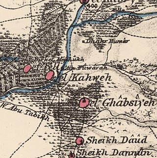
Al-Ghabisiyya was a Palestinian Arab village in northern Palestine, 16 km north-east of Acre in present-day Israel. It was depopulated by the Israel Defense Forces during the 1948 Palestinian expulsion and remains deserted.
Kafr ʿInān, is a former Palestinian village, depopulated in the 1948 Arab–Israeli war. It was located around 33 kilometres (21 mi) east of Acre.
Marus was a Palestinian village in Upper Galilee, 7 km northeast of Safad. In the Roman and medieval period it had Jewish population, and by the 16th century it became entirely Muslim. After a period of desertion, the Ottoman authorities resettled it with Algerian Arabs in the 19th century. It was depopulated in 1948 during the Operation Hiram by the Israeli attacking brigade Sheva' Brigade.
Safsaf was a Palestinian village 9 kilometres northwest of Safed, present-day Israel. Its villagers fled to Lebanon after the Safsaf massacre in October 1948, during the 1948 Arab–Israeli War.
Sa'sa' was a Palestinian village, located 12 kilometres northwest of Safed, that was depopulated by Israeli forces during the 1948 Arab-Israeli war. The village suffered two massacres committed by Haganah forces: one in mid-February 1948 and the other at the end of October the same year. Its place has been taken since 1949 by Sasa, an Israeli kibbutz.
Ammuqa was a Palestinian village, located five kilometres northeast of Safed.
Ein al-Zeitun, was a Palestinian Arab village, located 1.5 kilometres (0.93 mi) north of Safed in the Upper Galilee. During the early Ottoman period, Ein el-Zeitun had a mixed population of Muslims and Jews. Later, in the 19th century, it became entirely Muslim. The village's small population and land area as well as its proximity to Safad made it a suburb of the city. In 1945, the village had a population of 820 inhabitants and a total land area of 1,100 dunams. The village was depopulated in 1948, after the Ein al-Zeitun massacre.
Farradiyya was a Palestinian Arab village of 670 located 8 kilometers (5.0 mi) southwest of Safad, A Jewish settlement called 'Farod' was built atop the once ruined village.
Abil al-Qamh was a Palestinian village located near the Lebanese border north of Safad. It was depopulated in 1948. It was located at the site of the biblical city of Abel-beth-maachah.
'Akbara is an Arab village in the Israeli municipality of Safed, which included in 2010 more than 200 families. It is 2.5 km south of Safed City. The village was rebuilt in 1977, close to the old village destroyed in 1948 during the 1947–1949 Palestine war.
Al-Ja'una or Ja'ouna, was a Palestinian village situated in Galilee near al-Houleh Plateau, overlooking the Jordan Valley. The village lay on a hillside 450–500 meters above sea level, 5 kilometers east of Safad near a major road connecting Safad with Tabariya. The village had its Arab residents expelled by Zionist forces in 1948 and was thereafter resettled by Jews, becoming a part of the Israeli settlement of Rosh Pinna.
Biriyya was a Palestinian Arab village in the Safad Subdistrict. It was depopulated during the 1947–1948 Civil War in Mandatory Palestine on May 2, 1948, by The Palmach's First Battalion of Operation Yiftach. It was located 1.5 kilometres (0.9 mi) northeast of Safad. Today the Israeli moshav of Birya includes the village site.
Al-Buwayziyya was a Palestinian Arab village in the Safad Subdistrict. It was depopulated during the 1947–1948 Civil War in Mandatory Palestine on May 11, 1948, by the Palmach's First Battalion of Operation Yiftach. It was located 22 km northeast of Safad.
Fara was a Palestinian Arab village in the Safad Subdistrict. It was depopulated during the 1948 Arab-Israeli War on October 30, 1948, under Operation Hiram. It was located 11.5 km north of Safad on the Wadi al-Fara.
Qabba'a was a Palestinian Arab village in the District of Safad. It was depopulated during the 1948 War on May 26, 1948, by the Palmach's First Battalion of Operation Yiftach. It was located 6 km northeast of Safad.
Al-Zahiriyya al-Tahta was a Palestinian Arab village in the Safad Subdistrict. The village was on a descent at the southwestern part of Safad, a town 1 kilometer (0.62 mi) east of the village. Possibly named after the Mamluk sultan al-Zahir Baybars, the village was incorporated into the Safad Sanjak of the Ottoman Empire in 1517, and its entirely Muslim population paid fixed taxes, as well as taxes on winter pastures, an olive oil or grape syrup press and beehives during the 16th century. By the late 19th century, the population grew to 335 inhabitants, all Muslims. The population remained about the same in the last years of British Mandatory rule. The village lands spanned 6,773 dunums, nearly half of which were used to grow grains, the residents living on 28 dunums. Al-Zahiriyya al-Tahta was depopulated during the 1948 Palestine War when its inhabitants fled shortly after the capture of Safed by Jewish paramilitary forces.
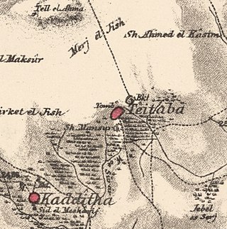
Taytaba was a Palestinian-Arab village in the Safad Subdistrict, located 5 kilometers north of Safad. It was depopulated during the 1947–1948 Civil War in Mandatory Palestine in May 1948 under Operation Hiram. In 1945 it had a population of 530 and a total area of 8,453 dunams, 99.8% of which was Arab-owned.
Al-'Ulmaniyya was a Palestinian Arab village in the Safad Subdistrict. It was depopulated during the 1947–1948 Civil War in Mandatory Palestine on April 20, 1948, by the Palmach's First Battalion of Operation Yiftach. It was located 14.5 km northeast of Safad.
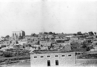
Hadatha, also El Hadetheh or Hadateh, was a Palestinian Arab village in the District of Tiberias, located 12.5 km southwest of Tiberias. It was depopulated in the 1947–1948 civil war in Mandatory Palestine.