Khirbat Karraza

Last updated • 5 min readFrom Wikipedia, The Free Encyclopedia
Khirbat Karraza or Chorazin
Village
Korazim-view.jpg
Ancient synagogue at Chorazin
Historical map series for the area of Khirbat Karraza (1870s).jpg 1870s map
Historical map series for the area of Khirbat Karraza (1940s).jpg 1940s map
Historical map series for the area of Khirbat Karraza (modern).jpg modern map
Historical map series for the area of Khirbat Karraza (1940s with modern overlay).jpg 1940s with modern overlay map
A series of historical maps of the area around Khirbat Karraza (click the buttons)
Israel outline northeast.png
Red pog.svg
Khirbat Karraza or Chorazin
Location within Israel northeast
Coordinates: 32°54′40″N35°33′46″E / 32.91111°N 35.56278°E / 32.91111; 35.56278 Coordinates: 32°54′40″N35°33′46″E / 32.91111°N 35.56278°E / 32.91111; 35.56278
Date of depopulationMay 4, 1948

Chorazin (Greek : Χοραζίν /kˈrzɪn/ ; also Chorazain) or Korazim (Hebrew : כורזים; also Chorizim) was an ancient village in the Roman and Byzantine periods, best known from the Christian Gospels. It stood on the Korazim Plateau in the Galilee on a hill above the northern shore of the Sea of Galilee, two and a half miles from Capernaum.

Contents

Khirbat Karraza (also Karraza, Kh. Karazeh, Kerazeh) was an Arab village established at the site of the ancient village and depopulated during the 1947–1948 Civil War in Mandatory Palestine on May 4, 1948 by the Palmach's First Battalion during Operation Yiftach. It was located 8.5 km southeast of Safad.

The nearby Israeli town of Korazim is named for this location.

History

Two settlement phases[ which? ] have been proposed based on coin and pottery findings. [1] The town was partially destroyed in the 4th century, possibly as a result of an earthquake. [2] The settlement of Khirbat Karraza subsequently developed on the site.

Khirbat Karraza in the PEF Survey of Palestine Khirbat Karraza in the Survey of Western Palestine 1880.06 (cropped).jpg
Khirbat Karraza in the PEF Survey of Palestine

During Ottoman control, Khirbat Karraza was populated by the Zanghariyya Bedouin tribe and the village contained a shrine for a local Muslim saint, al-Shaykh Ramadan. The villagers used to store grain close to the shrine, certain that nobody would steal it and thereby violate the sanctity of the shrine. [3]

The Palestinian historian Walid Khalidi described the site in 1992: "Some village houses still stand, together with the remains of other houses. One of the old houses has been renovated. Also remaining is the tomb of Shaykh Ramadan, around which the village shrine had been built. The tomb is collapsing and the building in which it was housed no longer exists. It is surrounded by large carob trees." [3]

Archaeological excavations

Extensive excavations and a survey were carried out in 1962-1964. Excavations at the site were resumed in 1980-1987.

In 2004, a small-scale salvage excavation was conducted by the Israel Antiquities Authority along the route of an ancient road north of Moshav Amnun. In the literature, the road is referred to as "the way through Korazim." It crossed the Chorazin plateau from west to east, branching off from the main Cairo–Damascus road that ran northeast toward Daughters of Jacob Bridge. [4] The main settlement dates to the 3rd and 4th centuries. The majority of the structures found were made from basalt, a black volcanic rock found locally. [5] The town's ruins are spread over an area of 25 acres (100,000 m2), subdivided into five separate quarters, with a synagogue in the centre. Close by is a ritual bath (mikvah), surrounded by public and residential buildings. The handful of olive millstones used in olive oil extraction found suggest a reliance on the olive for economic purposes, like a number of other villages in ancient Galilee.

Synagogue

Decorated stone from the synagogue PikiWiki Israel 19487 Decorated stone form Chorazin synagogue bazalt 4.JPG
Decorated stone from the synagogue

The only synagogue visible today was built in the late 3rd century, destroyed in the 4th century, and rebuilt in the 6th century. [6]

The large, impressive synagogue which was built of basalt stones and decorated with Jewish motifs is the most striking of the surviving structures. An unusual feature in an ancient synagogue is the presence of three-dimensional sculpture, a pair of stone lions. A similar pair of three-dimensional lions was found in the synagogue at Kfar Bar'am. [7] Other carvings, which are thought to have originally been brightly painted, feature images of wine-making, animals, a Medusa, an armed soldier, and an eagle. [8] In 1926, archaeologists discovered a "Seat of Moses," carved from a basalt block. According to the New Testament, this is where the reader of the Torah sat ( Matthew 23:1-3 ). [9]

Jacob Ory, who excavated the site in 1926 on behalf of the British Mandate Department of Antiquities, wrote about a second synagogue ca. 200 m west of the first one, and he described it in detail. Later excavations, however, have not been able to find the remains noted by him. [10]

Appearance in religious texts

Chorazin, along with Bethsaida and Capernaum, was named in the Christian gospels of Matthew and Luke as cities in which the Judaean preacher Jesus of Nazareth performed his mission. However, because these towns seeingly rejected his message ("they had not changed their ways"), they were subsequently cursed (Matthew 11:20–24; Luke 10:13–15). Due to this condemnation, the influential but non-canonical Apocalypse of Pseudo-Methodius predicted that the Antichrist would be conceived in Chorazin. [11]

The English theologian John Lightfoot writing in the 17th century suggested that Chorazin might have referred to a wider area around Cana in Galilee, rather than a single city/village:

What if, under this name, Cana be concluded, and some small country adjacent, which, from its situation in a wood, might be named "Chorazin", that is, 'the woody country'? Cana is famous for the frequent presence and miracles of Christ. But away with conjecture, when it grows too bold. [12]

The Jewish Babylonian Talmud (redacted until c. 475) mentions that Chorazin was a town specifically known for its grain (Menahot, 85a). [9]

In his Biblical Researches in Palestine in the mid-nineteenth century, Edward Robinson visited Khirbat Karraza, but concluded it was not the Biblical Chorazin, because the ruins were not significant enough and the site was not near the shore of the Sea of Galilee, as stated by Jerome (Lacum Genesareth, in cujus litore Capernaum et Tiberias et Bethsaida et Chorozaim sitæ sint): [13]

The ruins we had been told of lie on the west side of this same valley, a quarter of a mile southwest, near its entrance into the main Wady. They consist simply of a few foundations of black stones ; the remains evidently of a poor and inconsiderable village. They are known as Khirbet Kerâzeh. We did not go to them, as there was no path; and because they were in full view. Their distance from Tell Hùm must be reckoned at about three miles. We had come to this spot, because the name Kerázeh bears a degree of resemblance to the Chorazin of the New Testament; and we hoped to find, in the ruins or the situation, something which might determine the position of that ancient place. In this we felt ourselves disappointed. The remains are too trivial to have ever belonged to a place of any importance. Chorazin, too, according to Jerome, lay upon the shore of the lake; but this site is an hour distant. shut in among the hills, without any view of the lake, and remote from any public road whether ancient or modern.

Olive oil press Old oil-press In Korazim.jpg
Olive oil press
"Seat of Moses" made of basalt from the synagogue Chorazin Synagogue - Stone Seat.jpg
"Seat of Moses" made of basalt from the synagogue
House ruin with "Chorazin windows" Korazim-view-1.jpg
House ruin with "Chorazin windows"

Wider references

The writer M.R. James mentions "Chorazin" as a place of ill-repute and a location on "the black pilgrimage", in his 1904 short story, "Count Magnus".

See also

Related Research Articles

Kafr Inan Place in Acre, Mandatory Palestine

Kafr ʿInān, was a Palestinian Arab village in the Acre Subdistrict around 33 kilometres (21 mi) east of Acre. Until 1949, it was an Arab village built over the ruins of ancient Kefar Hanania. Archaeological surveys indicate Kefar Hanania was founded in the Early Roman period, and was inhabited through the Byzantine period. It was resettled in the Middle Ages and the modern era.

Marus Place in Safad, Mandatory Palestine

Marus was a Palestinian village in Upper Galilee, 7 km northeast of Safad. In the Roman and medieval period it had Jewish population, and by the 16th century it became entirely Muslim. After a period of desertion, it was resettled by Algerian Arabs. It was depopulated in 1948 during the Operation Hiram by the Israeli attacking brigade Sheva' Brigade.

Capernaum Village at Lake Tiberias in the north of historical Judea, associated with Jesus

Capernaum was a fishing village established during the time of the Hasmoneans, located on the northern shore of the Sea of Galilee. It had a population of about 1,500. Archaeological excavations have revealed two ancient synagogues built one over the other. A house turned into a church by the Byzantines is believed to have been the home of Saint Peter.

Cana

Cana of Galilee is the location of the Marriage at Cana, at which the miracle of turning water into wine took place in the Gospel of John.

Bethsaida

Bethsaida, also known as Julias, is a place mentioned in the New Testament. Julias lay in an administrative district known as Gaulonitis. Historians have suggested that the name is also referenced in rabbinic literature under the epithet Ṣaidan.

Tabgha Place in Tiberias, Mandatory Palestine

Tabgha is an area situated on the north-western shore of the Sea of Galilee in Israel. It is traditionally accepted as the place of the miracle of the multiplication of the loaves and fishes and the fourth resurrection appearance of Jesus after his Crucifixion. Between the Late Muslim period and 1948, it was the site of a Palestinian Arab village.

Meron, Israel Place in Northern, Israel

Meron is a town in northern Israel. Located on the slopes of Mount Meron in the Upper Galilee near Safed, it falls under the jurisdiction of Merom HaGalil Regional Council. It was founded in 1949 on the ruins of the depopulated Palestinian village of Meiron, by Orthodox soldiers discharged after the war.

Kfar Baram synagogue

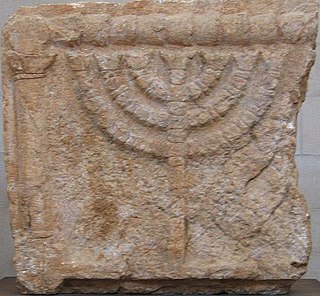
Kfar Baram synagogue, also Kafar Berem synagogue, is the ruins of two ancient Jewish synagogues at the site of Kafr Bir'im, an ancient village depopulated during the 1948 Palestinian exodus. Today, it is located in Northern Israel, 3 kilometers from the Lebanese border.

Korazim Place in Northern, Israel

Korazim is a community settlement in northern Israel. Located on the Korazim plateau to the north of the Sea of Galilee, it falls under the jurisdiction of Mevo'ot HaHermon Regional Council. In 2019 it had a population of 350.

Jesus Trail Hiking and pilgrimage route in Israel

The Jesus Trail is a 65 km (40 mi) hiking and pilgrimage route in the Galilee region of Israel that traces the route Jesus may have walked, connecting many sites from his life and ministry. The main part of the trail begins in Nazareth and passes through Sepphoris, Cana, the Horns of Hattin, Mount Arbel Cliffs, the Sea of Galilee, Capernaum, Tabgha, and the Mount of Beatitudes. An alternate return route passes by Tiberias, the Jordan River, Mount Tabor, and Mount Precipice.

Meiron Place in Safad, Mandatory Palestine

Meiron was a Palestinian village, located 5 kilometers (3.1 mi) west of Safad. Associated with the ancient Canaanite city of Merom, excavations at the site have found extensive remains from the Hellenistic and Early Roman periods. The remains include a 3rd-century synagogue, and Meiron served as a prominent local religious centre at the time.

Khirbat al-Minya

Khirbat al-Minya, also known as Ayn Minyat Hisham (Arabic) or Horvat Minnim (Hebrew) is an Umayyad-built palace in the eastern Galilee, Israel, located about 200 meters (660 ft) west of the northern end of Lake Tiberias. It was erected as a qasr complex, with a palace, mosque, and bath built by a single patron.

Hawsha Place in Haifa, Mandatory Palestine

Hawsha was a Palestinian village located 13 kilometers (8.1 mi) east of Haifa, about 100 meters (330 ft) above sea level. Ruins on the site include ancient mosaics and tombs. The site had a Maqam (shrine) for Nabi Hushan.

Khirbat Umm Burj Place in Hebron, Mandatory Palestine

Khirbat Umm Burj was a Palestinian Arab village in the Hebron Subdistrict, sometimes designated in modern maps as Burgin. It occupied an extensive site, stretching about 30 dunams on the crest of a hill, rising some 430 metres (1,410 ft) above sea level, and commanding a good prospect of the surrounding region. It was depopulated during the 1948 Arab–Israeli War on October 28, 1948 during the third stage of Operation Yo'av under the command of Yigal Allon. The site is located 17 km northwest of Hebron.

Ghuwayr Abu Shusha Place in Tiberias, Mandatory Palestine

Ghuwayr Abu Shusha was a Palestinian Arab village in the Tiberias Subdistrict. It was depopulated during the 1947–1948 Civil War in Mandatory Palestine on April 21, 1948. It was located 8 km north of Tiberias, nearby Wadi Rubadiyya.

Ancient synagogues in Israel

Ancient synagogues in Israel refers to synagogues in the modern State of Israel, built by the Jewish and Samaritan communities from antiquity to the Early Islamic period.

Ancient synagogues in Palestine

Ancient synagogues in Palestine refers to synagogues and their remains in the region commonly referred to as Palestine, built by the Jewish and Samaritan communities from the time of the Hasmonean dynasty during the Late Hellenistic period, to the Late Byzantine period.

Huqoq

Huqoq or Hukkok was an ancient Jewish village, located 12.5 km north of Tiberias. The area had been settled since ancient times and is mentioned in the Book of Joshua. The Arab village Yaquq was built at Huqoq's location, and a kibbutz named Hukok was established near the site on 11 July 1945.

Khirbet Qana

Khirbet Qana, is an archaeological site in the Lower Galilee of Israel. It has remains of a settlement from the Hellenistic to the Early Arab period. It has been associated with the Marriage at Cana of the New Testament.

Khirbet Shema Archaeological site located in Israel at the foot of Mount Meron

Khirbet Shema is an archaeological site located in Israel at the foot of Mount Meron.

References

  1. Jews and Christians in the Holy Land: Palestine in the Fourth Century
  2. Stemberger, 2000, pp.141-142
  3. 1 2 Khalidi, 1992, p. 462
  4. Kh. Umm el-Kalkha
  5. Hachlili, Rachel. Ancient Jewish Art and Archaeology in the Land of Israel
  6. Avraham Negev; Shimon Gibson (July 2005). Archaeological encyclopedia of the Holy Land. Continuum International Publishing Group. p. 118. ISBN   978-0-8264-8571-7 . Retrieved 15 May 2011.
  7. Steven Fine (2005). Art and Judaism in the Greco-Roman world: toward a new Jewish archaeology. Cambridge University Press. ISBN   978-0-521-84491-8 . Retrieved 15 May 2011. p.190
  8. Steven Fine (2005). Art and Judaism in the Greco-Roman world: toward a new Jewish archaeology. Cambridge University Press. ISBN   978-0-521-84491-8 . Retrieved 15 May 2011. p.92
  9. 1 2 "Three Woes". Archived from the original on 2016-03-10. Retrieved 2016-03-10.
  10. Anders Runesson; Donald D. Binder; Birger Olsson (2008). The Ancient Synagogue from its Origins to 200 C.E. . Brill. p.  32. ISBN   978-90-04-16116-0.
  11. Alexander, Paul Julius (1985). The Byzantine Apocalyptic Tradition . pp.  195–196. ISBN   0520049985.
  12. Lightfoot, J., A Commentary on the New Testament From the Talmud and Hebraica: Matthew, accessed 6 January 2017
  13. Smith, Eli (1856). Biblical Researches in Palestine, and in the Adjacent Regions: A Journal of Travels in the Year 1838. Crocker and Brewster. p. 347.

Bibliography