
Bayt Nabala or Beit Nabala was a Palestinian Arab village in the Ramle Subdistrict in Palestine that was destroyed during the 1948 Arab–Israeli War. The village was in the territory allotted to the Arab state under the 1947 UN Partition Plan, which was rejected by Arab leaders and never implemented. Its population in 1945, before the war, was 2,310.

Bayt Dajan, also known as Dajūn, was a Palestinian Arab village situated approximately 6 kilometers (3.7 mi) southeast of Jaffa. It is thought to have been the site of the biblical town of Beth Dagon, mentioned in the Book of Joshua and in ancient Assyrian and Ancient Egyptian texts. In the 10th century CE, it was inhabited mostly by Samaritans.

Kafr 'Ana was a Palestinian town located 11 kilometers (6.8 mi) east of Jaffa, built on the ancient site of Ono. In 1945, the town had an estimated population of 2,800 Arabs and 220 Jews. The village was captured by the Haganah in April during the 1948 Palestine war. A number of Palestinian villagers were killed and the rest fled or were expelled, whereafter the village was destroyed. Today, the old village site lies within the modern Israeli city of Or Yehuda.

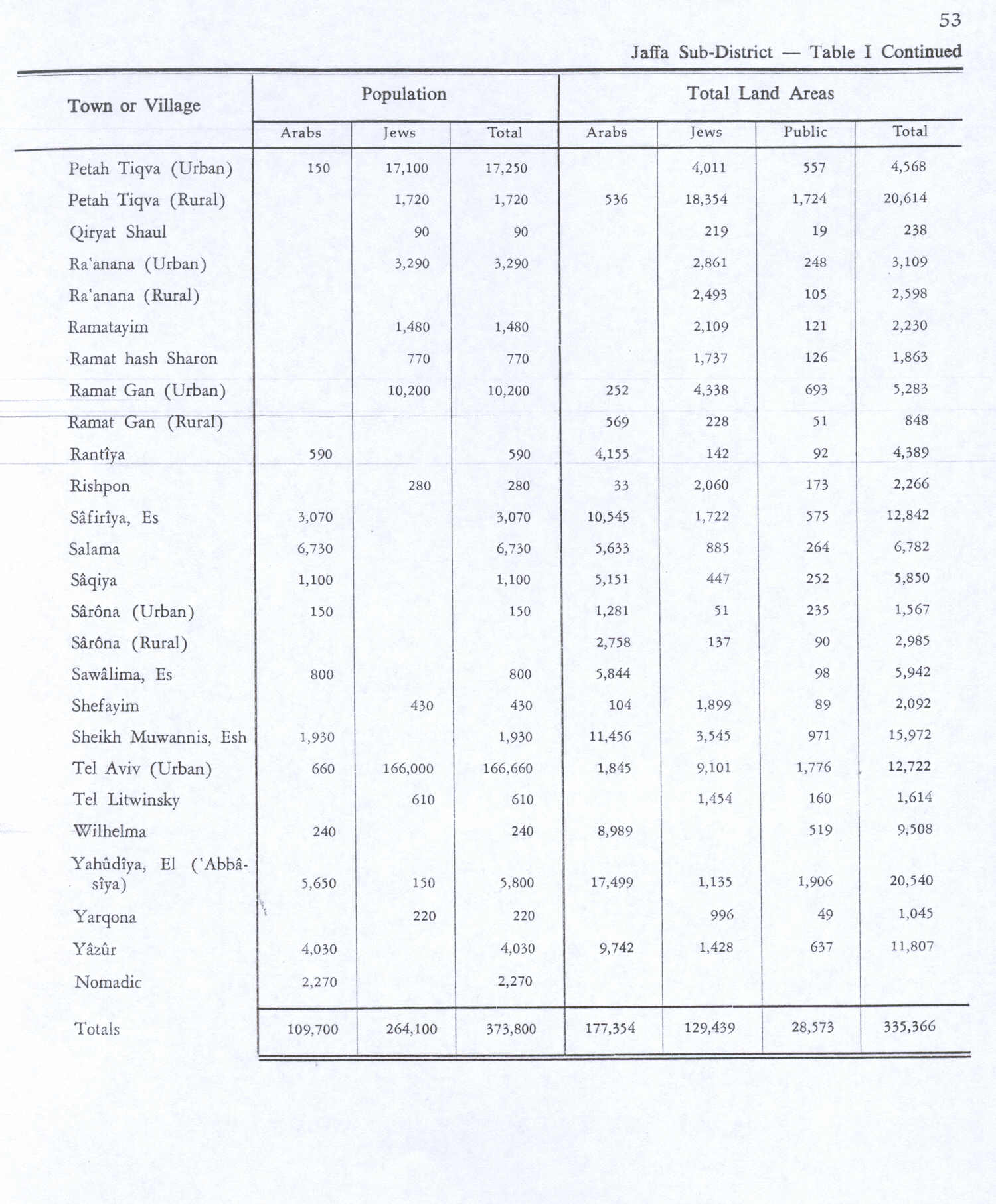
Yazur was a Palestinian Arab town located 6 kilometers (3.7 mi) east of Jaffa. Mentioned in 7th century BCE Assyrian texts, the village was a site of contestation between Muslims and Crusaders in the 12th-13th centuries.

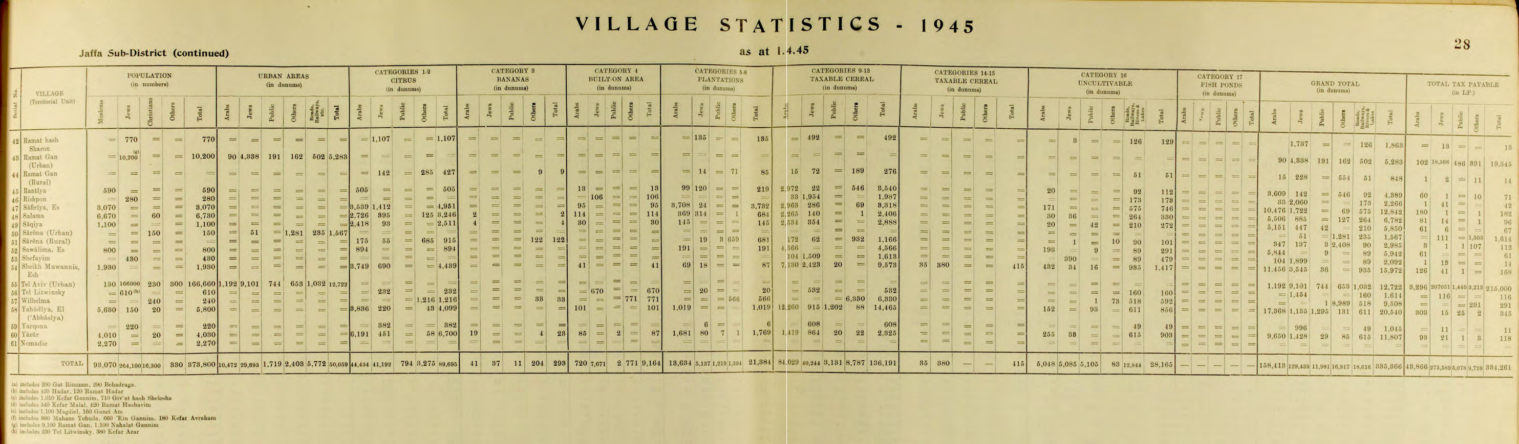
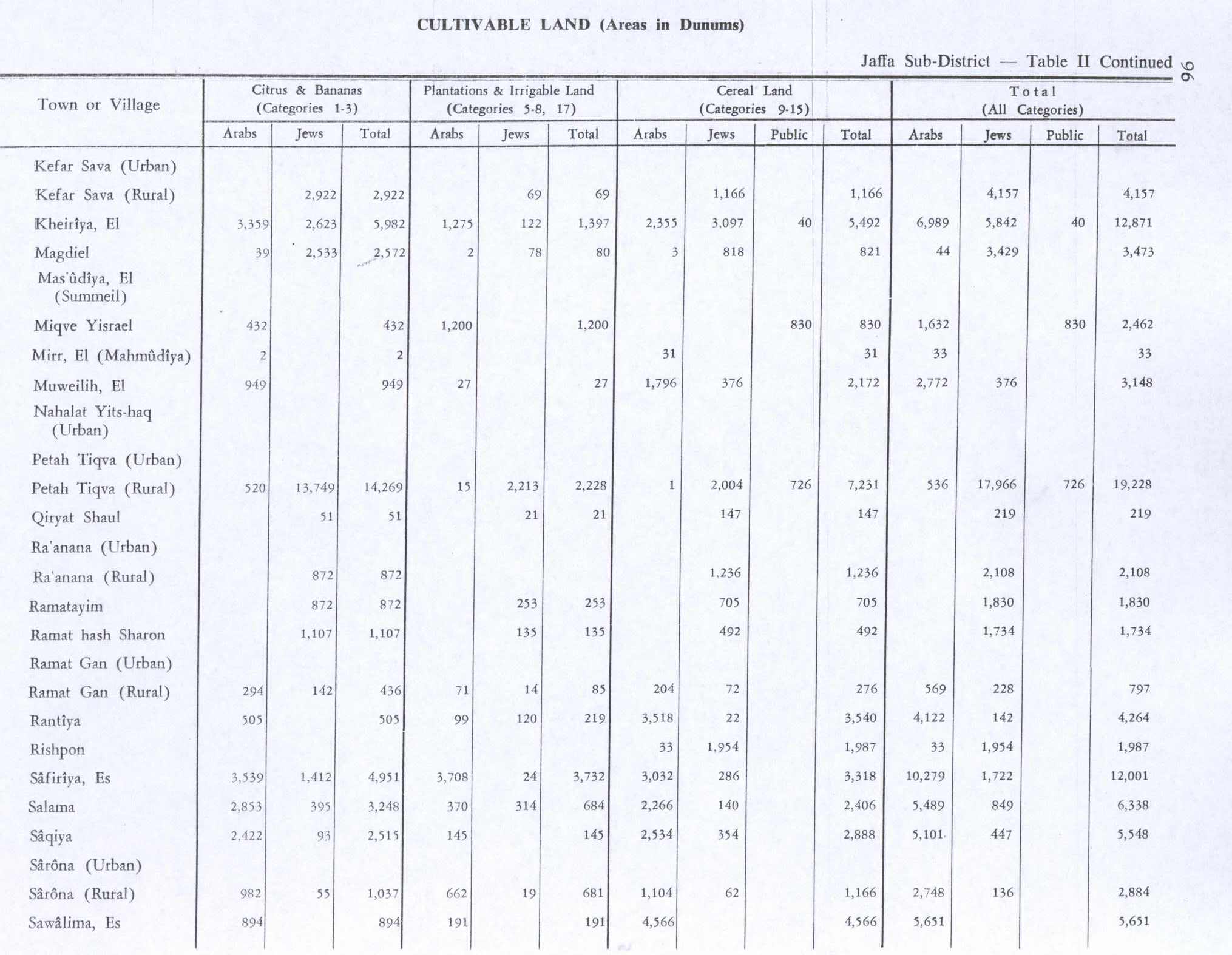
Rantiya was a Palestinian village, located 16 kilometers east of Jaffa. During the British Mandate in Palestine, in 1945 it had a population of 590 inhabitants.

Al-Muzayri'a was a Palestinian village in the Ramle Subdistrict. It was depopulated in 1948. In 1998 the new Israeli city of El'ad was built over the ruins.

Salbit was a Palestinian Arab village located 12 kilometers (7.5 mi) southeast of al-Ramla. Salbit was depopulated during the 1948 Arab–Israeli War after a military assault by Israeli forces. The Israeli locality of Shaalvim was established on the former village's lands in 1951.

Al-Sawalima was a Palestinian Arab village in the Jaffa Subdistrict. It was depopulated during the 1947–1948 Civil War in Mandatory Palestine on March 30, 1948. It was located 11 km northeast of Jaffa, situated 2 km north of the al-'Awja River.

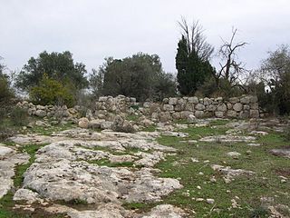
Barfiliya was a Palestinian village located 10.5 kilometres (6.5 mi) east of Ramla that was depopulated during the 1948 Arab–Israeli War. Located on a tell, excavations conducted there by Israeli archaeologists beginning in 1995 found artifacts dating back to the Pre-Pottery Neolithic A (PPNA) period.

Al-Barriyya was a Palestinian village in the Ramle Subdistrict of Mandatory Palestine. It was depopulated during the 1948 Arab–Israeli War on July 10, 1948, as part of Operation Dani. It was located 5.5 km southeast of Ramla, on the eastern bank of Wadi al-Barriyya.
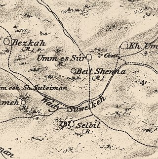
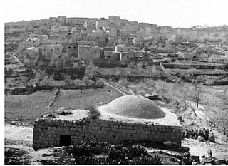
Bayt Shanna was a Palestinian Arab village in the Ramle Subdistrict of Mandatory Palestine. It was depopulated during the 1948 Arab–Israeli War on July 15, 1948, during the second stage of Operation Dani. It was located 11.5 km southeast of Ramla.

Bir Ma'in was a Palestinian Arab village in the Ramle Subdistrict. It was depopulated during the 1948 Arab-Israeli War on July 15, 1948 during the second phase of Operation Danny by the First and Second Battalions of the Yiftach Brigade. It was located 14 km east of Ramla. The village was defended by the Jordanian Army.
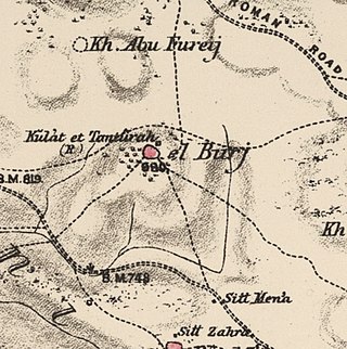
Al-Burj was a Palestinian Arab village 14 km east of Ramle close to the highway to Ramallah, which was depopulated in 1948. Its name, "the tower", is believed to be derived from the crusader castle, Castle Arnold, built on the site. Victorian visitors in the 19th century recorded seeing crusader ruins close to the village.

Daniyal was a Palestinian village in the Ramle Subdistrict that was located 5 km east of Ramla and southeast of Lydda. It was depopulated during the 1948 Arab–Israeli War on July 10, 1948, by the Yiftach Brigade under the first phase of Operation Dani, as part of the broader 1948 Palestinian expulsion and flight and Nakba.

Dayr Tarif was a Palestinian Arab village in the Ramle Subdistrict of Mandatory Palestine. It was depopulated during the 1948 Arab-Israeli War on July 10, 1948.

Al-Haditha was a Palestinian village in the Ramle Subdistrict. It was located 8 km northeast of Ramla, on the bank of Wadi al-Natuf. The site, now known as Tel Hadid, has yielded significant archaeological remains from many periods. Al-Haditha was depopulated during the 1948 Arab-Israeli War on July 12, 1948, under the first stage of Operation Dani.
'Innaba, also spelled 'Annaba, was a Palestinian village in the Ramle Subdistrict of Mandatory Palestine. It was depopulated during the 1948 Arab–Israeli War on July 10, 1948 by the Yiftach and Eighth Brigades of Operation Dani. It was located 7 km east of Ramla.
Kharruba was a Palestinian Arab village in the Ramle Subdistrict of Mandatory Palestine, near Modi'in. It was located 8 km east of Ramla. It was depopulated on July 12, 1948, during the 1948 Arab–Israeli War.

Al-Kunayyisa was a small Palestinian Arab village in the Ramle Subdistrict. It was depopulated during the 1948 Arab–Israeli War on July 10, 1948, under the first stage of Operation Dani. It was located 12 km southeast of Ramla.

Shilta was a Palestinian Arab village in the Ramle Subdistrict of Mandatory Palestine. Sitting on a hill, It was probably settled in the 19th century. It was depopulated during the 1948 Arab–Israeli War on July 18, 1948, by the First Battalion of the Yiftach Brigade in the Operation Danny. It was located 15 km east of Ramla.
 1870s map
  1940s map
 modern map
  1940s with modern overlay map


