Jarisha

Last updated • 2 min readFrom Wikipedia, The Free Encyclopedia
Jarisha
جرِيشة
Jerisha, Jarush
SHb` tKHnvt b 1917.png
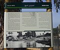
Old mill at Jarisha, about 1917
Etymology: Jerisheh, from "to pound" or "grind" [1]
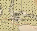
Historical map series for the area of Jarisha (1870s).jpg 1870s map
Historical map series for the area of Jarisha (1940s).jpg 1940s map
Historical map series for the area of Jarisha (modern).jpg modern map
Historical map series for the area of Jarisha (1940s with modern overlay).jpg 1940s with modern overlay map
A series of historical maps of the area around Jarisha (click the buttons)
Mandatory Palestine location map.svg
Red pog.svg
Jarisha
Location within Mandatory Palestine
Coordinates: 32°5′43″N34°48′28″E / 32.09528°N 34.80778°E / 32.09528; 34.80778
Palestine grid 132/167
Geopolitical entity Mandatory Palestine
Subdistrict Jaffa
Area
[2]
  Total555  dunams (55.5 ha or 137 acres)
Population
 (1945)
  Total190 [2] [3]
Current Localities Yarkon Park, Tel Aviv, [4] Ramat Gan

Jarisha (Arabic : جرِيشة, also transliterated Jerisha; Hebrew : ג'רישה) was a Palestinian Arab village located 200 meters (660 ft) from the ancient site of Tell Jarisha (Tel Gerisa), on the south bank of Al-Awja (Yarkon River). [5] [6] After the establishment of Tel Aviv, it was one of five Arab villages to fall within its municipal boundaries. [4] Jarisha was depopulated in the lead up to the 1948 Arab-Israeli war. [6]

Contents

History

Jarisha was located only 200 meters (660 ft) from Tel Gerisa, an archaeological site dating to the Early Bronze II period (2800-2600 BC). In the Middle Bronze period (2000-1500 BC) the site was a fortified Hyksos town. It was succeeded by a Philistine settlement around the 12th century BC. [7]

Ottoman period

In the 1596 tax records under the Ottoman Empire, it was a village in the nahiya ("subdistrict") of the Bani Sa'b, part of Nablus Sanjak. It had a population of 22 Muslim households; an estimated 121 persons, who paid taxes on buffalo, goats and beehives; a total of 2,150 akçe. [8]

In 1856 the village was named Darishah on Kiepert's map of Palestine published that year. [9] An Ottoman village list from about 1870 showed that the village had a population of 76 in a total of 38 houses, though that population count included men, only. It was further noted that it was located 6000 meters NE of Jaffa. [10] [11]

In 1882 the PEF's Survey of Western Palestine (SWP) described the village, transcribed as "Jerisheh", as being built of adobe bricks and flanked by an olive grove. It had a well and a mill. [12] South-east of the village was the ruins of a Khan, a graveyard and some caves, also a masonry dam and a small bridge, "apparently Saracenic". [13]

British Mandate era

In the 1922 census of Palestine conducted by the British Mandate authorities, Jerisheh had a population of 57, all Muslims [14] increasing by the 1931 census to 183, still all Muslims, in a total of 43 houses. [15]

Since May 1944, Jarisha was part of the municipality of Ramat Gan. [16]

In the 1945 statistics it had a population of 190 Muslims, [3] with 555 dunams of land. [2] The villagers worked in the service industry, but some also grew fruits and vegetables; in 1944-45 a total of 302 dunums of village land was used for citrus and bananas, and 89 dunums were irrigated or used for orchards. [17] 3 dunams were classified as built-up areas. [18]

1948, and after

According to the Palestinian historian Walid Khalidi, the state of the village site in 1992 was as follows: "The site has been completely covered over by highways and suburban houses." [19]

See also

Related Research Articles

<span class="mw-page-title-main">Al-Shaykh Muwannis</span> Place in Jaffa, Mandatory Palestine

Al-Shaykh Muwannis, also Sheikh Munis, was a small Palestinian Arab village in the Jaffa Subdistrict of Mandatory Palestine, located approximately 8.5 kilometers from the center of Jaffa city in territory earmarked for Jewish statehood under the UN Partition Plan. The village was abandoned in March 1948 due to the threats of Jewish militias, two months before the 1948 Arab–Israeli war. Today, Tel Aviv University lies on part of the village land.

<span class="mw-page-title-main">Qula</span> Place in Ramle, Mandatory Palestine

Qula was a Palestinian village in the Ramle Subdistrict of Mandatory Palestine, located 15 km northeast of Ramla. Its residents had their origins in Jimzu, Ammuriya and other places.

<span class="mw-page-title-main">Ra'na</span> Place in Hebron, Mandatory Palestine

Ra'na was a village located approximately 26 km northwest of Hebron. It was occupied by the Israeli army during Operation Yo'av in October 1948. It was one of 16 villages in the Hebron district that were depopulated.

<span class="mw-page-title-main">Biyar 'Adas</span> Place in Jaffa, Mandatory Palestine

Biyar 'Adas was a Palestinian Arab village located 19 km northeast of the city of Tel Aviv. In 1945 the village had a population of 300 and a total land area of 5,492 dunums.

<span class="mw-page-title-main">Jimzu</span> Place in Ramle, Mandatory Palestine

Jimzu, also known as Gimzo, was a Palestinian village, located three miles southeast of Lydda. Under the 1947 UN Partition Plan of Mandatory Palestine, Jimzu was to form part of the proposed Arab state. During the 1948 Arab–Israeli War, the village was depopulated in a two-day assault by Israeli forces.

<span class="mw-page-title-main">Fajja</span> Place in Jaffa, Mandatory Palestine

Fajja was a Palestinian town located 15 kilometers northeast of Jaffa. Depopulated and destroyed during the Arab-Israeli war, its land area is today part of the Israeli city of Petah Tikva.

<span class="mw-page-title-main">Qazaza</span> Place in Ramle, Mandatory Palestine

Qazaza was a Palestinian village in the Ramle Subdistrict of Mandatory Palestine, located 19 kilometers (12 mi) south of Ramla. It was depopulated in 1948.

<span class="mw-page-title-main">Saqiya</span> Place in Jaffa, Mandatory Palestine

Saqiya was a village in Palestine 8.5 kilometers (5.3 mi) away from Jaffa, depopulated in 1948.

<span class="mw-page-title-main">Idnibba</span> Place in Ramle, Mandatory Palestine

Idnibba was a Palestinian village, located at latitude 31.7426937N and longitude 34.8561001,E in the southern part of the Ramle Subdistrict. It was depopulated in 1948, at which time its population was 568, and its lands are now used by Kfar Menahem.

<span class="mw-page-title-main">Shahma</span> Village in Ramle, Mandatory Palestine

Shahma was a Palestinian Arab village located 15 kilometers (9.3 mi) southwest of Ramla. Depopulated on the eve of the 1948 Arab-Israeli war, the village lands today form part of a fenced-in area used by the Israeli Air Force.

<span class="mw-page-title-main">Tall al-Shawk</span> Village in Baysan, Mandatory Palestine

Tall al-Shawk, was a Palestinian village in the District of Baysan. It was depopulated by the Israel Defense Forces during the 1947–1948 Civil War in Mandatory Palestine on May 12, 1948, as part of Operation Gideon. It was located five km west of Baysan between the al-Januna'in River to the north and Wadi al-Jawsaq to the south. The village was built above an ancient archeological site and granite columns remain.

<span class="mw-page-title-main">Al-Mas'udiyya</span> Place in Jaffa, Mandatory Palestine

Al-Mas'udiyya, was a Palestinian Arab village in the Jaffa Subdistrict. It was depopulated during the 1947–1948 Civil War in Mandatory Palestine on December 25, 1947. It was located 5 km northeast of Jaffa, situated 1.5 km south of the al-'Awja River. The village used to be known as Summayl.

<span class="mw-page-title-main">Al-Mirr</span> Place in Jaffa, Mandatory Palestine

Al-Mirr, also named Mahmudiyeh, was a Palestinian Arab village in the Jaffa Subdistrict, which was depopulated during the 1947–1948 Civil War in Mandatory Palestine on February 1, 1948.

<span class="mw-page-title-main">Al-Burayj, Jerusalem</span> Place in Jerusalem, Mandatory Palestine

Al-Burayj or Bureij, lit. 'little tower', was a Palestinian Arab village in the Jerusalem Subdistrict. It was depopulated during the 1948 Arab–Israeli War on October 19, 1948, during the first phase of Operation Ha-Har. The village was located 28.5 km west of Jerusalem.

<span class="mw-page-title-main">Al-Barriyya</span> Place in Ramle, Mandatory Palestine

Al-Barriyya was a Palestinian village in the Ramle Subdistrict of Mandatory Palestine. It was depopulated during the 1948 Arab–Israeli War on July 10, 1948, as part of Operation Dani. It was located 5.5 km southeast of Ramla, on the eastern bank of Wadi al-Barriyya.

<span class="mw-page-title-main">Daniyal</span> Village in Ramle, Mandatory Palestine

Daniyal was a Palestinian village in the Ramle Subdistrict. It was depopulated during the 1948 Arab–Israeli War on July 10, 1948, by the Yiftach Brigade under the first phase of Operation Dani. It was located 5 km east of Ramla and southeast of Lydda.

<span class="mw-page-title-main">Al-Maghar</span> Place in Ramle, Mandatory Palestine

Al-Maghar was a Palestinian Arab village in the Ramle Subdistrict of Mandatory Palestine. It was depopulated by the Givati Brigade during Operation Barak on 18 May 1948. It was located 12 km southwest of Ramla, situated north of Wadi al-Maghar.

<span class="mw-page-title-main">Al-Na'ani</span> Place in Ramle, Mandatory Palestine

Al-Na'ani, also called Al-Ni'ana, was a Palestinian Arab village in the Ramle Subdistrict of Mandatory Palestine. It was depopulated during the 1948 Arab–Israeli War on May 14, 1948, by the Givati Brigade during Operation Barak. It was located 6 km south of Ramle.

<span class="mw-page-title-main">Al-Qubayba, Ramle</span> Arab village in Mandatory Palestine

Al-Qubayba was a Palestinian Arab village in the Ramle Subdistrict. It was depopulated during the 1948 Arab-Israeli War on May 27, 1948, by the Givati Brigade as part of the Second stage of Operation Barak. It was located 10.5 km southeast of Ramla near the Rubin River which provided the village with water and irrigation for agriculture. Al-Qubayba was mostly destroyed with the exception of a few houses, and Kfar Gevirol was built in its place, now a suburb in the west of Rehovot.

<span class="mw-page-title-main">Saydun</span> Village in Ramle, Mandatory Palestine

Saydun was a Palestinian village in the Ramle Subdistrict of Mandatory Palestine. It was depopulated during the 1947–48 Civil War in Mandatory Palestine on April 6, 1948, during Operation Nachshon. It was located 9 km south of Ramla on the east bank of Wadi Saydun.

References

  1. Palmer, 1881, p. 215
  2. 1 2 3 Government of Palestine, Department of Statistics. Village Statistics, April, 1945. Quoted in Hadawi, 1970, p. 52
  3. 1 2 Department of Statistics, 1945, p. 27
  4. 1 2 Mann, 2006, p. 246.
  5. Ben-Tor and Greenberg, 1992, p. 246.
  6. 1 2 Khalidi and Elmusa, 1992, p. 246.
  7. Khalidi, 1992, p. 246
  8. Hütteroth and Abdulfattah, 1977, p. 139; cited in Khalidi, 1992, p. 246
  9. Kiepert, 1856, Map of Southern Palestine
  10. Deschelscheh, in Socin, 1879, p. 152
  11. Hartmann, 1883, p. 137, also noted 38 houses at el−dscherische
  12. Conder and Kitchener, 1882, SWP II, p. 251. Quoted in Khalidi, 1992, p.246
  13. Conder and Kitchener, 1882, SWP II, p. 265
  14. Barron, 1923, Table VII, Sub-district of Jaffa, p. 20
  15. Mills, 1932, p. 14
  16. "⁨במושבות ⁩ | ⁨הארץ⁩ | 14 מאי 1944 | אוסף העיתונות | הספרייה הלאומית".
  17. Government of Palestine, Department of Statistics. Village Statistics, April, 1945. Quoted in Hadawi, 1970, p. 95 Also in Khalidi, 1992, p.246-247
  18. Government of Palestine, Department of Statistics. Village Statistics, April, 1945. Quoted in Hadawi, 1970, p. 145
  19. Khalidi, 1992, p. 247

Bibliography