
Qula was a Palestinian village in the Ramle Subdistrict of Mandatory Palestine, located 15 km northeast of Ramla. Its residents had their origins in Jimzu, Ammuriya and other places.

Sar'a, was a Palestinian Arab village located 25 km west of Jerusalem, depopulated in the 1948 war. The site lies on a hill, at an elevation of about 1,150 feet (350 m) above sea-level.

Biyar 'Adas was a Palestinian Arab village located 19 km northeast of the city of Tel Aviv. In 1945 the village had a population of 300 and a total land area of 5,492 dunums.

Jimzu, also known as Gimzo, was a Palestinian village, located three miles southeast of Lydda. Under the 1947 UN Partition Plan of Mandatory Palestine, Jimzu was to form part of the proposed Arab state. During the 1948 Arab–Israeli War, the village was depopulated in a two-day assault by Israeli forces.

Shahma was a Palestinian Arab village located 15 kilometers (9.3 mi) southwest of Ramla. Depopulated on the eve of the 1948 Arab-Israeli war, the village lands today form part of a fenced-in area used by the Israeli Air Force.

Al-Samiriyya, was a Palestinian Arab village in the District of Baysan. It was depopulated by the Israel Defense Forces during the 1948 Arab-Israeli War on May 27, 1948, as part of Operation Gideon. It was located 7 km southeast of Baysan.
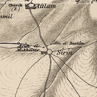
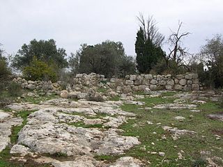
Sirin, was a Palestinian Arab village located 17 kilometers (11 mi) north of Beisan. The village was depopulated and destroyed in 1948. Only the village cemetery and one house remain standing, along with the remains of a mosaic pavement and a vaulted spring dating to the Byzantine period. Mentioned in historical documents, the 1596 census indicated it had 45 households; by 1945, the number of inhabitants had risen to 810.

Dayr Nakhkhas was an Arab village located 20 km northwest of Hebron, overlooking Wadi Bayt Jibrin to the north.

Al-'Abbasiyya, also known as al-Yahudiya, was a Palestinian Arab village in the Jaffa Subdistrict. It was attacked under Operation Hametz during the 1948 Palestine War, and finally depopulated under Operation Dani. It was located 13 km east of Jaffa. Some of the remains of the village can be found today in the centre of the modern Israeli city of Yehud.

Bayt Umm al-Mays was a small Palestinian Arab village in the Jerusalem Sub-district, located 14 km west of Jerusalem..

Barfiliya was a Palestinian village located 10.5 kilometres (6.5 mi) east of Ramla that was depopulated during the 1948 Arab–Israeli War. Located on a tell, excavations conducted there by Israeli archaeologists beginning in 1995 found artifacts dating back to the Pre-Pottery Neolithic A (PPNA) period.

Al-Barriyya was a Palestinian village in the Ramle Subdistrict of Mandatory Palestine. It was depopulated during the 1948 Arab–Israeli War on July 10, 1948, as part of Operation Dani. It was located 5.5 km southeast of Ramla, on the eastern bank of Wadi al-Barriyya.

Bir Ma'in was a Palestinian Arab village in the Ramle Subdistrict. It was depopulated during the 1948 Arab-Israeli War on July 15, 1948 during the second phase of Operation Danny by the First and Second Battalions of the Yiftach Brigade. It was located 14 km east of Ramla. The village was defended by the Jordanian Army.

Dayr Tarif was a Palestinian Arab village in the Ramle Subdistrict of Mandatory Palestine. It was depopulated during the 1948 Arab-Israeli War on July 10, 1948.

Khirbat al-Duhayriyya was a Palestinian Arab village in the Ramle Subdistrict. It was depopulated during the 1948 Arab-Israeli War on July 10, 1948, by the Givati Brigade under the first phase of Operation Dani. It was located 6 km northeast of Ramla.

Al-Haditha was a Palestinian village in the Ramle Subdistrict. It was located 8 km northeast of Ramla, on the bank of Wadi al-Natuf. The site, now known as Tel Hadid, has yielded significant archaeological remains from many periods. Al-Haditha was depopulated during the 1948 Arab-Israeli War on July 12, 1948, under the first stage of Operation Dani.
Kharruba was a Palestinian Arab village in the Ramle Subdistrict of Mandatory Palestine, near Modi'in. It was located 8 km east of Ramla. It was depopulated on July 12, 1948, during the 1948 Arab–Israeli War.

Al-Maghar was a Palestinian Arab village in the Ramle Subdistrict of Mandatory Palestine. It was depopulated by the Givati Brigade during Operation Barak on 18 May 1948. It was located 12 km southwest of Ramla, situated north of Wadi al-Maghar.

Arab al-Shamalina also known as Khirbat Abu Zayna was a Palestinian Arab village in the Safad Subdistrict. It was depopulated during the 1947–1948 Civil War in Mandatory Palestine on May 4, 1948, under Operation Matate (Broom), a sub operation of Operation Yiftach. It was located 13 km southeast of Safad near the Jordan River.

Harrawi was a Palestinian Arab village in the Safad Subdistrict. It was depopulated during the 1948 Arab-Israeli War on May 25, 1948, by the Palmach's First Battalion of Operation Yiftach. It was located 18 km northeast of Safad.

 1870s map
  1940s map
 modern map
  1940s with modern overlay map


