Al-Muharraqa

Last updated

Contents

al-Muharraqa
المحرّقة
al-Muharrqah
Etymology: Kh. Muntaret el Baghl: "the ruin of the watch tower of the mule" [1]
Historical map series for the area of al-Muharraqa (1870s).jpg 1870s map
Historical map series for the area of al-Muharraqa (1940s).jpg 1940s map
Historical map series for the area of al-Muharraqa (modern).jpg modern map
Historical map series for the area of al-Muharraqa (1940s with modern overlay).jpg 1940s with modern overlay map
A series of historical maps of the area around Al-Muharraqa (click the buttons)
Mandatory Palestine location map.svg
Red pog.svg
al-Muharraqa
Location within Mandatory Palestine
Coordinates: 31°28′01″N34°36′41″E / 31.46694°N 34.61139°E / 31.46694; 34.61139
Palestine grid 113/097
Geopolitical entity Mandatory Palestine
Subdistrict Gaza
Date of depopulationMay 25, 1948 [2]
Area
[3]
  Total
4,855  dunams (4.855 km2 or 1.875 sq mi)
Population
 (1945)
  Total
580 [4] [3]
Cause(s) of depopulationMilitary assault by Yishuv forces
Current Localities Yakhini [5]

Al-Muharraqa (Arabic : المحرّقة) was a Palestinian Arab village in the Gaza Subdistrict, located 14.5 kilometers (9.0 mi) east of Gaza city. The village laid on rolling terrain on the southern coastal plain of Palestine, on a bend in the wadi . It had an elevation of 125 meters (410 ft) and a total land area of 4,855 dunams, most of which was public property, while its built-up area of 29 dunams was Arab-owned. Al-Muharraqa was depopulated during the 1948 Arab-Israeli War. [5]

History

Although not mentioned in Byzantine sources, al-Muharraqa was inhabited during this period, according to archaeological evidence. [5] Byzantine ceramics, together with fragments of marble columns and a fragmentary mosaic pavement with geometric patterns have been found. [6]

During the Mamluk period from the 13th to 15th centuries, the lands and surplus agricultural produce of al-Muharraqa were dedicated as a waqf for the maintenance of the Dome of the Rock in Jerusalem and the Great Mosque of Gaza. [5]

Ottoman era

It was incorporated into the Ottoman Empire in 1517, and in a sijill (royal order) from 941/1535 all of the revenue from Al-Muharraqa went to Ribat al-Mansuri (Com.); a hospital in Jerusalem started by Al-Mansur Qalawun in 1282. [7] In the 1596 tax records, it was under the administration of the nahiya of Gaza, part of the Sanjak of Gaza, with a population of 83 Muslim households, an estimated 457 persons. The villagers paid a fixed tax rate of 25% on a number of crops, including wheat, barley, beehives, and goats; a total of 26,600 akçe. All of the revenue went to a Waqf. [8]

Al-Muharraqa was likely abandoned in either the 17th or 18th century, since it lacked mention by travellers, but was repopulated in the late 1870s. [5]

In 1838 Edward Robinson noted it as el Muhurrakah, in the Gaza district, being "in ruins or deserted". [9]

In 1883 the PEF's Survey of Western Palestine found of archaeological remains at the place, called Khürbet Muntaret el Baghl, "a few scattered stones and ruined rubble cisterns on a slope." [10]

British mandate era

During the British Mandate period, the overall layout of the village was rectangular, and continued to expand in a rectangular pattern along the roads leading to the highway and the village of Kawfakha. [5] In the 1922 census of Palestine, Muharraqa had a population of 204 Muslims, [11] increasing in the 1931 census when Muharraqa had a population of 354 Muslims in 86 houses. [12]

al-Muharraqa 1931 1:250,000 Al-Muharraqa 1931.jpg
al-Muharraqa 1931 1:250,000
al-Muharraqa 1945 1:250,000 Kaufakha 1945.jpg
al-Muharraqa 1945 1:250,000

In the 1945 statistics Al-Muharraqa had a population of 580 Muslims, [4] with a total of 4,855 dunams of land, according to an official land and population survey. [3] Of this, 12 dunams were used for plantations and irrigable land, 4,622 for cereals, [13] while 39 dunams were public built-up land. [14]

The houses of the village were constructed of mud bricks, and there was a mosque and a school; the latter opened in 1945 with an enrollment of 60 students. The mosque, school, and a number of small shops constituted al-Muharraqa's nucleus. Water for household use was primarily obtained from a slightly salty 90 meters (300 ft) well, but was supplemented with rainwater which collected in some shallow domestic wells. Agriculture was the main source of income, especially the village's chief crop, barley. Figs, grapes, and almonds were also cultivated. [5]

1948 War, and aftermath

During the 1948 Arab-Israeli War, the village with Kawfakha was raided by the Palmach's Negev Brigade on May 27–28, and a correspondent for The New York Times reported it was officially captured on May 29. [15] Israeli historian Benny Morris claims most of al-Muharraqa's inhabitants were driven out at that time, but it was not thoroughly destroyed and depopulated until August 16; Israeli forces were officially observing the second truce, however, Morris writes that they proceeded to mine and destroy the village for "military reasons". [5]

Following the war the area was incorporated into the State of Israel and the moshav of Yakhini was built north of the village site in 1950 on village land. [5] T'kuma, established in 1949, although the latter was built on lands belonging to the city of Gaza, but just 2 kilometers (1.2 mi) west of al-Muharraqa's village site. [5]

Palestinian historian Walid Khalidi described the village remains in 1992:

The site is overgrown with thorny plants and short grasses and surrounded by eucalyptus trees. It is marked by piles of rubble from buildings, including the village diwan (a meeting and guest house). There are also the remnants of a mill and a well. The cemetery, overgrown with wild vegetation, still exists, in a dilapidated condition, and the fallen superstructure of one of the tombs is visible. The lands in the vicinity are cultivated by farmers. [5]

See also

Related Research Articles

<span class="mw-page-title-main">Al-Mansura, Acre</span> Village in Acre, Mandatory Palestine

Al-Mansura, was a Palestinian village that was depopulated by the Israeli army during the 1948 Arab-Israeli war. In 1945, it had a population of 2,300 together with the neighboring villages of Dayr al-Qassi and Fassuta. The population was predominantly Christian and most its residents live in what is now the state of Israel.

<span class="mw-page-title-main">Kawfakha</span> Place in Gaza, Mandatory Palestine

Kawfakha' was a Palestinian village located 18 kilometers (11 mi) east of Gaza that was depopulated during the 1948 Arab-Israeli war.

<span class="mw-page-title-main">Bayt Jirja</span> Place in Gaza, Mandatory Palestine

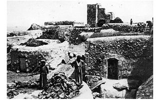
Bayt Jirja or Beit Jerja was a Palestinian Arab village 15.5 km Northeast of Gaza. In 1931 the village consisted of 115 houses. It was overrun by Israeli forces during operation Yo'av in the 1948 Arab-Israeli war. Bayt Jirja was found depopulated in November 1948, during "clean up sweeps" to expel any partial inhabited villages and destroy village housing to prevent any possible re-occupation in the area. The village was completely destroyed after the occupation and only one tomb remains.

<span class="mw-page-title-main">Barqa, Gaza</span> Place in Gaza, Mandatory Palestine

Barqa was a Palestinian Arab village located 37 km north of Gaza near the modern-day Israeli city of Ashdod. It was referred to as Barka by the Greeks and Bareca by the Romans during their rule over the ancient Philistine city. In 1945, the village had a population of 890 and total land area of 5,206 dunums.

<span class="mw-page-title-main">Simsim, Gaza</span> Place in Gaza, Mandatory Palestine

Simsim, also spelled Semsem or Sumsum, was a Palestinian village, located 15 kilometers (9.3 mi) northeast of Gaza. It was depopulated and destroyed during the 1948 Palestine war as part of the 1948 Palestinian expulsion and the Nakba.

<span class="mw-page-title-main">Indur</span> Village in Nazareth, Mandatory Palestine

Indur was a Palestinian village, located 10.5 kilometres (6.5 mi) southeast of Nazareth. Its name preserves that of ancient Endor, a Canaanite city state thought to have been located 1 kilometre (0.62 mi) to the northeast. The village was depopulated during the 1948 Arab–Israeli War and its inhabitants became refugees, some of whom were internally displaced. In Israel today, there are a few thousand internally displaced Palestinians who hail from Indur, and continue to demand their right of return.

<span class="mw-page-title-main">Najd, Gaza</span> Place in Gaza, Mandatory Palestine

Najd was a Palestinian Arab village, located 14 kilometers (8.7 mi) northeast of Gaza City. During the British Mandate in Palestine, children from Najd attended school in the nearby village of Simsim. On 13 May 1948, Najd was occupied by the Negev Brigade as part of Operation Barak, and the villagers were expelled.

<span class="mw-page-title-main">Dayr Sunayd</span> Place in Gaza, Mandatory Palestine

Dayr Sunayd was a Palestinian Arab village in the Gaza Subdistrict, located 12 kilometers (7.5 mi) northeast of Gaza. Situated at an elevation of 50 meters (160 ft) along the southern coastal plain of Palestine, Deir Sunayd had a total land area of 6,081 dunams. Prior to its depopulation during the 1948 Arab–Israeli War, it had 730 inhabitants in 1945.

<span class="mw-page-title-main">Al-Sawafir al-Shamaliyya</span> Place in Gaza, Mandatory Palestine

Al-Sawafir al-Shamaliyya was a Palestinian Arab village in the Gaza Subdistrict, located 33 kilometers (21 mi) northeast of Gaza situated along the southern coastal plain of Palestine 50 meters (160 ft) above sea level. It was one of three namesake villages, alongside Al-Sawafir al-Sharqiyya and Al-Sawafir al-Gharbiyya.

<span class="mw-page-title-main">Arab al-Bawati</span> Village in Baysan, Mandatory Palestine

Arab al-Bawati, was a Palestinian Arab village in the District of Baysan. It was depopulated during the 1948 Arab-Israeli War.

<span class="mw-page-title-main">Bil'in, Gaza</span> Village in Gaza, Mandatory Palestine

Bil'in was a Palestinian Arab village in the Gaza Subdistrict. It was depopulated by the Israel Defense Forces during the 1948 Arab–Israeli War on July 8, 1948, under Operation An-Far. It was located 39 km northeast of Gaza and the village contained two wells which supplied it with drinking water.

<span class="mw-page-title-main">Hulayqat</span> Village in Gaza, Mandatory Palestine

Hulayqat was a Palestinian Arab village in the Gaza Subdistrict. It was depopulated during the 1947–1948 Civil War in Mandatory Palestine. It was located 20.5 km northeast of Gaza.

<span class="mw-page-title-main">Jusayr</span> Place in Gaza, Mandatory Palestine

Jusayr was a Palestinian Arab village in the Gaza Subdistrict. It was depopulated during the 1948 Arab-Israeli War on July 17, 1948, under Operation Barak or Operation Yo'av. It was located 35 km northeast of Gaza.

<span class="mw-page-title-main">Mughallis</span> Village in Hebron, Mandatory Palestine

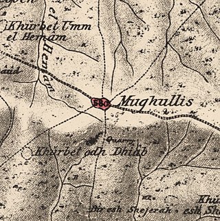
Mughallis was a Palestinian Arab village located 30.5 kilometers (19.0 mi) northwest of Hebron. It was depopulated during the 1948 Arab-Israeli War between July 9–10, 1948 as part of Operation An-Far.

<span class="mw-page-title-main">Bayt Shanna</span> Place in Ramle, Mandatory Palestine

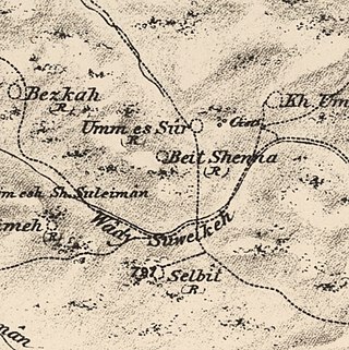
Bayt Shanna was a Palestinian Arab village in the Ramle Subdistrict of Mandatory Palestine. It was depopulated during the 1948 Arab–Israeli War on July 15, 1948, during the second stage of Operation Dani. It was located 11.5 km southeast of Ramla.

<span class="mw-page-title-main">Bir Ma'in</span> Place in Ramle, Mandatory Palestine

Bir Ma'in was a Palestinian Arab village in the Ramle Subdistrict. It was depopulated during the 1948 Arab-Israeli War on July 15, 1948 during the second phase of Operation Danny by the First and Second Battalions of the Yiftach Brigade. It was located 14 km east of Ramla. The village was defended by the Jordanian Army.

<span class="mw-page-title-main">Al-Kunayyisa</span> Place in Ramle, Mandatory Palestine

Al-Kunayyisa was a small Palestinian Arab village in the Ramle Subdistrict. It was depopulated during the 1948 Arab–Israeli War on July 10, 1948, under the first stage of Operation Dani. It was located 12 km southeast of Ramla.

<span class="mw-page-title-main">Al-Tina</span> Place in Ramle, Mandatory Palestine

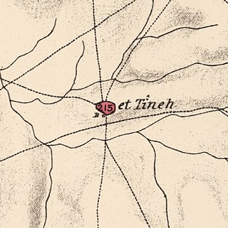
Al-Tina, or Khirbet et-Tineh was a Palestinian Arab village in the Ramle Subdistrict of Mandatory Palestine. The village was located between the Shfela and southern Israeli coastal plain. It was depopulated during the 1948 Arab–Israeli War on July 8, 1948, by the Givati Brigade under Operation An-Far. It was located 20. km south of Ramla. The hill on which the village was built stands today next to the Kiryat Mal'akhi – Yoav railway station and next to Highway 6. Archeological excavations at the site revealed the remains of a Byzantine settlement.

<span class="mw-page-title-main">Fara, Safad</span> Village in Safad, Mandatory Palestine

Fara was a Palestinian Arab village in the Safad Subdistrict. It was depopulated during the 1948 Arab-Israeli War on October 30, 1948, under Operation Hiram. It was located 11.5 km north of Safad on the Wadi al-Fara.

<span class="mw-page-title-main">Al-Qudayriyya</span> Village in Safad, Mandatory Palestine

Al-Qudayriyya was a Palestinian Arab village in the Safad Subdistrict. It was depopulated during the 1947–1948 Civil War in Mandatory Palestine on May 4, 1948, by the Haganah and the Palmach's First Battalion of Operation Matate, a sub-operation of Operation Yiftach. It was located 6.5 km south of Safad, situated 1 km east of Wadi al-'Amud.
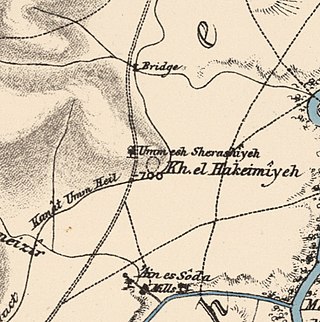
References

  1. Palmer, 1881, p. 373
  2. Morris, 2004, p. xx, village #367. Also gives cause of depopulation
  3. 1 2 3 Government of Palestine, Department of Statistics. Village Statistics, April, 1945. Quoted in Hadawi, 1970, p. 46
  4. 1 2 Government of Palestine, Department of Statistics, 1945, p. 32
  5. 1 2 3 4 5 6 7 8 9 10 11 Khalidi, 1992, p. 127
  6. Dauphin, 1998, p. 955
  7. Burgoyne, 1987, p. 131
  8. Hütteroth and Abdulfattah, 1977, p. 151, as cited in Khalidi, 1992, p.127
  9. Robinson and Smith, 1841, vol 3, Appendix 2, p. 117 (note that * behind the name indicate ruin/desterted)
  10. Conder and Kitchener, 1883, SWP III, p. 284
  11. Barron, 1923, Table V, Sub-district of Gaza, p. 8
  12. Mills, 1932, p. 5
  13. Government of Palestine, Department of Statistics. Village Statistics, April, 1945. Quoted in Hadawi, 1970, p. 87
  14. Government of Palestine, Department of Statistics. Village Statistics, April, 1945. Quoted in Hadawi, 1970, p. 137
  15. Morris, 2004, p. 258

Bibliography