
Al-Mansura, was a Palestinian village that was depopulated by the Israeli army during the 1948 Arab-Israeli war. In 1945, it had a population of 2,300 together with the neighboring villages of Dayr al-Qassi and Fassuta. The population was predominantly Christian and most its residents live in what is now the state of Israel.

Dayr al-Qassi or Deir el-Qasi, was a Palestinian Arab village located 26 km northeast of the city of Acre, which was depopulated during 1948 Arab-Israeli war.

Khirbat Iribbin or Khurbet 'Arubbin, was a Palestinian Arab village in the Upper Galilee, located 23 km (14 mi) northeast of the city of Acre. In 1945, it had a built-up land area of over 2,000 dunums and a population of 360 Arab Muslims.

Tarbikha, was a Palestinian Arab village. It was located 27 kilometres northeast of Acre in the British Mandate District of Acre that was captured and depopulated by the Israel Defense Forces during the 1948 Arab-Israeli war. The inhabitants of this village were, similar to the inhabitants of Southern Lebanon, Shia Muslims.
Safsaf was a Palestinian village 9 kilometres northwest of Safed, present-day Israel. Its villagers fled to Lebanon after the Safsaf massacre in October 1948, during the 1948 Arab–Israeli War.

Kedesh was an ancient Canaanite and later Israelite settlement in Upper Galilee, mentioned several times in the Hebrew Bible. Its remains are located in Tel Kedesh, 3 km northeast of the modern Kibbutz Malkiya in Israel on the Israeli-Lebanese border.

Ammuqa was a Palestinian village, located five kilometres northeast of Safed.

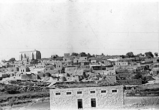
Al-Shajara was a Palestinian Arab village depopulated by Israel during the 1948 Arab-Israeli War when its residents were forcefully evacuated and became refugees. It was located 14 kilometers west of Tiberias on the main highway to Nazareth near the villages of Lubya and Hittin. The village was very close to the city of Nazareth, about 5 kilometers away.

Qaddita was a Palestinian Arab village of 240, located 4.5 kilometers (2.8 mi) northwest of Safad. It was captured and depopulated in the 1948 Arab-Israeli War, with some of its inhabitants expelled or fleeing to nearby 'Akbara where they live as internally displaced Palestinians and others to refugee camps in Lebanon or Syria.

Abil al-Qamh was a Palestinian village located near the Lebanese border north of Safad. It was depopulated in 1948. It was located at the site of the biblical city of Abel-beth-maachah.

Al-Batani al-Sharqi was a Palestinian Arab village in the Gaza Subdistrict, located 36.5 kilometers (22.7 mi) northeast of Gaza situated in the flat terrain on the southern coastal plain of Palestine. It had a population of 650 in 1945. Al-Batani al-Sharqi was depopulated during the 1948 Arab-Israeli War.

Al-Ja'una or Ja'ouna, was a Palestinian village situated in Galilee near al-Houleh Plateau, overlooking the Jordan Valley. The village lay on a hillside 450–500 meters above sea level, 5 kilometers east of Safad near a major road connecting Safad with Tabariya. The village had its Arab residents expelled by Zionist forces in 1948 and was thereafter resettled by Jews, becoming a part of the Israeli settlement of Rosh Pinna.

Dayr Nakhkhas was an Arab village located 20 km northwest of Hebron, overlooking Wadi Bayt Jibrin to the north.
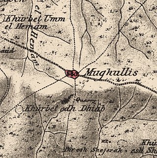
Mughallis was a Palestinian Arab village located 30.5 kilometers (19.0 mi) northwest of Hebron. It was depopulated during the 1948 Arab-Israeli War between July 9–10, 1948 as part of Operation An-Far.

Dayr Tarif was a Palestinian Arab village in the Ramle Subdistrict of Mandatory Palestine. It was depopulated during the 1948 Arab-Israeli War on July 10, 1948.

Qabba'a was a Palestinian Arab village in the District of Safad. It was depopulated during the 1948 War on May 26, 1948, by the Palmach's First Battalion of Operation Yiftach. It was located 6 km northeast of Safad.
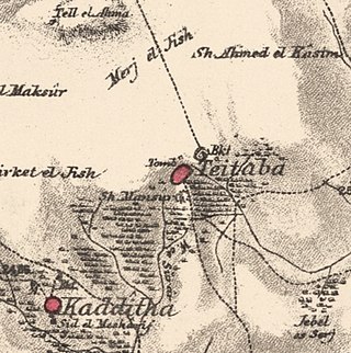
Taytaba was a Palestinian-Arab village in the Safad Subdistrict, located 5 kilometers north of Safad. It was depopulated during the 1947–1948 Civil War in Mandatory Palestine in May 1948 under Operation Hiram. In 1945 it had a population of 530 and a total area of 8,453 dunams, 99.8% of which was Arab-owned.

Al-'Ulmaniyya was a Palestinian Arab village in the Safad Subdistrict. It was depopulated during the 1947–1948 Civil War in Mandatory Palestine on April 20, 1948, by the Palmach's First Battalion of Operation Yiftach. It was located 14.5 km northeast of Safad.

Hadatha, also El Hadetheh or Hadateh, was a Palestinian Arab village in the District of Tiberias, located 12.5 km southwest of Tiberias. It was depopulated in the 1947–1948 civil war in Mandatory Palestine.

Yaquq was a Palestinian Arab village, which was depopulated during the 1947–1948 Civil War in Mandatory Palestine on May 1, 1948. It was located 12.5 km north of Tiberias and was built at the site of the ancient Jewish village of Huqoq.

 1870s map
  1940s map
 modern map
  1940s with modern overlay map

