Nimrin

Last updated
Nimrin

نمرين
Etymology: well-watered [1]
Historical map series for the area of Nimrin (1870s).jpg 1870s map
Historical map series for the area of Nimrin (1940s).jpg 1940s map
Historical map series for the area of Nimrin (modern).jpg modern map
Historical map series for the area of Nimrin (1940s with modern overlay).jpg 1940s with modern overlay map
A series of historical maps of the area around Nimrin (click the buttons)
Mandatory Palestine location map.svg
Red pog.svg
Nimrin
Location within Mandatory Palestine
Coordinates: 32°48′15″N35°25′24″E / 32.80417°N 35.42333°E / 32.80417; 35.42333 Coordinates: 32°48′15″N35°25′24″E / 32.80417°N 35.42333°E / 32.80417; 35.42333
Palestine grid 190/245
Geopolitical entity Mandatory Palestine
Subdistrict Tiberias
Date of depopulation16-17 July 1948 [2]
Area
[3]
  Total12,019  dunams (12.019 km2 or 4.641 sq mi)
Population
 (1945)
  Total320 [4] [3]
Cause(s) of depopulationFear of being caught up in the fighting
Secondary causeMilitary assault by Yishuv forces
Current LocalitiesAchuzzat Naftali, IDF ammunition depot

Nimrin was a Palestinian Arab town of 320 that was captured and depopulated by Israel during the 1948 Arab-Israeli War.

Contents

History

Nimrin stood on the site of Kfar Nimra when Palestine was ruled by the Roman Empire. [5] Its inhabitants were Jews when Saint Peter and Saint James visited the town in 30 CE. [6]

Ottoman era

Nimrin was incorporated into the Ottoman Empire in the early sixteenth century CE, and by the 1596 tax records the village was under the administration of the nahiya ("subdistrict") of Tiberias, part of Safad Sanjak. It had a population of 20 households, an estimated 110 persons, all Muslim. The villagers paid a fixed tax rate of 25% on agricultural products, such as on wheat barley, wheat, olives, beehives, and goats; a total of 3,920 akçe. 1/3 of the revenue went to a waqf. [7] [8]

A map from Napoleon's invasion of 1799 by Pierre Jacotin showed the place, named as Nemen. [9]

In the nineteenth century, Nimrin grew to become a stone-built village of 250 Muslim people. It was described as being built on the slope of a hill, surrounded by arable land. [10] The Ottomans founded an elementary school in the village. [5]

A population list from about 1887 showed Nimrin to have about 300 inhabitants; all Muslims. [11]

British Mandate era

In 1922, Nimrin became a part of the British Mandate of Palestine and in the 1922 census of Palestine, Nemrin had a population of 273; all Muslims, [12] increasing in the 1931 census to 316, still all Muslims, in a total of 71 houses. [13]

The main economic sectors were farming and livestock, with grain being the most important crop, followed by vegetables. The Ottoman school was closed down during this period. [5]

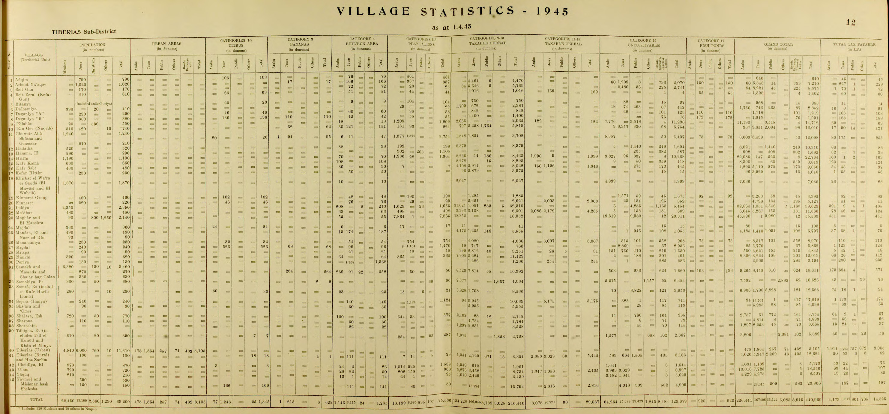
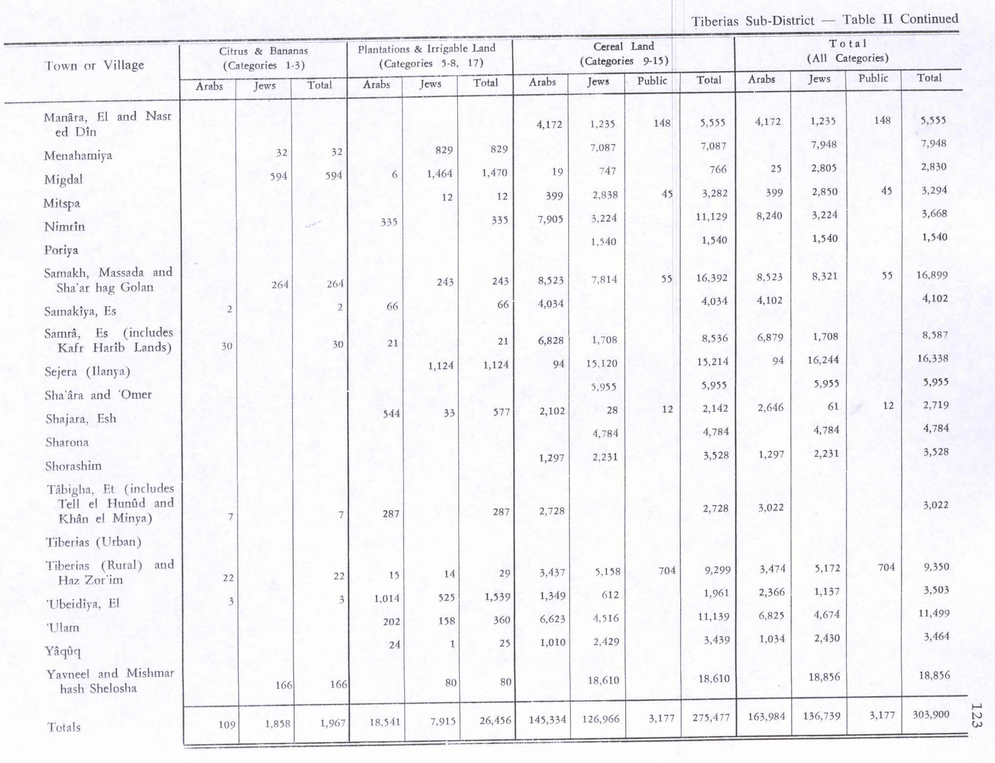
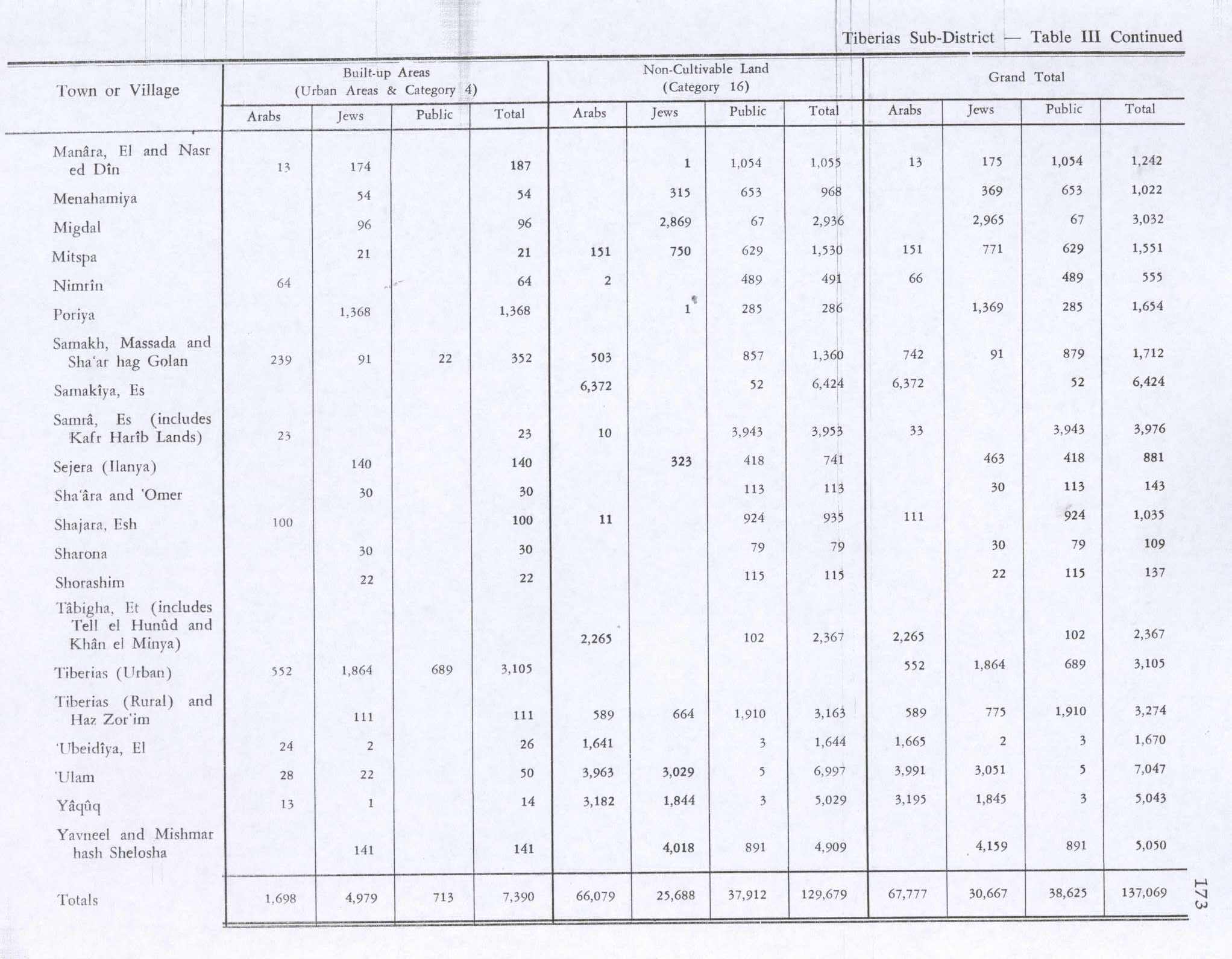
In the 1945 statistics the population consisted of 320 Muslims, [4] and the total land area was 12,019 dunams. [3] Of this, Arabs used 7,905 dunams for cereals, 335 for plantations and irrigable land, [14] while 64 dunams were classified as built-up (urban) area. [15]

1948 war, and aftermath

During the 1948 Arab-Israeli War, Nimrin fell into Israeli hands on July 17, 1948 after nearby Lubya was captured at the end of Operation Dekel. Its entire population of 320 (1945) fled for unclear reasons. According to Walid Khalidi, "the site and a major part of the lands are surrounded by a fence." [5]

See also

Related Research Articles

Umm al-Faraj Place in Acre, Mandatory Palestine

Umm al-Faraj, was a Palestinian village, depopulated in 1948.

Maalul Place in Nazareth, Mandatory Palestine

Ma'alul was a village, made up primarily of Palestinian Christians, that was depopulated and destroyed by Israel during the 1948 Arab-Israeli war. Located six kilometers west of the city of Nazareth, many of its inhabitants became internally displaced refugees, after taking refuge in Nazareth and the neighbouring town of Yafa an-Naseriyye. Despite having never left the territory that came to form part of Israel, the majority of the villagers of Maalul, and other Palestinian villages like Andor and Al-Mujidal, were declared "absentees", allowing the confiscation of their land under the Absentees Property Law.

Lubya Place in Tiberias, Mandatory Palestine

Lubya, sometimes referred to as Lubia, was a Palestinian Arab town located ten kilometers west of Tiberias that was captured and destroyed by Israel during the 1948 Arab-Israeli War where its residents were forcefully evacuated and became refugees. Nearby villages included Nimrin to the north, Hittin to the northwest, and al-Shajara to the south; Each of those villages were also depopulated.

Al-Mujaydil Place in Nazareth, Mandatory Palestine

Al-Mujaydil (Arabic: المْجيدل‎ was an Arab-Palestinian village located 6 km southwest of Nazareth. Al-Mujaydil was one of a few towns that achieved local council status by the Mandatory Palestine government. In 1945, the village had a population of 1,900 and total land area of 18,836 dunams – mostly Arab-owned. The population was partly Christian and the town contained a Roman Catholic church and monastery.

Indur Village in Nazareth, Mandatory Palestine

Indur was a Palestinian village, located 10.5 kilometres (6.5 mi) southeast of Nazareth. Its name preserves that of ancient Endor, a Canaanite city state thought to have been located 1 kilometre (0.62 mi) to the northeast. The village was depopulated during the 1948 Arab–Israeli War and its inhabitants became refugees, some of whom were internally displaced. In Israel today, there are a few thousand internally displaced Palestinians who hail from Indur, and continue to demand their right of return.

Al-Shajara, Tiberias Place in Tiberias, Mandatory Palestine

Al-Shajara was a Palestinian Arab village depopulated by Israel during the 1948 Arab-Israeli War when its residents were forcefully evacutaed and became refugees. It was located 14 kilometers west of Tiberias on the main highway to Nazareth near the villages of Lubya and Hittin. The village was very close to the city of Nazareth, about 5 kilometers away.

Qaddita Village in Safad, Mandatory Palestine

Qaddita was a Palestinian Arab village of 240, located 4.5 kilometers (2.8 mi) northwest of Safad. It was captured and depopulated in the 1948 Arab-Israeli War, with some of its inhabitants expelled or fleeing to nearby Akbara where they live as internally displaced Palestinians and others to refugee camps in Lebanon or Syria.

Kafr Sabt Village in Tiberias, Mandatory Palestine

Kafr Sabt was a Palestinian Arab village of nearly 500 situated on a sloping plain in the eastern Lower Galilee located 10.5 kilometers (6.5 mi) southwest of Tiberias. It was depopulated in 1948.

Awlam Village in Tiberias, Mandatory Palestine

Awlam was a Palestinian village 15 kilometres (9.3 mi) south of Tiberias situated on the slopes of the westward Wadi Awlam.

Dayr Sunayd Place in Gaza, Mandatory Palestine

Dayr Sunayd was a Palestinian Arab village in the Gaza Subdistrict, located 12 kilometers (7.5 mi) northeast of Gaza. Situated at an elevation of 50 meters (160 ft) along the southern coastal plain of Palestine, Deir Sunayd had a total land area of 6,081 dunams. Prior to its depopulation during the 1948 Arab–Israeli War, it had 730 inhabitants in 1945.

Bayt Tima Place in Gaza, Mandatory Palestine

Bayt Tima was a Palestinian Arab village in the Gaza Subdistrict, located 21 kilometers (13 mi) northeast of Gaza and some 12 kilometers (7.5 mi) from the coastline. It was situated in flat terrain on the southern coastal plain of Palestine. Bayt Tima was depopulated during the 1948 Arab-Israeli War. Its population in 1945 was 1,060.

Al-Batani al-Sharqi Place in Gaza, Mandatory Palestine

Al-Batani al-Sharqi was a Palestinian Arab village in the Gaza Subdistrict, located 36.5 kilometers (22.7 mi) northeast of Gaza situated in the flat terrain on the southern coastal plain of Palestine. It had a population of 650 in 1945. Al-Batani al-Sharqi was depopulated during the 1948 Arab-Israeli War.

Al-Jauna Village in Safad, Mandatory Palestine

Al-Ja'una or Ja'ouna, was a Palestinian village situated in Galilee near al-Houleh Plateau, overlooking the Jordan Valley. The village lay on a hillside 450–500 meters above sea level, 5 kilometers east of Safad near a major road connecting Safad with Tabariya. The Israeli town of Rosh Pinna sits on the former village site, which was expanded to include the depopulated Palestinian Al-Ja'una.

Sarafand al-Amar Village in Ramle, Mandatory Palestine

Sarafand al-Amar was a Palestinian Arab village situated on the coastal plain of Palestine, about 5 kilometers (3.1 mi) northwest of Ramla. It had a population of 1,950 in 1945 and a land area of 13,267 dunams. It was depopulated during the 1948 Arab–Israeli War.

Biriyya Place in Safad, Mandatory Palestine

Biriyya was a Palestinian Arab village in the Safad Subdistrict. It was depopulated during the 1947–1948 Civil War in Mandatory Palestine on May 2, 1948 by The Palmach's First Battalion of Operation Yiftach. It was located 1.5 kilometres (0.9 mi) northeast of Safad. Today the Israeli moshav of Birya includes the village site.

Fara, Safad Village in Safad, Mandatory Palestine

Fara was a Palestinian Arab village in the Safad Subdistrict. It was depopulated during the 1948 Arab-Israeli War on October 30, 1948 under Operation Hiram. It was located 11.5 km north of Safad on the Wadi al-Fara.

Firim Village in Safad, Mandatory Palestine

Fir'im was a Palestinian Arab village in the Safad Subdistrict that was depopulated during the 1948 Palestine war. It was first attacked during the 1947–1948 Civil War in Mandatory Palestine on May 2, 1948, by the Palmach's First Battalion during Operation Yiftach. In 1945 the population had been 740.

Qabbaa Village in Safad, Mandatory Palestine

Qabba'a was a Palestinian Arab village in the District of Safad. It was depopulated during the 1948 War on May 26, 1948 by the Palmach's First Battalion of Operation Yiftach. It was located 6 km northeast of Safad.

Hadatha Village in Tiberias, Mandatory Palestine

Hadatha, also El Hadetheh or Hadateh, was a Palestinian Arab village in the District of Tiberias, located 12.5 km southwest of Tiberias. It was depopulated in the 1947–1948 civil war in Mandatory Palestine.

Madhar Village in Tiberias, Mandatory Palestine

Ma'dhar was a Palestinian village in the Tiberias Subdistrict. It was depopulated during the 1947–1948 Civil War in Mandatory Palestine on May 12, 1948 by the Golani Brigade of Operation Gideon. It was located 12.5 km southwest of Tiberias.

References

  1. Palmer, 1881, p. 132
  2. Morris, 2004, p. xvii, village #95, also causes of depopulation, with a "?"
  3. 1 2 3 Government of Palestine, Department of Statistics. Village Statistics, April, 1945. Quoted in Hadawi, 1970, p. 72
  4. 1 2 Government of Palestine, Department of Statistics, 1945, p. 12
  5. 1 2 3 4 Khalidi, 1992, p.535
  6. Murray, 1997, p.165.
  7. Hütteroth and Abdulfattah, 1977, p. 189. Quoted in Khalidi, 1992, p. 535
  8. Note that Rhode, 1979, p. 6 writes that the register that Hütteroth and Abdulfattah studied was not from 1595/6, but from 1548/9
  9. Karmon, 1960, p. 166.
  10. Conder and Kitchener, 1881, SWP I, p. 361. Quoted in Khalidi, 1992, p. 535
  11. Schumacher, 1888, p. 185
  12. Barron, 1923, Table XI, Sub-district of Tiberias, p. 39
  13. Mills, 1932, p. 84
  14. Government of Palestine, Department of Statistics. Village Statistics, April, 1945. Quoted in Hadawi, 1970, p. 123
  15. Government of Palestine, Department of Statistics. Village Statistics, April, 1945. Quoted in Hadawi, 1970, p. 173

Bibliography