Wadi Ara was a Palestinian village located 38.5 km south of the city of Haifa. It is named after the nearby stream that is known in Arabic as Wadi 'Ara. The village was particularly small with a population of 230 and a land area of approximately 9,800 dunums.

Qannir was a Palestinian village, located 35 kilometers south of Haifa. With 750 inhabitants in 1945, it was depopulated in the lead up to the 1948 Arab-Israeli war.

Lazzaza was a Palestinian Arab village of 230 in the northern Hula Valley next to the Hasbani River, located 27.5 kilometers (17.1 mi) northwest of Safad. Beit Hillel subsequently expanded onto the land.

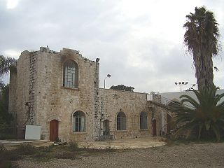
Al-Mansi was a Palestinian village in the Haifa Subdistrict. It was occupied on 12 April 1948 by Israeli troops during the Battle of Mishmar HaEmek. The village was inhabited by Turkmens.

Al-Nabi Yusha' was a small Palestinian village in the Galilee situated 17 kilometers to the northeast of Safad, with an elevation of 375 meters above sea level. It became part of the Palestine Mandate under British control from 1923 until 1948, when it was depopulated during the 1948 Arab-Israeli War. The village was surrounded by forest land overlooking the Hula Valley.

Al-'Abisiyya was a Palestinian Arab village in the District of Safad. It was depopulated during the 1948 Arab-Israeli War on May 29, 1948, by The Palmach's First Battalion of Operation Yiftach. It was located 28.5 km northeast of Safad near to the Banyas River which the village relied on for irrigation.

Arab al-Shamalina also known as Khirbat Abu Zayna was a Palestinian Arab village in the Safad Subdistrict. It was depopulated during the 1947–1948 Civil War in Mandatory Palestine on May 4, 1948, under Operation Matate (Broom), a sub operation of Operation Yiftach. It was located 13 km southeast of Safad near the Jordan River.

Fara was a Palestinian Arab village in the Safad Subdistrict. It was depopulated during the 1948 Arab-Israeli War on October 30, 1948, under Operation Hiram. It was located 11.5 km north of Safad on the Wadi al-Fara.

Ghabbatiyya was a Palestinian Arab hamlet in the Safad Subdistrict. It was depopulated during the 1948 Arab-Israeli War on October 30, 1948, under Operation Hiram. It was located 12 km northwest of Safad.

Harrawi was a Palestinian Arab village in the Safad Subdistrict. It was depopulated during the 1948 Arab-Israeli War on May 25, 1948, by the Palmach's First Battalion of Operation Yiftach. It was located 18 km northeast of Safad.

Al-Shawka al-Tahta was a Palestinian Arab village in the Safad Subdistrict. It was depopulated during the 1947–1948 Civil War in Mandatory Palestine on May 14, 1948, by the Palmach's First Battalion of Operation Yiftach. It was located 31.5 km northeast of Safad.

Al-Na'ima was a Palestinian Arab village in the Safad Subdistrict of Mandatory Palestine located 26 kilometres (16 mi) northeast of Safad, near the al-Hula Plain. The settlement was depopulated during the 1947-1948 civil war on May 14, 1948 by the Israeli Palmach's First Battalion as part of Operation Yiftach.

Al-Zuq al-Tahtani was a Palestinian Arab village in the Safad Subdistrict. It was depopulated during the 1947–1948 Civil War in Mandatory Palestine on May 11, 1948, by the Palmach's First Battalion of Operation Yiftach. It was located 30 km northeast of Safad.

Qaytiyya was a Palestinian Arab village in the Safad Subdistrict. It was depopulated during the 1948 War on May 19, 1948, by the Palmach's First Battalion of Operation Yiftach. It was located 28 km northeast of Safad, bordering both the Hasibani and the Dan Rivers.

Al-Zahiriyya al-Tahta was a Palestinian Arab village in the Safad Subdistrict. The village was on a descent at the southwestern part of Safad, a town 1 kilometer (0.62 mi) east of the village. Possibly named after the Mamluk sultan al-Zahir Baybars, the village was incorporated into the Safad Sanjak of the Ottoman Empire in 1517, and its entirely Muslim population paid fixed taxes, as well as taxes on winter pastures, an olive oil or grape syrup press and beehives during the 16th century. By the late 19th century, the population grew to 335 inhabitants, all Muslims. The population remained about the same in the last years of British Mandatory rule. The village lands spanned 6,773 dunums, nearly half of which were used to grow grains, the residents living on 28 dunums. Al-Zahiriyya al-Tahta was depopulated during the 1948 Palestine War when its inhabitants fled shortly after the capture of Safed by Jewish paramilitary forces.

Al-Sanbariyya was a Palestinian village in the Safad Subdistrict. It was depopulated during the 1947–1948 Civil War in Mandatory Palestine on May 1, 1948, by Palmach's First Battalion under Operation Yiftach. It was located 31.5 km northeast of Safad, near Wadi Hasibani.
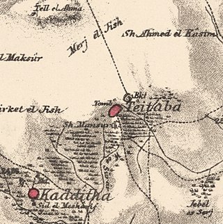
Taytaba was a Palestinian-Arab village in the Safad Subdistrict, located 5 kilometers north of Safad. It was depopulated during the 1947–1948 Civil War in Mandatory Palestine in May 1948 under Operation Hiram. In 1945 it had a population of 530 and a total area of 8,453 dunams, 99.8% of which was Arab-owned.

Tulayl was a Palestinian Arab village in the Safad Subdistrict located 14.5 kilometers (9.0 mi) northeast of Safad. It was situated on a hill near Lake Hula. Together with the nearby village of al-Husayniyya, it had a population of 340 in 1945. Tulayl was depopulated during the 1948 Palestine War.

Al-'Ulmaniyya was a Palestinian Arab village in the Safad Subdistrict. It was depopulated during the 1947–1948 Civil War in Mandatory Palestine on April 20, 1948, by the Palmach's First Battalion of Operation Yiftach. It was located 14.5 km northeast of Safad.

Al-'Ubaydiyya was a Palestinian Arab village in the Tiberias Subdistrict. It was depopulated during the 1948 Arab-Israeli War on March 3, 1948. It was located 11 km south of Tiberias, situated close to the Jordan River.
 1870s map
  1940s map
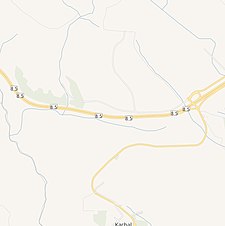 modern map
 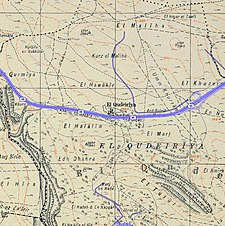 1940s with modern overlay map
