Al-Samakiyya

Last updated

Contents

Al-Samakiyya
تلحوم/السمكية
Village
La-tribu-des-semakich.jpg
Al-Samakiyya villagers, postcard from 1902
Etymology: ’Arab es Semakîyeh, the Semakîyeh (fisher) Arabs [1]
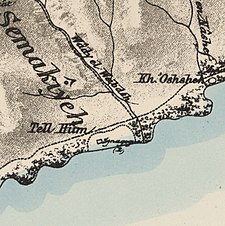
Historical map series for the area of al-Samakiyya (1870s).jpg 1870s map
Historical map series for the area of al-Samakiyya (1940s).jpg 1940s map
Historical map series for the area of al-Samakiyya (modern).jpg modern map
Historical map series for the area of al-Samakiyya (1940s with modern overlay).jpg 1940s with modern overlay map
A series of historical maps of the area around Al-Samakiyya (click the buttons)
Mandatory Palestine location map.svg
Red pog.svg
Al-Samakiyya
Location within Mandatory Palestine
Coordinates: 32°53′02″N35°34′41″E / 32.88389°N 35.57806°E / 32.88389; 35.57806
Palestine grid 204/254
Geopolitical entity Mandatory Palestine
Subdistrict Tiberias
Date of depopulationNot known [2]
Area
[3]
  Total
10,526  dunams (10.526 km2 or 4.064 sq mi)
Population
 (1945)
  Total
330 Muslims and 50 Christians connected to Capernaum ecclesiastic sites [4] [3]
Current Localities Amnun, [5] Korazim [5]

Al-Samakiyya was a Palestinian Arab village in the Tiberias Subdistrict. It was depopulated during the 1947–1948 Civil War in Mandatory Palestine on May 4, 1948, under Operation Matateh. It was located 11 km northeast of Tiberias, near the Wadi al-Wadabani. The village was located at Tel Hum, which has been identified with Capernaum. [6]

History

In 1838, Edward Robinson noted the bedawin (Bedouin) tribe of es-Semekiyeh, who kept some buildings in Abu Shusha as magazines. [7]

British Mandate

See of Galilee at Capernaum Al-Samakiyya.png
See of Galilee at Capernaum

In the 1922 census of Palestine conducted by the British Mandate authorities, the population of Samakiyeh was 193 Muslims, [8] increasing in the 1931 census to 290; 266 Muslims and 24 Christians,[ clarification needed ] in a total of 60 houses. [9]

In the 1945 statistics Es Samakiya had a population of 380; 330 Muslims and 50 Christians[ clarification needed ], [4] with 10,526 dunams of land. [3] Of this, 2 dunams were used for citrus and bananas, 66 for plantations and irrigable land, 4,034 dunams for cereals, [10] while a total of 6,424 dunams were classified as non-cultivable area. [11]

Al-Samakiyya had an Italian monastery, a Franciscan church, and a Greek Orthodox church. [5] [ clarification needed ]

1948 war and aftermath

On 4 May 1948, Yigal Allon launched Operation Matateh ('Operation Broom'), in order to clear the area of its Bedouin inhabitants. [2] [12] The Bedouin site is listed by Benny Morris as "'Arab al Samakiya (Samakiya/Talhum)". [2]

Historian Saleh Abdel Jawad writes that five or more villagers were killed in "indiscriminate" killings by the Haganah. [13]

Amnun and Korazim were both established on Al-Samakiyya land in 1983. [5]

In 1992, Palestinian historian Walid Khalidi wrote: "The village site is covered with wild vegetation, piles of basalt stones, and date palm trees. Part of the surrounding land is used as pasture, and the other part is planted with fruit and walnut trees." [5]

Related Research Articles

<span class="mw-page-title-main">Al-Nabi Rubin, Acre</span> Place in Acre, Mandatory Palestine

Al-Nabi Rubin, was a Palestinian village located 28 kilometers northeast of Acre. Al-Nabi Rubin students used to attend school in the nearby village of Tarbikha.

<span class="mw-page-title-main">Samakh, Tiberias</span> Place in Tiberias, Mandatory Palestine

Samakh was a Palestinian Arab village at the south end of Lake Tiberias in Ottoman Galilee and later Mandatory Palestine. It was the site of battle in 1918 during World War I.

<span class="mw-page-title-main">Al-Shajara, Palestine</span> Place in Tiberias, Mandatory Palestine

Al-Shajara was a Palestinian Arab village depopulated by Israel during the 1948 Arab-Israeli War when its residents were forcefully evacuated and became refugees. It was located 14 kilometers west of Tiberias on the main highway to Nazareth near the villages of Lubya and Hittin. The village was very close to the city of Nazareth, about 5 kilometers away.

<span class="mw-page-title-main">Nasir ad-Din, Palestine</span> Village in Tiberias, Mandatory Palestine

Nasir ad-Dīn was a small Palestinian Arab village 3 kilometers (1.9 mi) southwest of Tiberias, on the crest of a slope that overlooks the Sea of Galilee. The village had several springs to the east, south, and southeast. In the 1931 British census 179 people lived there, decreasing to 90 in a 1945 census. Nasir ad-Din and nearby al-Manara were in the same jurisdiction with 4,185 dunams of land, most of which was allocated to cereals.
<span class="mw-page-title-main">Kafr Sabt</span> Village in Tiberias, Mandatory Palestine

Kafr Sabt was a Palestinian Arab village of nearly 500 situated on a sloping plain in the eastern Lower Galilee located 10.5 kilometers (6.5 mi) southwest of Tiberias. It was depopulated in 1948.

<span class="mw-page-title-main">Awlam</span> Place in Tiberias, Mandatory Palestine

Awlam was a Palestinian village 15 kilometres (9.3 mi) south of Tiberias situated on the slopes of the westward Wadi Awlam.
<span class="mw-page-title-main">Arab al-Bawati</span> Village in Baysan, Mandatory Palestine

Arab al-Bawati, was a Palestinian Arab village in the District of Baysan. It was depopulated during the 1948 Arab-Israeli War.

<span class="mw-page-title-main">Arab al-Fuqara</span> Place in Haifa, Mandatory Palestine

Arab al-Fuqara was a Palestinian Arab village in the Haifa Subdistrict. It was depopulated during the 1947–1948 Civil War in Mandatory Palestine on April 10, 1948. At that time, the land records of the village consisted of a total area of 2,714 dunams, of which 2,513 were owned by Jews, 15 owned by Arabs, and the remaining 186 dunams being public lands.

<span class="mw-page-title-main">Khirbat Al-Dumun</span> Place in Haifa, Mandatory Palestine

Al-Dumun was a Palestinian Arab village in the Haifa Subdistrict. It was depopulated during the 1947–1948 Civil War in Mandatory Palestine on April 30, 1948. It was located 10.5 km southeast of Haifa.

<span class="mw-page-title-main">Khubbayza</span> Village in Haifa, Mandatory Palestine

Khubbayza was a Palestinian Arab village in the Haifa Subdistrict, located 29.5 kilometers (18.3 mi) southeast of Haifa. It was situated on hilly terrain, south of Wadi al-Sindiyana, between the Jezreel Valley with the Mediterranean coast. In 1945, it had a population of 290. Khubbayza was depopulated during the 1948 War on May 12, 1948, in the Battle of Mishmar HaEmek.

<span class="mw-page-title-main">Al-Rihaniyya</span> Arab village in Haifa subdistrict, Mandatory Palestine

Al-Rihaniyya was a Palestinian Arab village in the Haifa Subdistrict. It was depopulated during the 1947–1948 Civil War in Mandatory Palestine on 30 April 1948 as part of the battle of Mishmar HaEmek. It was located 25 km southeast of Haifa and 3 km northwest of Wadi al-Mileh.

<span class="mw-page-title-main">Al-Sawalima</span> Former village in Jaffa, Mandatory Palestine

Al-Sawalima was a Palestinian Arab village in the Jaffa Subdistrict. It was depopulated during the 1947–1948 Civil War in Mandatory Palestine on March 30, 1948. It was located 11 km northeast of Jaffa, situated 2 km north of the al-'Awja River.

<span class="mw-page-title-main">Arab al-Shamalina</span> Place in Safad, Mandatory Palestine

Arab al-Shamalina also known as Khirbat Abu Zayna was a Palestinian Arab village in the Safad Subdistrict. It was depopulated during the 1947–1948 Civil War in Mandatory Palestine on May 4, 1948, under Operation Matate (Broom), a sub operation of Operation Yiftach. It was located 13 km southeast of Safad near the Jordan River.

<span class="mw-page-title-main">Al-Zanghariyya</span> Village in Safad, Mandatory Palestine

Al-Zanghariyya was a Palestinian Arab village in the Safad Subdistrict. It was depopulated during the 1947–1948 Civil War in Mandatory Palestine on May 4, 1948, under Operation Matateh. It was located 8.5 km southeast of Safad, near Wadi al-Ghara. The village was later burned and destroyed on June 17, 1948.

<span class="mw-page-title-main">Al-Qudayriyya</span> Village in Safad, Mandatory Palestine

Al-Qudayriyya was a Palestinian Arab village in the Safad Subdistrict. It was depopulated during the 1947–1948 Civil War in Mandatory Palestine on May 4, 1948, by the Haganah and the Palmach's First Battalion of Operation Matate, a sub-operation of Operation Yiftach. It was located 6.5 km south of Safad, situated 1 km east of Wadi al-'Amud.
<span class="mw-page-title-main">Al-Salihiyya, Palestine</span> Place in Safad, Mandatory Palestine

Al-Salihiyya was a Palestinian Arab village populated by people traditionally associated with the Ghawarna, a generic exonym denoting inhabitants of the drainage plains of the Hula Valley. It was depopulated during the 1948 War on May 25, 1948, by the Israeli Palmach. It was located in the Safad Subdistrict, 25 km northeast of Safad, at the intersection of the Jordan River and Wadi Tur'an.

<span class="mw-page-title-main">Ghuwayr Abu Shusha</span> Place in Tiberias, Mandatory Palestine

Ghuwayr Abu Shusha was a Palestinian Arab village in the Tiberias Subdistrict. It was depopulated during the 1947–1948 Civil War in Mandatory Palestine on April 21, 1948. It was located 8 km north of Tiberias, nearby Wadi Rubadiyya.

<span class="mw-page-title-main">Hadatha</span> Place in Tiberias, Mandatory Palestine

Hadatha, also El Hadetheh or Hadateh, was a Palestinian Arab village in the District of Tiberias, located 12.5 km southwest of Tiberias. It was depopulated in the 1947–1948 civil war in Mandatory Palestine.

<span class="mw-page-title-main">Al-Manara, Palestine</span> Village in Tiberias, Mandatory Palestine

Al-Manara was a Palestinian Arab village in the Tiberias Subdistrict. It was depopulated during the 1947–1948 Civil War in Mandatory Palestine on March 1, 1948, by Jewish troops. It was located 5 km south of Tiberias.

<span class="mw-page-title-main">Ubeidiya, Tiberias</span> Former Palestinian village near Tiberias

Al-'Ubaydiyya was a Palestinian Arab village in the Tiberias Subdistrict. It was depopulated during the 1948 Arab-Israeli War on March 3, 1948. It was located 11 km south of Tiberias, situated close to the Jordan River.

References

  1. Palmer, 1881, p. 123
  2. 1 2 3 Morris, 2004, p. xvii, village #373. Gives both date and cause of depopulation as "Not known"
  3. 1 2 3 Government of Palestine, Department of Statistics. Village Statistics, April, 1945. Quoted in Hadawi, 1970, p. 72
  4. 1 2 Department of Statistics, 1945, p. 12
  5. 1 2 3 4 5 Khalidi, 1992, p. 539
  6. Conder and Kitchener, 1881, SWP I, pp. 371, 417
  7. Robinson and Smith, 1841, vol 3, p. 286, cited in Khalidi, 1992, p. 539
  8. Barron, 1923, Table IX, Sub-district of Tiberias, p. 40
  9. Mills, 1932, p. 85
  10. Government of Palestine, Department of Statistics. Village Statistics, April, 1945. Quoted in Hadawi, 1970, p. 123
  11. Government of Palestine, Department of Statistics. Village Statistics, April, 1945. Quoted in Hadawi, 1970, p. 173
  12. Morris, 2004, pp. 249-250, notes #694-698, p. 302
  13. Saleh Abdel Jawad, 2007, Zionist Massacres: the Creation of the Palestinian Refugee Problem in the 1948 War. "4 May 1948: [...] As Samakiyya (‘Arab al-Samakiyya near Tiberias): Indiscriminate killings occur. The Haganah fires on fleeing civilians and kill at least three individuals from Tabigha, who had taken refuge in As Samakiyya. Among the dead are Ahmad Muhammed, Ahmad Abu-Fadil, Hamdih Khadrah, and the sister of Ahmad Yousef Ali."

Bibliography