Al-Mazar, Jenin

Last updated

Contents

Al-Mazar
المزار
Village
Etymology: "shrine", "a place one visits" [1]
Historical map series for the area of Al-Mazar, Jenin (1870s).jpg 1870s map
Historical map series for the area of Al-Mazar, Jenin (1940s).jpg 1940s map
Historical map series for the area of Al-Mazar, Jenin (modern).jpg modern map
Historical map series for the area of Al-Mazar, Jenin (1940s with modern overlay).jpg 1940s with modern overlay map
A series of historical maps of the area around Al-Mazar, Jenin (click the buttons)
Mandatory Palestine location map.svg
Red pog.svg
Al-Mazar
Location within Mandatory Palestine
Coordinates: 32°31′38″N35°21′33″E / 32.52722°N 35.35917°E / 32.52722; 35.35917
Palestine grid 184/214
Geopolitical entity Mandatory Palestine
Subdistrict Jenin
Date of depopulation30 May 1948 [2]
Area
[3]
  Total
14,501  dunams (14.501 km2 or 5.599 sq mi)
Population
 (1945)
  Total
270 [4] [3]
Cause(s) of depopulationMilitary assault by Yishuv forces
Current Localities Prazon, Meitav, and Gan Ner

Al-Mazar (Arabic : المزار) was a Palestinian Arab village in the District of Jenin. Situated on Mount Gilboa, its history stretched back to the period of Mamluk rule over Palestine (13th century). An agricultural village, its villagers traced their ancestry to nomads descended from a Sufi mystic from Jaba', Syria. [5] [6]

Al-Mazar was depopulated during the 1948 Palestine war, and incorporated into the newly established state of Israel. [5] The Israeli villages of Prazon, Meitav, and Gan Ner were established on al-Mazar's former lands.

Location

The village was located on the flat, circular peak of the mountain known in biblical scripture as Mount Gilboa, and locally as Mount al-Mazar or Djebel Foukou'ah ("Mount of Mushrooms"), with steep slopes on all sides excepting the southeast. [5] [7] It was joined to the neighbouring village of Nuris by a dirt path. [5]

History

The village may have been named al-Mazar (Arabic for "shrine", "a place one visits" [1] ) because it was a burial place of many of those who fell in the Battle of Ain Jalut between the Mamluks and the Mongols in 1260. [5]

The villagers traced their origins to the al-Sadiyyun nomads, who in turn were descended from Shaykh Sad al-Din al-Shaybani (died 1224), a prominent Sufi mystic from the Jaba' village on the Golan. [5] [6] Another tradition traces their ancestry to Libya. [6]

Ottoman era

During the period of Ottoman rule over Palestine, al-Mazar was captured and burned by Napoleon's troops in April 1799 during the Syrian leg of his military campaign in Egypt. [8] Pierre Jacotin named the village Nazer on his map from that campaign. [9]

In 1870, V. Guérin visited al-Mazar, describing it as a village with about 500 inhabitants, situated at the peak of Djebel Foukou'ah, and surrounded by a belt of gigantic cactus plants. Numerous wells carved in the rock were said to point to the antiquity of the village. From the village, he could see the whole of Djebel Foukou'ah, which he identifies as the Mount Gilboa of biblical scripture, as well as the Jezreel Valley, the Little Hermon (actually Djebel Dhahy), Mount Tabor, and further north, the snowy peaks of Mount Hermon. Also seen from the village to the west and northwest were the Plain of Esdraelon and the Carmel Mountains; to the south, the mountains around Jenin; and to the east, before the Jordan River, what he calls the ancient country of Galaad. He notes that the name of Mount Gilboa is preserved in the name of the village of Djelboun, also situated on the mountain. Descending the mountain towards the west-southwest, at the base of the village of al-Mazar, he notes the presence of a spring of the same name, Ain el-Mezar, and on the slopes of this side of the mountain, which are less steep, there were olive trees and wheat being cultivated. [7]

In the 1882 the PEF's Survey of Western Palestine (SWP) described the place as: "a village on the summit of the mountain. It is principally built of stone, and has a well to the south-east. A few olives surround the houses. The site is very rocky. It is inhabited by Derwishes, and is a place of Muslim pilgrimage." [10]

British Mandate era

In the 1922 census of Palestine, conducted by the British Mandate authorities, al-Mazar had a population of 223, all Muslims, [11] increasing slightly in the 1931 census to 257, still all Muslims, in a total of 62 inhabited houses. [12] The village was home to Sheik Farhan al Sadi, a prominent leader in the 1936 Arab revolt in Palestine. [5] In 1937, at the age of 75, he was executed by the British authorities for his participation in the revolt. [13]

Agriculture was the backbone of the village economy, which was based on grain, fruit, legume, and olive cultivation. In the 1945 statistics the population of Al-Mazar was 270 Muslims, [4] with a total of 14,501 dunams of land. [3] Of this, 5,221 dunums were used for cereals, 229 dunums were irrigated or used for orchards, of which 68 dunums were for olives, [5] [14] while 9 dunams were built-up (urban) land. [15]

Farhan al-Sa'di (1856–1937) was born in al-Mazar. He is thought to be the first to use a weapon during the 1936 revolt. [16]

1948 and aftermath

On 19 April 1948, Palmah HQ (headquarters) ordered the OC (operational command) of the First Battalion to, "destroy enemy bases in Mazar, Nuris and Zir'in [..] Comment: with the capture of Zir'in, most of the village houses must be destroyed while [some] should be left intact for accommodation and defence." According to Benny Morris, the Israeli historian, the policy of destroying the Palestinian villages was characteristic of Haganah attacks in April–May 1948, just before the outbreak of the 1948 Arab–Israeli war. [17] However, the specific orders for al-Mazar were either not acted upon, or did not succeed at once, as the village was not occupied until 30 May 1948. [2] [5] By that time, it had been captured after an attack by Israeli soldiers from the Golani Brigade, along with the village of Nuris, which lay at the foot of the mountain. [8]

Following the war, the area was incorporated into the State of Israel and three villages were subsequently established on the land of al-Mazar; Prazon in 1953, Meitav in 1954, and Gan Ner in 1987. [5] The Palestinian historian Walid Khalidi described what remained of al-Mazar in 1992:

The site is overgrown with thorns and cactuses and strewn with stone rubble. None of the village houses or landmarks remains. Almond trees and cactuses grow on parts of the village lands. The hilly lands are used as grazing areas, and other parts are covered with forest. [18]

Folklore

According to local tradition, the ancestral mother of the local al-Sadiyyun clan, Halima al-Sa'adi, was a Bedouin woman who breastfed the Islamic Prophet Muhammad. It is said that the prophet's mother entrusted the infant to a Bedouin woman to breastfeed him. Members of the clan say Halima nursed Muhammad in the house of his uncle following his mother's death when Muhammad was six years old. [6]

Related Research Articles

<span class="mw-page-title-main">Danna, Baysan</span> Place in Baysan, Mandatory Palestine

Danna, was a Palestinian village 13 kilometres north of Baysan that was captured by the Israel Defense Forces during the 1948 Arab-Israeli war, and the villagers were expelled.

al-Nahr Place in Acre, Mandatory Palestine

al-Nahr, was a Palestinian village 14 km (8.7 mi) northeast of Acre. It was depopulated in May 1948 after a military assault carried out by the Carmeli Brigade as part of the Israel Defense Forces's Operation Ben-Ami. Immediately after the assault, the village of al-Nahr was razed.

<span class="mw-page-title-main">Zir'in</span> Place in Jenin, Mandatory Palestine

Zir'in, also spelled Zerin and Zerein, was a Palestinian Arab village of over 1,400 in the Jezreel Valley, located 11 kilometers (6.8 mi) north of Jenin. Identified as the ancient town of Yizre'el (Jezreel), it was known as Zir'in during Islamic rule, and was near the site of the Battle of Ain Jalut, in which the Mamluks halted Mongol expansion southward. Under the Ottomans, it was a small village, expanding during the British Mandate in the early 20th century. After its capture by Israel in 1948, Zir'in was destroyed. The Israeli kibbutz of Yizre'el was established shortly after on the village lands of Zir'in.

<span class="mw-page-title-main">Bayt Naqquba</span> Arab village in Mandatory Palestine

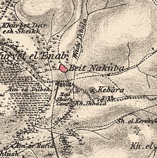
Bayt Naqquba was a Palestinian village in British Mandate Palestine, located 9.5 kilometers west of Jerusalem, near Abu Ghosh. Before Palmach and Haganah troops occupied the village during Operation Nachshon on April 11, 1948, approximately 300 Palestinian Arabs lived there. After the 1948 Arab–Israeli War, a moshav named Beit Nekofa was founded close to the site by Jewish immigrants from Yugoslavia. In 1962, residents of Bayt Naqubba built a new village named Ein Naqquba, south of Beit Nekofa.

<span class="mw-page-title-main">Ra'na</span> Place in Hebron, Mandatory Palestine

Ra'na was a village located approximately 26 km northwest of Hebron. It was occupied by the Israeli army during Operation Yo'av in October 1948. It was one of 16 villages in the Hebron district that were depopulated.

<span class="mw-page-title-main">Qumya</span> Village in Baysan, Mandatory Palestine

Qumya, was a Palestinian village of 510 inhabitants when it was depopulated prior to the 1948 Arab-Israeli war.

<span class="mw-page-title-main">Yubla</span> Village in Baysan, Mandatory Palestine

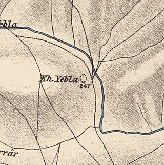
Yubla, was a Palestinian village, located 9 kilometers north of Bisan in present-day Israel. It was depopulated during the 1948 Arab-Israeli war.

<span class="mw-page-title-main">Sabbarin</span> Place in Haifa, Mandatory Palestine

Subbarin was a Palestinian Arab village located 28 kilometers south of Haifa. It was depopulated and destroyed during the 1948 Palestine war as part of the 1948 Palestinian expulsion and the Nakba.

<span class="mw-page-title-main">Shahma</span> Village in Ramle, Mandatory Palestine

Shahma was a Palestinian Arab village located 15 kilometers (9.3 mi) southwest of Ramla. Depopulated on the eve of the 1948 Arab-Israeli war, the village lands today form part of a fenced-in area used by the Israeli Air Force.

<span class="mw-page-title-main">Al-Murassas</span> Place in Baysan, Mandatory Palestine

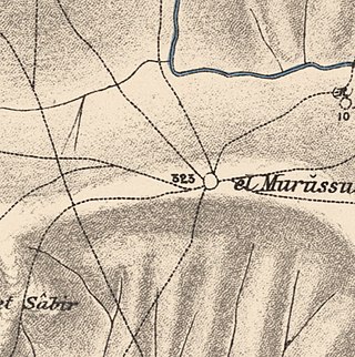
Al-Murassas, was a Palestinian Arab village in the District of Baysan. It was depopulated by the Israel Defense Forces during the 1948 War on May 16, 1948. The village was attacked as part of Operation Gideon.

<span class="mw-page-title-main">Bayt Umm al-Mays</span> Place in Jerusalem, Mandatory Palestine

Bayt Umm al-Mays was a small Palestinian Arab village in the Jerusalem Sub-district, located 14 km west of Jerusalem..

<span class="mw-page-title-main">Al-Barriyya</span> Place in Ramle, Mandatory Palestine

Al-Barriyya was a Palestinian village in the Ramle Subdistrict of Mandatory Palestine. It was depopulated during the 1948 Arab–Israeli War on July 10, 1948, as part of Operation Dani. It was located 5.5 km southeast of Ramla, on the eastern bank of Wadi al-Barriyya.

<span class="mw-page-title-main">Al-Khayma</span> Village in Ramle, Mandatory Palestine

Al-Khayma was a Palestinian Arab village in the Ramle Subdistrict of Mandatory Palestine. It was depopulated during the 1948 Arab–Israeli War on July 9, 1948, by the Givati Brigade of Operation An-Far. It was located 18.5 km south of Ramla.

<span class="mw-page-title-main">Al-Mansura, Ramle</span> Village in Ramle, Mandatory Palestine

Al-Mansura was a small Palestinian Arab village in the Ramle Subdistrict, located 10 km south of Ramla. It was depopulated during the 1947–48 Civil War in Mandatory Palestine on April 20, 1948, under Operation Barak.

<span class="mw-page-title-main">Al-Qubayba, Ramle</span> Arab village in Mandatory Palestine

Al-Qubayba was a Palestinian Arab village in the Ramle Subdistrict. It was depopulated during the 1948 Arab-Israeli War on May 27, 1948, by the Givati Brigade as part of the Second stage of Operation Barak. It was located 10.5 km southeast of Ramla near the Rubin River which provided the village with water and irrigation for agriculture. Al-Qubayba was mostly destroyed with the exception of a few houses, and Kfar Gevirol was built in its place, now a suburb in the west of Rehovot.

<span class="mw-page-title-main">Harrawi</span> Village in Safad, Mandatory Palestine

Harrawi was a Palestinian Arab village in the Safad Subdistrict. It was depopulated during the 1948 Arab-Israeli War on May 25, 1948, by the Palmach's First Battalion of Operation Yiftach. It was located 18 km northeast of Safad.

<span class="mw-page-title-main">Jahula</span> Place in Safad, Mandatory Palestine

Jahula was a Palestinian Arab village in the Safad Subdistrict. It was depopulated during the 1947–1948 civil war in Mandatory Palestine on May 1, 1948, by the Palmach's First Battalion of Operation Yiftach. It was located 11 km northeast of Safad.

<span class="mw-page-title-main">Al-Zuq al-Fawqani</span> Village in Safad, Mandatory Palestine

Al-Zuq al-Fawqani was a Palestinian Arab village in the Safad Subdistrict. It was depopulated during the 1948 Arab-Israeli War on May 21, 1948, by the Palmach's First Battalion of Operation Yiftach. It was located 32 km northeast of Safad.

<span class="mw-page-title-main">Khirbat al-Zababida</span> Place in Tulkarm, Mandatory Palestine

Khirbat al-Zababida was a Palestinian Arab village in the Tulkarm Subdistrict. It was depopulated during the 1948 Arab–Israeli War on May 15, 1948. It was located 20 kilometres (12 mi) southwest of Tulkarm, south of Wadi al-Faliq. Khirbat al-Zababida was mostly destroyed except for four deserted houses.

<span class="mw-page-title-main">Nuris</span> Place in Jenin, Mandatory Palestine

Nuris was a Palestinian Arab village in the District of Jenin. In 1945, Nuris had 570 inhabitants. It was depopulated during the 1948 War on 29 May 1948 under Operation Gideon. The Israeli moshav of Nurit was built on Nuris' village land in 1950.
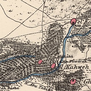
References

  1. 1 2 Palmer, 1881, p. 165
  2. 1 2 Morris, 2004, p. xvii, village #122. Also gives cause of depopulation
  3. 1 2 3 Government of Palestine, Department of Statistics. Village Statistics, April, 1945. Quoted in Hadawi, 1970, p. 54 Archived 2012-02-29 at the Wayback Machine
  4. 1 2 Government of Palestine, Department of Statistics, 1945, p. 16 Archived 2018-09-05 at the Wayback Machine
  5. 1 2 3 4 5 6 7 8 9 10 Khalidi, 1992, p. 337
  6. 1 2 3 4 זהרוני, אילן (1996). "משפחות קדושות ועושי נפלאות באזור הגלבוע" [Holy families and miracle workers in the Gilboa region]. In שילר, אלי (ed.). דת ופולחן וקברי קדושים מוסלמים בארץ-ישראל. אריאל: כתב עת לידיעת ארץ ישראל (in Hebrew). ירושלים: הוצאת ספרים אריאל. p. 170.
  7. 1 2 Guérin, 1874, p.325
  8. 1 2 Cline, 2002, pp. 161-2, 169
  9. Karmon, 1960, p. 169 Archived 2017-12-01 at the Wayback Machine
  10. Conder and Kitchener, 1882, SWP II, p. 85
  11. Barron, 1923, Table IX, Sub-district of Jenin, p. 29
  12. Mills, 1932, p. 69
  13. Palestine: Acre Justice, Dec. 06, 1937, Time magazine
  14. Government of Palestine, Department of Statistics. Village Statistics, April, 1945. Quoted in Hadawi, 1970, p. 99
  15. Government of Palestine, Department of Statistics. Village Statistics, April, 1945. Quoted in Hadawi, 1970, p. 149
  16. "Documents, Correspondence & Photos - Image 133/316" . Retrieved 14 December 2013.
  17. Morris, 2004, p. 346
  18. Khalidi, 1992, p. 338

Bibliography