Al-Dalhamiyya

Last updated

Contents

Al-Dalhamiyya
الدلهمية
Village
Etymology: from a family name [1]
Historical map series for the area of al-Dalhamiyya (1940s).jpg 1940s map
Historical map series for the area of al-Dalhamiyya (modern).jpg modern map
Historical map series for the area of al-Dalhamiyya (1940s with modern overlay).jpg 1940s with modern overlay map
A series of historical maps of the area around Al-Dalhamiyya (click the buttons)
Mandatory Palestine location map.svg
Red pog.svg
Al-Dalhamiyya
Location within Mandatory Palestine
Coordinates: 32°39′38″N35°35′52″E / 32.66056°N 35.59778°E / 32.66056; 35.59778
Palestine grid 204/230
Geopolitical entity Mandatory Palestine
Subdistrict Tiberias
Date of depopulationApril 15, 1948
Area
  Total
2,852  dunams (2.852 km2 or 1.101 sq mi)
Population
 (1945)
  Total
410 [2] [3]

Al-Dalhamiyya (Arabic : الدلهمية) was a Palestinian Arab village in the Tiberias Subdistrict. It was depopulated during the 1947–1948 Civil War in Mandatory Palestine on April 15, 1948, under Operation Gideon. It was located 14 km south of Tiberias, on the north bank of the Yarmuk River, on the border between Mandatory Palestine and Transjordan.

History

Ottoman era

1858 map of the area - the location marked as Al-Dalhamiyya is the current location of Ashdot Ya'akov. Al-Dalhamiyya in VanDeVeldeMap5 (cropped).jpg
1858 map of the area – the location marked as Al-Dalhamiyya is the current location of Ashdot Ya'akov.

In 1838 Al-Dalhamiyya was pointed out to Edward Robinson during his travels in the area, as being located on the eastern bank, about half a mile above the mouth of the Yarmuk. [4]

In 1875 Victor Guérin noted that the houses of the village were built of adobe, and most were surmounted by reed huts. [5] The same year C. R. Conder called it a "miserable" adobe hamlet. [6] [7] A population list from about 1887 showed ed Delhamiyeh wa ’Arab el Hanady to have about 650 inhabitants; all Muslims. [8]

Menachemya was founded by Zionist in 1902, close to the village, but not on village land. [9]

British Mandate era

Al-Dalhamiyya train stop in the 1930s Al-Dalhamiyya train stop in the 1930s.jpg
Al-Dalhamiyya train stop in the 1930s

At the time of the 1922 census of Palestine conducted by the British Mandate authorities, Delhamiyeh had a population of 352; 349 Muslims and 3 Jews, [10] decreasing to 240; 226 Muslims, 1 Jew and 13 Christians, living in 50 houses by the 1931 census. [11]

Ashdot Ya'aqov, southwest to the village site, and Ashdot Ya'aqov Me'uchad, west of the village site, were settled by Zionist in 1933, but none on village land. [9]

In the 1944/1945 statistics, the village had a population of 410; 390 Muslims and 20 Christians, [2] with a total of 2,852 dunams of land. [3] Of this, Arabs used 29 dunams for plantations and irrigable land, 1,709 dunams were used for cereals, [12] while a total of 442 dunams were un-cultivable. [13]

1948, aftermath

Historians say the details of the depopulation of the village remain unclear, but they expect it was captured in mid- to late April 1948, when neighboring Samakh was taken. By May 3, 1948, it was reported to the Jewish National Fund that the area surrounding Lake Tiberias had been emptied of Arab inhabitants. [14]

In 1992, the village site was described thus by historian Walid Khalidi: "The village has been obliterated. There is a banana grove on the site that belongs to the nearby kibbutz, Ashdod Ya'aqov." [9]

Related Research Articles

<span class="mw-page-title-main">Suruh</span> Village in Acre, Mandatory Palestine

Suruh, was a Palestinian Arab hamlet, located 28.5 kilometers (17.7 mi) northeast of Acre. It became depopulated in the 1948 Arab-Israeli war.

<span class="mw-page-title-main">Ma'alul</span> Place in Nazareth, Mandatory Palestine

Ma'alul was a Palestinian village, with a mixed population of primarily Muslims with a substantial minority of Palestinian Christians, that was depopulated and destroyed by Israel during the 1948 Arab-Israeli war. Located six kilometers west of the city of Nazareth, many of its inhabitants became internally displaced refugees, after taking refuge in Nazareth and the neighbouring town of Yafa an-Naseriyye. Despite having never left the territory that came to form part of Israel, the majority of the villagers of Maalul, and other Palestinian villages like Andor and Al-Mujidal, were declared "absentees", allowing the confiscation of their land under the Absentees Property Law.

<span class="mw-page-title-main">Miska, Tulkarm</span> Village in Tulkarm, Mandatory Palestine

Miska was a Palestinian village, located fifteen kilometers southwest of Tulkarm, depopulated in 1948.

<span class="mw-page-title-main">Al-Shajara, Palestine</span> Place in Tiberias, Mandatory Palestine

Al-Shajara was a Palestinian Arab village depopulated by Israel during the 1948 Arab-Israeli War when its residents were forcefully evacuated and became refugees. It was located 14 kilometers west of Tiberias on the main highway to Nazareth near the villages of Lubya and Hittin. The village was very close to the city of Nazareth, about 5 kilometers away.

<span class="mw-page-title-main">Kafr Sabt</span> Village in Tiberias, Mandatory Palestine

Kafr Sabt was a Palestinian Arab village of nearly 500 situated on a sloping plain in the eastern Lower Galilee located 10.5 kilometers (6.5 mi) southwest of Tiberias. It was depopulated in 1948.

<span class="mw-page-title-main">Kafra, Baysan</span> Place in Baysan, Mandatory Palestine

Kafra, was a Palestinian Arab village located 10.5 kilometres north of Baysan. Built along both sides of the Wadi Kafra, the village had been known by this name since at least the time of the Crusades. It was depopulated by the Israel Defense Forces during the 1948 Palestine War on May 16, 1948.

<span class="mw-page-title-main">Khubbayza</span> Village in Haifa, Mandatory Palestine

Khubbayza was a Palestinian Arab village in the Haifa Subdistrict, located 29.5 kilometers (18.3 mi) southeast of Haifa. It was situated on hilly terrain, south of Wadi al-Sindiyana, between the Jezreel Valley with the Mediterranean coast. In 1945, it had a population of 290. Khubbayza was depopulated during the 1948 War on May 12, 1948, in the Battle of Mishmar HaEmek.

<span class="mw-page-title-main">Al-Khayma</span> Village in Ramle, Mandatory Palestine

Al-Khayma was a Palestinian Arab village in the Ramle Subdistrict of Mandatory Palestine. It was depopulated during the 1948 Arab–Israeli War on July 9, 1948, by the Givati Brigade of Operation An-Far. It was located 18.5 km south of Ramla.

<span class="mw-page-title-main">Arab al-Shamalina</span> Place in Safad, Mandatory Palestine

Arab al-Shamalina also known as Khirbat Abu Zayna was a Palestinian Arab village in the Safad Subdistrict. It was depopulated during the 1947–1948 Civil War in Mandatory Palestine on May 4, 1948, under Operation Matate (Broom), a sub operation of Operation Yiftach. It was located 13 km southeast of Safad near the Jordan River.

<span class="mw-page-title-main">Al-Zuq al-Tahtani</span> Village in Safad, Mandatory Palestine

Al-Zuq al-Tahtani was a Palestinian Arab village in the Safad Subdistrict. It was depopulated during the 1947–1948 Civil War in Mandatory Palestine on May 11, 1948, by the Palmach's First Battalion of Operation Yiftach. It was located 30 km northeast of Safad.

<span class="mw-page-title-main">Al-Shuna</span> Village in Safad, Mandatory Palestine

Al-Shuna was a Palestinian Arab village in the Safad Subdistrict. It was ethnically cleansed and depopulated during the 1947–1948 Civil War in Mandatory Palestine on April 30, 1948, by the Palmach's First Battalion of Operation Yiftach. It was located 6 km south of Safad, overlooking the deep gorge of Wadi al-'Amud.

<span class="mw-page-title-main">Al-Sanbariyya</span> Place in Safad, Mandatory Palestine

Al-Sanbariyya was a Palestinian village in the Safad Subdistrict. It was depopulated during the 1947–1948 Civil War in Mandatory Palestine on May 1, 1948, by Palmach's First Battalion under Operation Yiftach. It was located 31.5 km northeast of Safad, near Wadi Hasibani.

<span class="mw-page-title-main">Ghuwayr Abu Shusha</span> Place in Tiberias, Mandatory Palestine

Ghuwayr Abu Shusha was a Palestinian Arab village in the Tiberias Subdistrict. It was depopulated during the 1947–1948 Civil War in Mandatory Palestine on April 21, 1948. It was located 8 km north of Tiberias, nearby Wadi Rubadiyya.

<span class="mw-page-title-main">Hadatha</span> Place in Tiberias, Mandatory Palestine

Hadatha, also El Hadetheh or Hadateh, was a Palestinian Arab village in the District of Tiberias, located 12.5 km southwest of Tiberias. It was depopulated in the 1947–1948 civil war in Mandatory Palestine.

<span class="mw-page-title-main">Al-Manara, Palestine</span> Village in Tiberias, Mandatory Palestine

Al-Manara was a Palestinian Arab village in the Tiberias Subdistrict. It was depopulated during the 1947–1948 Civil War in Mandatory Palestine on March 1, 1948, by Jewish troops. It was located 5 km south of Tiberias.

<span class="mw-page-title-main">Yaquq</span> Village in Tiberias, Mandatory Palestine

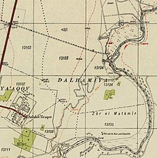
Yaquq was a Palestinian Arab village, which was depopulated during the 1947–1948 Civil War in Mandatory Palestine on May 1, 1948. It was located 12.5 km north of Tiberias and was built at the site of the ancient Jewish village of Huqoq.

<span class="mw-page-title-main">Al-Manshiyya, Tiberias</span> Village in Tiberias, Mandatory Palestine

Al-Manshiyya was a Palestinian Arab village in the Tiberias Subdistrict, located 11 kilometres south of Tiberias. It was probably depopulated at the same time as neighbouring Al-'Ubaydiyya, in the 1947–1948 Civil War in Mandatory Palestine. Manshiyya was located 1 km south-west of Umm Junieh or Khirbat Umm Juni.

<span class="mw-page-title-main">Al-Mansura, Tiberias</span> Village in Tiberias, Mandatory Palestine

Al-Mansura was a Palestinian Arab village in the Tiberias Subdistrict. It was depopulated during the 1947–1948 Civil War in Mandatory Palestine on May 10, 1948. It was located 16 kilometres northwest of Tiberias.

<span class="mw-page-title-main">Ubeidiya, Tiberias</span> Former Palestinian village near Tiberias

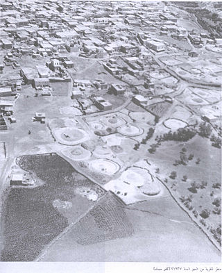
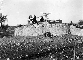
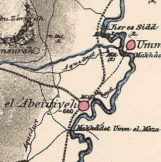
Al-'Ubaydiyya was a Palestinian Arab village in the Tiberias Subdistrict. It was depopulated during the 1948 Arab-Israeli War on March 3, 1948. It was located 11 km south of Tiberias, situated close to the Jordan River.

<span class="mw-page-title-main">Al-Samakiyya</span> Village in Tiberias, Mandatory Palestine

Al-Samakiyya was a Palestinian Arab village in the Tiberias Subdistrict. It was depopulated during the 1947–1948 Civil War in Mandatory Palestine on May 4, 1948, under Operation Matateh. It was located 11 km northeast of Tiberias, near the Wadi al-Wadabani. The village was located at Tel Hum, which has been identified with Capernaum.

References

  1. Palmer, 1881, p. 160
  2. 1 2 Department of Statistics, 1945, p. 12
  3. 1 2 Government of Palestine, Department of Statistics. Village Statistics, April, 1945. Quoted in Hadawi, 1970, p. 72
  4. Robinson and Smith, 1841, vol. 3, p. 264
  5. Guérin, 1880, p. 284
  6. Conder, 1875, p. 74
  7. Conder and Kitchener, 1882, SWP II, p. 90
  8. Schumacher, 1888, p. 186
  9. 1 2 3 Khalidi, 1992, p. 516
  10. Barron, 1923, Table XI, p. 39
  11. Mills, 1932, p.83
  12. Government of Palestine, Department of Statistics. Village Statistics, April, 1945. Quoted in Hadawi, 1970, p. 122
  13. Government of Palestine, Department of Statistics. Village Statistics, April, 1945. Quoted in Hadawi, 1970, p. 172
  14. "al-Dalhamiyya — الدّلْهَمِيَّة". Interactive Encyclopedia of the Palestine Question – palquest. Retrieved 2023-11-12.

Bibliography