
Khirbat Zalafa was a small Palestinian Arab village in the Tulkarm Subdistrict, located about 15 kilometers (9.3 mi) northwest of Tulkarm. It was depopulated during the 1948 Palestine war. It was occupied by Yishuv forces on April 15, 1948 as a part of operation "Coastal Clearing."

Ra'na was a village located approximately 26 km northwest of Hebron. It was occupied by the Israeli army during Operation Yo'av in October 1948. It was one of 16 villages in the Hebron district that were depopulated.
Wadi Ara was a Palestinian village located 38.5 km south of the city of Haifa. It is named after the nearby stream that is known in Arabic as Wadi 'Ara. The village was particularly small with a population of 230 and a land area of approximately 9,800 dunums.
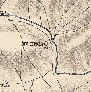
Yubla, was a Palestinian village, located 9 kilometers north of Bisan in present-day Israel. It was depopulated during the 1948 Arab-Israeli war.

Subbarin was a Palestinian Arab village located 28 kilometers south of Haifa. It was depopulated and destroyed during the 1948 Palestine war as part of the 1948 Palestinian expulsion and the Nakba.

Kawkab al-Hawa, is a depopulated former Palestinian village located 11 km north of Baysan. It was built within the ruins of the Crusader fortress of Belvoir, from which it expanded. The Crusader names for the Frankish settlement at Kawkab al-Hawa were Beauvoir, Belvoir, Bellum videre, Coquet, Cuschet and Coket. During Operation Gideon in 1948, the village was occupied by the Golani Brigade and depopulated.
Arab al-Bawati, was a Palestinian Arab village in the District of Baysan. It was depopulated during the 1948 Arab-Israeli War.
Tall al-Shawk, was a Palestinian village in the District of Baysan. It was depopulated by the Israel Defense Forces during the 1947–1948 Civil War in Mandatory Palestine on May 12, 1948, as part of Operation Gideon. It was located five km west of Baysan between the al-Januna'in River to the north and Wadi al-Jawsaq to the south. The village was built above an ancient archeological site and granite columns remain.
Al-Tira, was a Palestinian Arab village in the District of Baysan. It was depopulated by the Israel Defense Forces during the 1947–48 Civil War in Mandatory Palestine on 15 April 1948 as part of Operation Gideon under the command of Yosef Weitz. It was located 17.5 km north of Baysan overlooking Wadi al-Bira. However, 'Ayn al-Bayda' was the main source of drinking water for al-Tira inhabitants.

Umm 'Ajra, was a Palestinian Arab village in the District of Baysan. It was depopulated by the Israel Defense Forces during the 1948 Arab-Israeli War on May 31, 1948, as part of Operation Gideon. It was located 4 km south of Baysan and the 'Ayn Umm 'Ajra provided the village with water.

Al-Rihaniyya was a Palestinian Arab village in the Haifa Subdistrict. It was depopulated during the 1947–1948 Civil War in Mandatory Palestine on 30 April 1948 as part of the battle of Mishmar HaEmek. It was located 25 km southeast of Haifa and 3 km northwest of Wadi al-Mileh.

Al-Sawalima was a Palestinian Arab village in the Jaffa Subdistrict. It was depopulated during the 1947–1948 Civil War in Mandatory Palestine on March 30, 1948. It was located 11 km northeast of Jaffa, situated 2 km north of the al-'Awja River.

Al-Barriyya was a Palestinian village in the Ramle Subdistrict of Mandatory Palestine. It was depopulated during the 1948 Arab–Israeli War on July 10, 1948, as part of Operation Dani. It was located 5.5 km southeast of Ramla, on the eastern bank of Wadi al-Barriyya.

Daniyal was a Palestinian village in the Ramle Subdistrict that was located 5 km east of Ramla and southeast of Lydda. It was depopulated during the 1948 Arab–Israeli War on July 10, 1948, by the Yiftach Brigade under the first phase of Operation Dani, as part of the broader 1948 Palestinian expulsion and flight and Nakba.

Khirbat al-Duhayriyya was a Palestinian Arab village in the Ramle Subdistrict. It was depopulated during the 1948 Arab-Israeli War on July 10, 1948, by the Givati Brigade under the first phase of Operation Dani. It was located 6 km northeast of Ramla.

Al-Haditha was a Palestinian village in the Ramle Subdistrict. It was located 8 km northeast of Ramla, on the bank of Wadi al-Natuf. The site, now known as Tel Hadid, has yielded significant archaeological remains from many periods. Al-Haditha was depopulated during the 1948 Arab-Israeli War on July 12, 1948, under the first stage of Operation Dani.

Al-Khayma was a Palestinian Arab village in the Ramle Subdistrict of Mandatory Palestine. It was depopulated during the 1948 Arab–Israeli War on July 9, 1948, by the Givati Brigade of Operation An-Far. It was located 18.5 km south of Ramla.

Al-Maghar was a Palestinian Arab village in the Ramle Subdistrict of Mandatory Palestine. It was depopulated by the Givati Brigade during Operation Barak on 18 May 1948. It was located 12 km southwest of Ramla, situated north of Wadi al-Maghar.

Al-Mukhayzin was a Palestinian village in the Ramle Subdistrict. It was ethnically cleansed during the Nakba on April 20, 1948, by the Givati Brigade of Operation Har'el. It was located 10 km southwest of Ramla.

Al-Zuq al-Tahtani was a Palestinian Arab village in the Safad Subdistrict. It was depopulated during the 1947–1948 Civil War in Mandatory Palestine on May 11, 1948, by the Palmach's First Battalion of Operation Yiftach. It was located 30 km northeast of Safad.
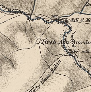
 1870s map
  1940s map
 modern map
  1940s with modern overlay map
