Al-Rihaniyya

Last updated

Contents

Al-Rihaniyya
Rihaniya, -al [1]
Etymology: "Sweet basil" [2] [3]
Historical map series for the area of al-Rihaniyya (1870s).jpg 1870s map
Historical map series for the area of al-Rihaniyya (1940s).jpg 1940s map
Historical map series for the area of al-Rihaniyya (modern).jpg modern map
Historical map series for the area of al-Rihaniyya (1940s with modern overlay).jpg 1940s with modern overlay map
A series of historical maps of the area around Al-Rihaniyya (click the buttons)
Mandatory Palestine location map.svg
Red pog.svg
Al-Rihaniyya
Location within Mandatory Palestine
Coordinates: 32°37′12″N35°05′13″E / 32.62000°N 35.08694°E / 32.62000; 35.08694
Palestine grid 158/225
Geopolitical entity Mandatory Palestine
Subdistrict Haifa
Date of depopulationNot known [1]
Population
 (1945)
  Total
240 [4] [5]
Current Localities Ramat HaShofet [2] Ein HaEmek [2]

Al-Rihaniyya was a Palestinian Arab village in the Haifa Subdistrict. It was depopulated during the 1947–1948 Civil War in Mandatory Palestine on 30 April 1948 as part of the battle of Mishmar HaEmek. It was located 25 km southeast of Haifa and 3 km northwest of Wadi al-Mileh.

History

In 1882, the PEF's Survey of Western Palestine described Kh. Rihaneh as a village containing the remnants of watch-towers and two springs. [6]

A population list from about 1887 showed that Rihaneh had about 190 inhabitants; all Muslims. [7]

Al-Rihaniyya had an elementary school for boys founded in 1888 that was no longer open during the British Mandate period. [2]

British Mandate era

In the 1922 census of Palestine, conducted by the British Mandate authorities, Al Rehaniyeh had a population of 266 Muslims, [8] increasing in the 1931 census to 293 Muslim, in a total of 55 houses. [9]

In the 1945 statistics, the village had a population of 240 Muslims, [4] and the village's lands spanned 1,930 dunams. [5] Of this, 1,761 dunums of land were used for cereals; 73 dunums were irrigated or used for orchards, [10] while 46 dunams were built-up (urban) land. [11]

1948, aftermath

On 5 April 1948, after the Battle of Mishmar HaEmek the Haganah ordered the Golani Brigade to inform the residents four Arab villages including Rihaniya that they should leave for safety reasons. [12]

On 14 April, The New York Times reported that Al-Rihaniyya was occupied, together with Daliyat al Ruha and Al-Butaymat. However Khalidi believes that the actual depopulation only happened two weeks later, during Passover Clearing. [2]

Surviving villagers told Rosemarie Esber that they decided to leave Al-Rihaniyya on 30 April, as "we did not have guns to defend it". They took refugee in Umm az-Zinat, but when the Haganah attacked it (according to the villagers: unprovoked) they fled "with nothing but our clothes on", to Ijzim. They stayed at Ijzim for several months, until it also was attacked by Zionist forces, who "kicked everybody out". Esbers informants ended up in Umm al-Fahm. [13]

Following the war the area was incorporated into the State of Israel, with the village's lands taken over by kibbutz Ramat HaShofet and the moshav of Ein HaEmek. [2]

According to Khalidi's description in 1992, the village site was strewn with housing rubble, bushes and thorns. The village cemetery and a well were visible at the bottom of a hill to the north. The surrounding land was farmed and an avocado orchard lay to the south. [14]

Related Research Articles

<span class="mw-page-title-main">Ijzim</span> Arab village in Mandatory Palestine

Ijzim was a Palestinian village in the Haifa Subdistrict of British Mandate Palestine, 19.5 kilometers south of Haifa, that was depopulated during the 1948 Arab-Israeli war. Many residents resettled in Jenin after Operation Shoter on 24 July 1948.

<span class="mw-page-title-main">Qannir</span> Village in Haifa, Mandatory Palestine

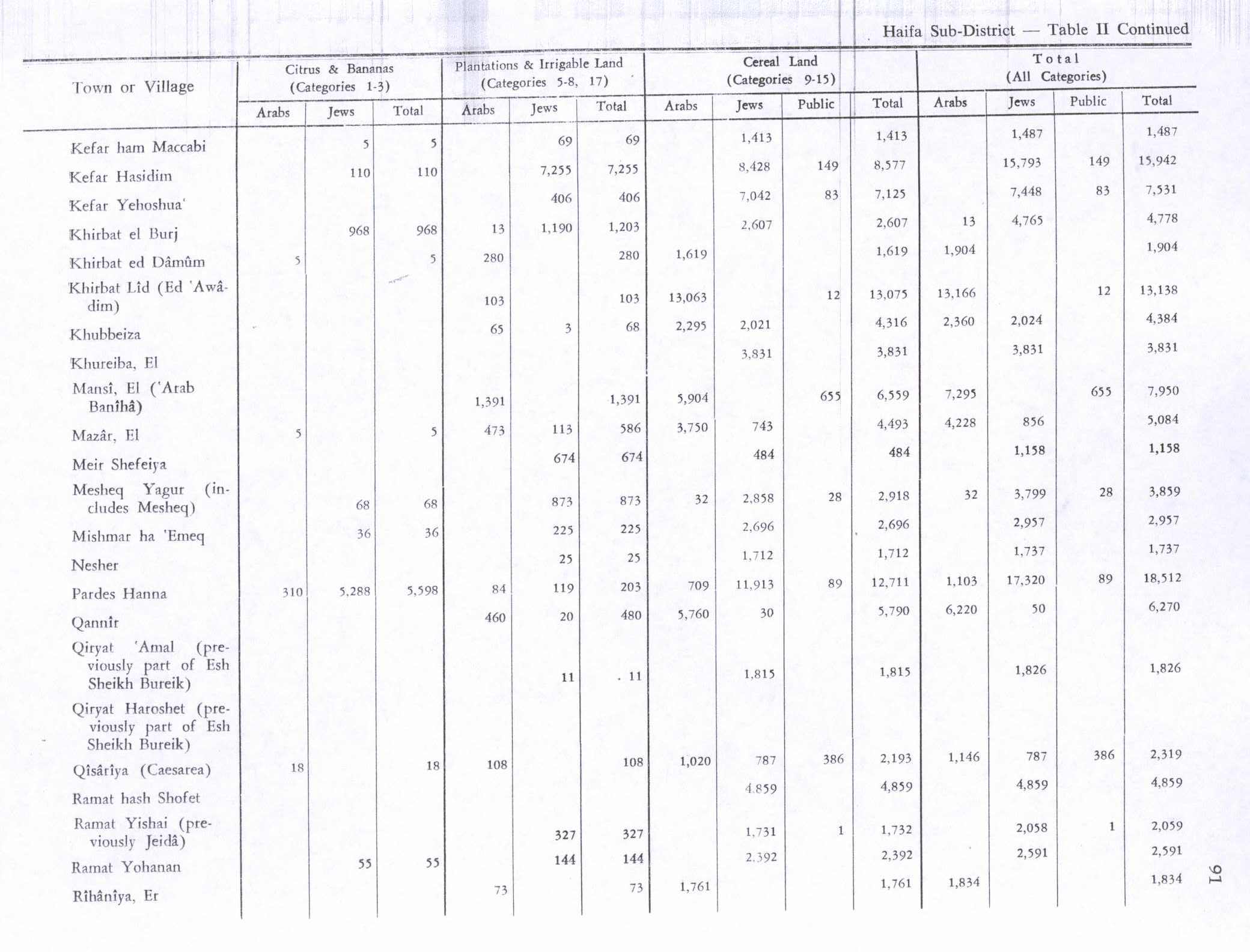
Qannir was a Palestinian village, located 35 kilometers south of Haifa. With 750 inhabitants in 1945, it was depopulated in the lead up to the 1948 Arab-Israeli war.

<span class="mw-page-title-main">Yubla</span> Village in Baysan, Mandatory Palestine

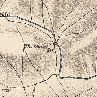
Yubla, was a Palestinian village, located 9 kilometers north of Bisan in present-day Israel. It was depopulated during the 1948 Arab-Israeli war.

<span class="mw-page-title-main">Al-Mansi</span> Former Palestinian village

Al-Mansi was a Palestinian village in the Haifa Subdistrict. It was occupied on 12 April 1948 by Israeli troops during the Battle of Mishmar HaEmek. The village was inhabited by Turkmens.

<span class="mw-page-title-main">Arab al-Bawati</span> Village in Baysan, Mandatory Palestine

Arab al-Bawati, was a Palestinian Arab village in the District of Baysan. It was depopulated during the 1948 Arab-Israeli War.

<span class="mw-page-title-main">Abu Shusha, Haifa</span> Arab village in Haifa subdistrict, Mandatory Palestine

Abu Shusha was a Palestinian Arab village in the Haifa Subdistrict. It was depopulated during the 1947–48 Civil War in Mandatory Palestine on 9 April 1948 during the Battle of Mishmar HaEmek. The village was inhabited by Turkmens.

<span class="mw-page-title-main">Burayka</span> Village in Haifa, Mandatory Palestine

Burayka was a Palestinian Arab village in the Haifa Subdistrict. It was depopulated during the 1947–1948 Civil War in Mandatory Palestine on May 5, 1948. It was located 29 km south of Haifa.

<span class="mw-page-title-main">Al-Butaymat</span> Village in Haifa, Mandatory Palestine

Al-Butaymat was a Palestinian Arab village the Haifa Subdistrict, located 31 kilometers (19 mi) southeast of Haifa. It was depopulated during the 1947–48 Civil War in Mandatory Palestine on May 1, 1948, under the Battle of Mishmar HaEmek.

<span class="mw-page-title-main">Daliyat al-Rawha'</span> Arab village in Haifa subdistrict, Mandatory Palestine

Daliyat al-Rawha' was a Palestinian village located 24.5 kilometers (15.2 mi) southeast of Haifa. It was the site of the signing of a ceasefire agreement between the forces of the Mamluks and the Crusaders in the 13th century. A small village of 60 Arab Muslims in the late 19th century, the kibbutz of Dalia was established on land purchased in the village in 1939. The population in 1945 reached 600 people: 280 Arabs and 320 Jews. It was depopulated of its Arab inhabitants in late March during the 1947–1948 civil war in Mandatory Palestine. Its remains lie at the very center of the Ramat Menashe Park of the JNF covered by the kibbutz of the same name.

<span class="mw-page-title-main">Al-Ghubayya al-Tahta</span> Village in Haifa, Mandatory Palestine

Al-Ghubayya al-Tahta was a Palestinian Arab village in the Haifa Subdistrict, located 28 km southeast of Haifa. It was depopulated during the 1947–48 Civil War in Mandatory Palestine on April 8, 1948, under the Battle of Mishmar HaEmek.

<span class="mw-page-title-main">Al-Kafrayn</span> Village in Haifa, Mandatory Palestine

Al-Kafrayn was a Palestinian village in the Haifa Subdistrict. It was depopulated during the 1947–48 Civil War in Mandatory Palestine on 12 April 1948 as part of the Battle of Mishmar HaEmek. It was located 29.5 km southeast of Haifa.

<span class="mw-page-title-main">Khirbat Al-Kasayir</span> Place in Haifa, Mandatory Palestine

Al-Kasayir was a Palestinian Arab village in the Haifa Subdistrict, located 13 km east of Haifa. It was depopulated during the 1947–48 Civil War in Mandatory Palestine on April 16, 1948, under the Battle of Mishmar HaEmek.

<span class="mw-page-title-main">Khubbayza</span> Village in Haifa, Mandatory Palestine

Khubbayza was a Palestinian Arab village in the Haifa Subdistrict, located 29.5 kilometers (18.3 mi) southeast of Haifa. It was situated on hilly terrain, south of Wadi al-Sindiyana, between the Jezreel Valley with the Mediterranean coast. In 1945, it had a population of 290. Khubbayza was depopulated during the 1948 War on May 12, 1948, in the Battle of Mishmar HaEmek.

<span class="mw-page-title-main">Khirbat Lid</span> Village in Haifa, Mandatory Palestine

Lid was a Palestinian village in the Haifa Subdistrict. It was depopulated during the 1948 Arab–Israeli War on April 9, 1948. It was 32 km southeast of Haifa.

<span class="mw-page-title-main">Umm az-Zinat</span> Place in Haifa, Mandatory Palestine

Umm az-Zinat was a Palestinian Arab village in the Haifa Subdistrict. It was depopulated during the 1948 War on May 15, 1948, by Golani Brigade's Fourth Battalion. It was located 20.5 km southeast of Haifa.

<span class="mw-page-title-main">Al-Khayma</span> Village in Ramle, Mandatory Palestine

Al-Khayma was a Palestinian Arab village in the Ramle Subdistrict of Mandatory Palestine. It was depopulated during the 1948 Arab–Israeli War on July 9, 1948, by the Givati Brigade of Operation An-Far. It was located 18.5 km south of Ramla.

<span class="mw-page-title-main">Jahula</span> Place in Safad, Mandatory Palestine

Jahula was a Palestinian Arab village in the Safad Subdistrict. It was depopulated during the 1947–1948 civil war in Mandatory Palestine on May 1, 1948, by the Palmach's First Battalion of Operation Yiftach. It was located 11 km northeast of Safad.

<span class="mw-page-title-main">Al-Na'ima</span> Place in Safad, Mandatory Palestine

Al-Na'ima was a Palestinian Arab village in the Safad Subdistrict of Mandatory Palestine located 26 kilometres (16 mi) northeast of Safad, near the al-Hula Plain. The settlement was depopulated during the 1947-1948 civil war on May 14, 1948 by the Israeli Palmach's First Battalion as part of Operation Yiftach.

<span class="mw-page-title-main">Al-Zahiriyya al-Tahta</span> Place in Safad, Mandatory Palestine

Al-Zahiriyya al-Tahta was a Palestinian Arab village in the Safad Subdistrict. The village was on a descent at the southwestern part of Safad, a town 1 kilometer (0.62 mi) east of the village. Possibly named after the Mamluk sultan al-Zahir Baybars, the village was incorporated into the Safad Sanjak of the Ottoman Empire in 1517, and its entirely Muslim population paid fixed taxes, as well as taxes on winter pastures, an olive oil or grape syrup press and beehives during the 16th century. By the late 19th century, the population grew to 335 inhabitants, all Muslims. The population remained about the same in the last years of British Mandatory rule. The village lands spanned 6,773 dunums, nearly half of which were used to grow grains, the residents living on 28 dunums. Al-Zahiriyya al-Tahta was depopulated during the 1948 Palestine War when its inhabitants fled shortly after the capture of Safed by Jewish paramilitary forces.

<span class="mw-page-title-main">Taytaba</span> Place in Safad, Mandatory Palestine

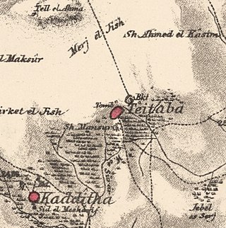
Taytaba was a Palestinian-Arab village in the Safad Subdistrict, located 5 kilometers north of Safad. It was depopulated during the 1947–1948 Civil War in Mandatory Palestine in May 1948 under Operation Hiram. In 1945 it had a population of 530 and a total area of 8,453 dunams, 99.8% of which was Arab-owned.

References

  1. 1 2 Morris, 2004, p. xviii, village #163. Gives both date and cause of depopulation as "Not known".
  2. 1 2 3 4 5 6 Khalidi, 1992, p. 185
  3. Palmer, 1881, p. 149
  4. 1 2 Department of Statistics, 1945, p. 14
  5. 1 2 Government of Palestine, Department of Statistics. Village Statistics, April, 1945. Quoted in Hadawi, 1970, p. 49
  6. Conder and Kitchener, 1882, SWP II, p. 62
  7. Schumacher, 1888, p. 179
  8. Barron, 1923, Table XI, Sub-district of Haifa, p. 34
  9. Mills, 1932, p. 95
  10. Government of Palestine, Department of Statistics. Village Statistics, April, 1945. Quoted in Hadawi, 1970, p. 91
  11. Government of Palestine, Department of Statistics. Village Statistics, April, 1945. Quoted in Hadawi, 1970, p. 141
  12. Morris, 2004, p. 241
  13. Esber, 2008 , p. 261
  14. Khalidi, 1992, p. 186

Bibliography