
Bayt Nabala or Beit Nabala was a Palestinian Arab village in the Ramle Subdistrict in Palestine that was destroyed during the 1948 Arab–Israeli War. The village was in the territory allotted to the Arab state under the 1947 UN Partition Plan, which was rejected by Arab leaders and never implemented. Its population in 1945, before the war, was 2,310.

Kudna was a Palestinian Arab village, located 25 kilometers northwest of Hebron.

Ra'na was a village located approximately 26 km northwest of Hebron. It was occupied by the Israeli army during Operation Yo'av in October 1948. It was one of 16 villages in the Hebron district that were depopulated.

Deir Qaddis is a Palestinian town in the Ramallah and al-Bireh Governorate of the State of Palestine, in the central West Bank, located sixteen kilometers west of Ramallah. According to the Palestinian Central Bureau of Statistics, the town had a population of 2,452 inhabitants in 2017. The town consists of 8,207 dunams, of which 438 dunams are classified as built-up area. As a result of 1995 accords, 7.7% of Deir Qaddis' land was transferred to the Palestinian National Authority for civil affairs, so-called Area B, but Israel still retains full control of 92.3% of the town, being in Area C.

Deir 'Ammar is a Palestinian town in the Ramallah and al-Bireh Governorate, located 17 km (11 mi) northwest of Ramallah in the northern West Bank. According to the Palestinian Central Bureau of Statistics (PCBS), the town had a population of 3,353 inhabitants in 2017.

Al-Masmiyya al-Kabira was a Palestinian village in the Gaza Subdistrict, located 41 kilometers (25 mi) northeast of Gaza. With a land area of 20,687 dunams, the village site was situated on an elevation of 75 meters (246 ft) along the coastal plain. Established by immigrants from the Hauran in Syria, the village was depopulated during the 1948 Arab–Israeli War. Before the war, it had a population of 2,520 in 1945.

Dayr Sunayd was a Palestinian Arab village in the Gaza Subdistrict, located 12 kilometers (7.5 mi) northeast of Gaza. Situated at an elevation of 50 meters (160 ft) along the southern coastal plain of Palestine, Deir Sunayd had a total land area of 6,081 dunams. Prior to its depopulation during the 1948 Arab–Israeli War, it had 730 inhabitants in 1945.

Al-Batani al-Gharbi was a Palestinian village in the Gaza Subdistrict. It was depopulated during the 1947–48 Civil War in Mandatory Palestine on May 13, 1948, by the Giv'ati Brigade under Operation Barak. It was located 36 km (22 mi) northeast of Gaza.

Bil'in was a Palestinian Arab village in the Gaza Subdistrict. It was depopulated by the Israel Defense Forces during the 1948 Arab–Israeli War on July 8, 1948, under Operation An-Far. It was located 39 km northeast of Gaza and the village contained two wells which supplied it with drinking water.

Jusayr was a Palestinian Arab village in the Gaza Subdistrict. It was depopulated during the 1948 Arab-Israeli War on July 17, 1948, under Operation Barak or Operation Yo'av. It was located 35 km northeast of Gaza.

Barqusya was a Palestinian Arab village in the Hebron Subdistrict, depopulated in the 1948 Palestine War. It was located 31 km northwest of Hebron.
Dayr Aban was a Palestinian Arab village in the Jerusalem Subdistrict, located on the lower slope of a high ridge that formed the western slope of a mountain, to the east of Beit Shemesh. It was formerly bordered by olive trees to the north, east, and west. The valley, Wadi en-Najil, ran north and south on the west-side of the village.
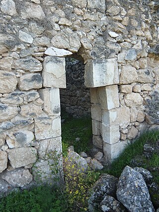
Dayr al-Hawa was a Palestinian Arab village in the Jerusalem Subdistrict. The village was depopulated during the 1948 Arab-Israeli War on October 19, 1948, by the Fourth Battalion of the Har'el Brigade of Operation ha-Har. It was located 18.5 km west of Jerusalem.
Khirbat Al-Lawz was a Palestinian Arab village in the Jerusalem Subdistrict. It was depopulated during the 1948 Arab-Israeli War on July 13, 1948, by the Har'el Brigade of Operation Dani. It was located 11 km west of Jerusalem, situated north of Wadi al-Sarar.

Ras Abu 'Ammar was a small Palestinian Arab village in the Jerusalem Subdistrict. It was depopulated during the 1948 Arab-Israeli War on October 21, 1948, by the Har'el Brigade of Operation ha-Har. It was located 14 km west of Jerusalem, surrounded on three sides by the Wadi al-Sarar.

Sufla was a Palestinian Arab village in the Jerusalem Subdistrict. It was depopulated during the 1948 Arab–Israeli War on October 19, 1948, by the Sixth Battalion of the Harel Brigade under Operation Ha-Har. It was located 18.5 km west of Jerusalem.

Dayr Ayyub was a Palestinian Arab village in the Ramle Subdistrict. It was depopulated during the 1947–48 Civil War in Mandatory Palestine on March 6, 1948 by the Givati and Sheva' brigades of Operation Nachshon. It was located 17.5 km southeast of Ramla, situated close to Bab al-Wad. On attack, the village was defended by the Jordanian Army but was mostly destroyed with the exception of a few houses and the village cemetery.

Dayr Muhaysin was a Palestinian village in the Ramle Subdistrict of Mandatory Palestine, located 12 km southeast of Ramla and 4 km west of Latrun. It was depopulated during the 1948 Palestine war.

Dayr Tarif was a Palestinian Arab village in the Ramle Subdistrict of Mandatory Palestine. It was depopulated during the 1948 Arab-Israeli War on July 10, 1948.

Al-Maghar was a Palestinian Arab village in the Ramle Subdistrict of Mandatory Palestine. It was depopulated by the Givati Brigade during Operation Barak on 18 May 1948. It was located 12 km southwest of Ramla, situated north of Wadi al-Maghar.
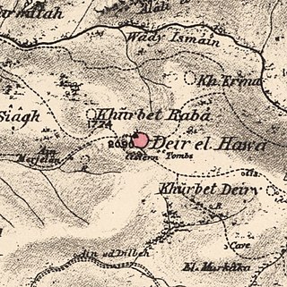
 1870s map
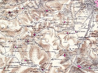
  1940s map
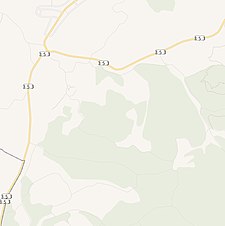 modern map
  1940s with modern overlay map
