Al-Mirr

Last updated

Contents

Al-Mirr
المرّ / المحمودية
Molendina desubter Mirabellum
Yarkon-47-mill.jpg
Remains of Mill building
Etymology: "The passage". [1]
Historical map series for the area of al-Mirr (1870s).jpg 1870s map
Historical map series for the area of al-Mirr (1940s).jpg 1940s map
Historical map series for the area of al-Mirr (modern).jpg modern map
Historical map series for the area of al-Mirr (1940s with modern overlay).jpg 1940s with modern overlay map
A series of historical maps of the area around Al-Mirr (click the buttons)
Mandatory Palestine location map.svg
Red pog.svg
Al-Mirr
Location within Mandatory Palestine
Coordinates: 32°06′43″N34°54′57″E / 32.11194°N 34.91583°E / 32.11194; 34.91583
Palestine grid 142/168
Geopolitical entity Mandatory Palestine
Subdistrict Jaffa
Date of depopulationFebruary or March, 1948 [2]
Area
[3]
  Total
51  dunams (5.1 ha or 13 acres)
Population
 (1945)
  Total
170 [4] [3]
Cause(s) of depopulationFear of being caught up in the fighting

Al-Mirr, also named Mahmudiyeh ("the property of Mahmud"), [1] was a Palestinian Arab village in the Jaffa Subdistrict, which was depopulated during the 1947–1948 Civil War in Mandatory Palestine on February 1, 1948.

Location

The village was located 16.5 kilometers (10.3 mi) northeast of Jaffa, on the southern bank of the al-'Awja river. A short, secondary track linked it to the railway line running between Ras al-Ayn and Petah Tikva. [5]

History

A mill and dam built at this site in late Roman/early Byzantine period were repaired in Crusader times. The mill was mentioned in Crusader sources in 1158/9 C.E. [6]

Excavations of the mill have recovered several 14th-century coins, which indicate that it was in use in the Mamluk period. [7]

Ottoman era

The modern village was founded during the reign of the Mahmud II (1808–39), the Sultan of the Ottoman Empire, and was also known as "Al Mahmudiyya". [5] In 1856 the village was named el Mir on Kiepert's map of Palestine published that year. [8]

In 1870 Victor Guérin visited and described the village (which he called Ma'moudieh): "It contains at most two hundred inhabitants, who live in houses built of adobe. Several mills are set in motion by the cascading waterfalls along the Nahr el-A'oudjeh. A small bridge over the river makes it possible to cross it at this point". [9] An Ottoman village list from about the same year indicated 30 houses and a population of 69, though the population count included men only. [10] [11]

The PEF's Survey of Western Palestine in 1882 described al-Mirr as "a small mud village, with mills close to the river." [12]

British Mandate era

During the British Mandate for Palestine, the population was recorded as 75 Muslims in the 1922 census, [13] and the village was classified as a hamlet in the Palestine Index Gazetteer. [5] In the 1931 census Mahmudiya had 101 inhabitants, still all Muslims, in 25 houses. [14]

In the 1945 statistics the population numbered 170 Muslims, [4] who worked in agriculture and with transportation. Cultivated lands in the village in 1944-45 included 2 dunums planted with citrus and bananas, and 31 dunums planted with cereals. [5] [15] 2 dunams were classified as built-up areas. [16]

Al-Mirr 1941 1:20,000 Al MIrr 1941.jpg
Al-Mirr 1941 1:20,000
Al-Mirr 1945 1:250,000 (top centre) Al Mirr 1945.jpg
Al-Mirr 1945 1:250,000 (top centre)

1948, and aftermath

Before the outbreak of the 1948 Arab-Israeli war, al-Mirr's inhabitants left on February 3, 1948, out of fear of Jewish attack. [17] According to Benny Morris, some of the inhabitants returned on February 15, but fled for the final time one month later. [17] However, according to Walid Khalidi, citing The New York Times , the villagers apparently returned yet again, as Jewish forces attacked the village in mid-May. [18] The 13 May attack would have occurred around the same time as an attack into the area by Irgun. [5]

The remains of a Turkish bridge lies where the village was. [5]

Andrew Petersen, an archaeologist specializing in Islamic architecture, visited the mill in 1991. He found that it had probably been built in several phases. Presently, it consists of a rectangular building, 60 m. N S x 10 m E W, on two levels. [19] At the lower level are at least 13 parallel water inlets. These inlets are of two different types, (indicating different construction date); a flat slab roof, and pointed vaulted roof. Between the two levels are holes in the floor, presumably this is where the millstones were connected to the turbines. [19]

See also

Related Research Articles

<span class="mw-page-title-main">Amka</span> Moshav in northern Israel

Amka, also Amqa, is a moshav in the Matte Asher Regional Council of Israel's Northern District, near Acre. The moshav, located in the vicinity of Amqa, a Palestinian village depopulated during the 1948 Arab–Israeli War, was founded by Yemenite Jews in 1949. In 2022, its population was 833.

<span class="mw-page-title-main">Al-Ruways</span> Place in Acre, Mandatory Palestine

Al-Ruways, was a Palestinian Arab village on a rocky hill located 12 kilometers (7.5 mi) southeast of Acre and south of the village of al-Damun. Its population in 1945 was 330. Al-Ruways was depopulated following its capture by Israeli forces during the 1948 Arab-Israeli War.

<span class="mw-page-title-main">Dayr al-Qassi</span> Place in Acre, Mandatory Palestine

Dayr al-Qassi or Deir el-Qasi, was a Palestinian Arab village located 26 km northeast of the city of Acre, which was depopulated during 1948 Arab-Israeli war.

<span class="mw-page-title-main">Al-Sumayriyya</span> Place in Acre, Mandatory Palestine

Al-Sumayriyya, was a Palestinian village located six kilometers north of Acre that was depopulated after it was captured by the Israel Defense Forces during the 1948 Arab-Israeli War. The ruins of the village are today in the outskirts of the Israeli moshav of Regba.

<span class="mw-page-title-main">Tarbikha</span> Place in Acre, Mandatory Palestine

Tarbikha, was a Palestinian Arab village. It was located 27 kilometres northeast of Acre in the British Mandate District of Acre that was captured and depopulated by the Israel Defense Forces during the 1948 Arab-Israeli war. The inhabitants of this village were, similar to the inhabitants of Southern Lebanon, Shia Muslims.

<span class="mw-page-title-main">Qula</span> Place in Ramle, Mandatory Palestine

Qula was a Palestinian village in the Ramle Subdistrict of Mandatory Palestine, located 15 km northeast of Ramla. Its residents had their origins in Jimzu, Ammuriya and other places.

<span class="mw-page-title-main">Biyar 'Adas</span> Place in Jaffa, Mandatory Palestine

Biyar 'Adas was a Palestinian Arab village located 19 km northeast of the city of Tel Aviv. In 1945 the village had a population of 300 and a total land area of 5,492 dunums.

<span class="mw-page-title-main">Fajja</span> Place in Jaffa, Mandatory Palestine

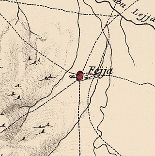
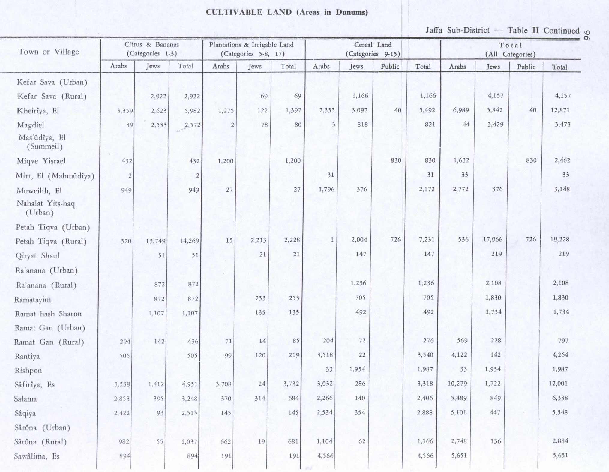
Fajja was a Palestinian town located 15 kilometers northeast of Jaffa. Ethnically cleansed during the Nakba, its land area is today part of the Israeli city of Petah Tikva.

<span class="mw-page-title-main">Rantiya</span> Place in Jaffa, Mandatory Palestine

Rantiya was a Palestinian village, located 16 kilometers east of Jaffa. During the British Mandate in Palestine, in 1945 it had a population of 590 inhabitants.

<span class="mw-page-title-main">Kafr Lam</span> Place in Haifa, Mandatory Palestine

Kafr Lam was a Palestinian Arab village located 26 kilometres (16 mi) south of Haifa on the Mediterranean coast. The name of the village was shared with that of an Islamic fort constructed there early in the period of Arab Caliphate rule in Palestine. To the Crusaders, both the fort and the village, which they controlled for some time in the 13th century, were known as Cafarlet.

<span class="mw-page-title-main">Bayt Jiz</span> Place in Ramle, Mandatory Palestine

Bayt Jiz was a Palestinian Arab village situated on undulating land in the western foothills of the Jerusalem heights, 15 kilometers (9.3 mi) southwest of Ramla. In 1945, it had a population of 550. It was occupied by Israeli forces in the 1948 Arab–Israeli War and became depopulated.

<span class="mw-page-title-main">Shahma</span> Village in Ramle, Mandatory Palestine

Shahma was a Palestinian Arab village located 15 kilometers (9.3 mi) southwest of Ramla. Depopulated on the eve of the 1948 Arab-Israeli war, the village lands today form part of a fenced-in area used by the Israeli Air Force.

<span class="mw-page-title-main">Sirin, Baysan</span> Place in Baysan, Mandatory Palestine

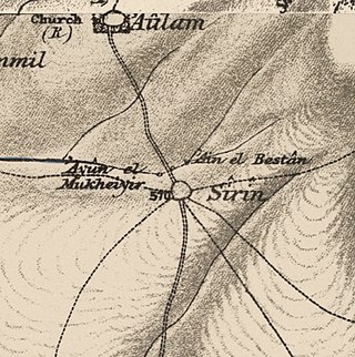
Sirin, was a Palestinian Arab village located 17 kilometers (11 mi) north of Beisan. The village was depopulated and destroyed in 1948. Only the village cemetery and one house remain standing, along with the remains of a mosaic pavement and a vaulted spring dating to the Byzantine period. Mentioned in historical documents, the 1596 census indicated it had 45 households; by 1945, the number of inhabitants had risen to 810.

<span class="mw-page-title-main">Dayr Nakhkhas</span> Place in Hebron, Mandatory Palestine

Dayr Nakhkhas was an Arab village located 20 km northwest of Hebron, overlooking Wadi Bayt Jibrin to the north.

<span class="mw-page-title-main">Aqqur</span> Place in Jerusalem, Mandatory Palestine

Aqqur was a Palestinian Arab hamlet in the Jerusalem Subdistrict. Founded in the Ottoman period, it had a population of 25 in 1922 and 40 in 1945. It was depopulated during the 1948 Arab-Israeli War on July 13, 1948, under Operation Dani. It was located 14.5 km west of Jerusalem on the Wadi Isma'il, a tributary of the Wadi al-Sarar.

<span class="mw-page-title-main">Dayr al-Hawa</span> Place in Jerusalem, Mandatory Palestine

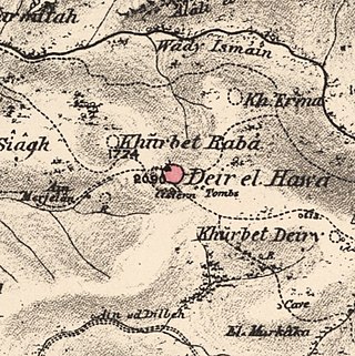
Dayr al-Hawa was a Palestinian Arab village in the Jerusalem Subdistrict. The village was depopulated during the 1948 Arab-Israeli War on October 19, 1948, by the Fourth Battalion of the Har'el Brigade of Operation ha-Har. It was located 18.5 km west of Jerusalem.

<span class="mw-page-title-main">Al-Qabu</span> Place in Jerusalem, Mandatory Palestine

Al-Qabu was a Palestinian Arab village in the Jerusalem Subdistrict. The name is an Arabic variation of the site's original Roman name, and the ruins of a church there are thought to date to the era of Byzantine or Crusader rule over Palestine.

<span class="mw-page-title-main">Bayt Susin</span> Place in Ramle, Mandatory Palestine

Bayt Susin was a Palestinian Arab village in the Ramle Subdistrict of Mandatory Palestine, located 17 kilometers (11 mi) southeast of Ramla. In 1945, it had 210 inhabitants. The village was depopulated during the 1948 war by the Israeli 7th Brigade.

<span class="mw-page-title-main">Bir Ma'in</span> Place in Ramle, Mandatory Palestine

Bir Ma'in was a Palestinian Arab village in the Ramle Subdistrict. It was depopulated during the 1948 Arab-Israeli War on July 15, 1948 during the second phase of Operation Danny by the First and Second Battalions of the Yiftach Brigade. It was located 14 km east of Ramla. The village was defended by the Jordanian Army.

<span class="mw-page-title-main">Al-Qubayba, Ramle</span> Arab village in Mandatory Palestine

Al-Qubayba was a Palestinian Arab village in the Ramle Subdistrict. It was depopulated during the 1948 Arab-Israeli War on May 27, 1948, by the Givati Brigade as part of the Second stage of Operation Barak. It was located 10.5 km southeast of Ramla near the Rubin River which provided the village with water and irrigation for agriculture. Al-Qubayba was mostly destroyed with the exception of a few houses, and Kfar Gevirol was built in its place, now a suburb in the west of Rehovot.

References

  1. 1 2 Palmer, 1881, p.216
  2. Morris, 2004, p. xviii, village #199. Also gives cause of depopulation
  3. 1 2 Government of Palestine, Department of Statistics. Village Statistics, April, 1945. Quoted in Hadawi, 1970, p. 52
  4. 1 2 Government of Palestine, Department of Statistics, 1945, p. 27
  5. 1 2 3 4 5 6 Khalidi, 1992, p.250.
  6. Röhricht, 1893, RRH No 330; cited in Pringle, 1997, p. 72
  7. Shkolnik, 1994, p32. Cited in Petersen, 2001, p. 222
  8. Kiepert, 1856, Map of Southern Palestine
  9. Guérin, 1875, p. 371
  10. Socin, 1879, p. 157
  11. Hartmann, 1883, p. 137, noted 26 houses
  12. Conder and Kitchener, 1882, II:252
  13. Barron, 1923, Table VII, Sub-district of Jaffa, p. 20
  14. Mills, 1932, p. 14
  15. Government of Palestine, Department of Statistics. Village Statistics, April, 1945. Quoted in Hadawi, 1970, p. 96
  16. Government of Palestine, Department of Statistics. Village Statistics, April, 1945. Quoted in Hadawi, 1970, p. 146
  17. 1 2 Morris, 2004, p. 129
  18. Khalidi, 1992, p. 250, citing The New York Times, 13.05.1948 and 13.05.1948. The NYT statement is based on British Army statement, which, according to Khalidi, incorrectly refers to the village of Antipatris
  19. 1 2 Petersen, 2001, p. 222-223

Bibliography