
Ishwa' was a Palestinian village which was depopulated during the 1948 Arab-Israeli war. The village was located about 20 km west of Jerusalem, on the present location of Eshta'ol. In the 1931 British census of Palestine, Ishwa had a population of 468 in 126 houses. The village was occupied by the Israel Defense Forces (IDF) on July 16, 1948, in Operation Dani by the Harel Brigade. All of its inhabitants fled or were expelled.

Ma'alul was a Palestinian village, with a mixed population of primarily Muslims with a substantial minority of Palestinian Christians, that was depopulated and destroyed by Israel during the 1948 Arab-Israeli war. Located six kilometers west of the city of Nazareth, many of its inhabitants became internally displaced refugees, after taking refuge in Nazareth and the neighbouring town of Yafa an-Naseriyye. Despite having never left the territory that came to form part of Israel, the majority of the villagers of Maalul, and other Palestinian villages like Andor and Al-Mujidal, were declared "absentees", allowing the confiscation of their land under the Absentees Property Law.

Bayt Nabala or Beit Nabala was a Palestinian Arab village in the Ramle Subdistrict in Palestine that was destroyed during the 1948 Arab–Israeli War. The village was in the territory allotted to the Arab state under the 1947 UN Partition Plan, which was rejected by Arab leaders and never implemented. Its population in 1945, before the war, was 2,310.
Bayt Jirja or Beit Jerja was a Palestinian Arab village 15.5 km Northeast of Gaza. In 1931 the village consisted of 115 houses. It was overrun by Israeli forces during operation Yo'av in the 1948 Arab-Israeli war. Bayt Jirja was found depopulated in November 1948, during "clean up sweeps" to expel any partial inhabited villages and destroy village housing to prevent any possible re-occupation in the area. The village was completely destroyed after the occupation and only one tomb remains.

Bayt Daras was a Palestinian Arab town located 46 kilometers (29 mi) northeast of Gaza and approximately 50 meters (160 ft) above sea level. The village was depopulated and destroyed during the 1948 Palestine war, as part of the 1948 Palestinian expulsion and the Nakba.

Yasur was a Palestinian village, located 40 kilometres northeast of Gaza, that was depopulated during the 1948 Arab–Israeli War. Its inhabitants fled a military assault by the First Battalion of Israel's Givati Brigade on 9 June 1948, part of Operation Barak.

Miska was a Palestinian village, located fifteen kilometers southwest of Tulkarm, depopulated in 1948.

Indur was a Palestinian village, located 10.5 kilometres (6.5 mi) southeast of Nazareth. Its name preserves that of ancient Endor, a Canaanite city state thought to have been located 1 kilometre (0.62 mi) to the northeast. The village was depopulated during the 1948 Arab–Israeli War and its inhabitants became refugees, some of whom were internally displaced. In Israel today, there are a few thousand internally displaced Palestinians who hail from Indur, and continue to demand their right of return.

Al-Shajara was a Palestinian Arab village depopulated by Israel during the 1948 Arab-Israeli War when its residents were forcefully evacuated and became refugees. It was located 14 kilometers west of Tiberias on the main highway to Nazareth near the villages of Lubya and Hittin. The village was very close to the city of Nazareth, about 5 kilometers away.

Qaddita was a Palestinian Arab village of 240, located 4.5 kilometers (2.8 mi) northwest of Safad. It was captured and depopulated in the 1948 Arab-Israeli War, with some of its inhabitants expelled or fleeing to nearby 'Akbara where they live as internally displaced Palestinians and others to refugee camps in Lebanon or Syria.

Idnibba was a Palestinian village, located at latitude 31.7426937N and longitude 34.8561001,E in the southern part of the Ramle Subdistrict. It was depopulated in 1948, at which time its population was 568, and its lands are now used by Kfar Menahem.

Dayr Sunayd was a Palestinian Arab village in the Gaza Subdistrict, located 12 kilometers (7.5 mi) northeast of Gaza. Situated at an elevation of 50 meters (160 ft) along the southern coastal plain of Palestine, Deir Sunayd had a total land area of 6,081 dunams. Prior to its depopulation during the 1948 Arab–Israeli War, it had 730 inhabitants in 1945.

Bayt Tima was a Palestinian Arab village in the Gaza Subdistrict, located 21 kilometers (13 mi) northeast of Gaza and some 12 kilometers (7.5 mi) from the coastline. It was situated in flat terrain on the southern coastal plain of Palestine. Bayt Tima was depopulated during the 1948 Arab-Israeli War. Its population in 1945 was 1,060.

Al-Sawafir al-Shamaliyya was a Palestinian Arab village in the Gaza Subdistrict, located 33 kilometers (21 mi) northeast of Gaza situated along the southern coastal plain of Palestine 50 meters (160 ft) above sea level. It was one of three namesake villages, alongside Al-Sawafir al-Sharqiyya and Al-Sawafir al-Gharbiyya.

Al-Batani al-Sharqi was a Palestinian Arab village in the Gaza Subdistrict, located 36.5 kilometers (22.7 mi) northeast of Gaza situated in the flat terrain on the southern coastal plain of Palestine. It had a population of 650 in 1945. Al-Batani al-Sharqi was depopulated during the 1948 Arab-Israeli War.
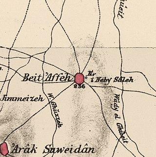
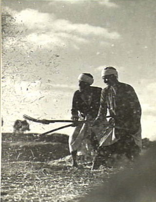
Bayt 'Affa was a Palestinian village in the Gaza Subdistrict. It was depopulated and destroyed during the 1947–48 Civil War in Mandatory Palestine. It was located 29 km (18 mi) northeast of Gaza and Wadi al-Rana ran east of the village.

Bil'in was a Palestinian Arab village in the Gaza Subdistrict. It was depopulated by the Israel Defense Forces during the 1948 Arab–Israeli War on July 8, 1948, under Operation An-Far. It was located 39 km northeast of Gaza and the village contained two wells which supplied it with drinking water.

Ni'ilya was a Palestinian village in the Gaza Subdistrict. It was depopulated during the 1948 Arab–Israeli War on November 4, 1948, under Operation Yo'av. It was located 19 km northeast of Gaza in the city territory of modern Ashkelon. The village was defended by the Egyptian Army.

Al-Qubayba was a Palestinian Arab village in the Ramle Subdistrict. It was depopulated during the 1948 Arab-Israeli War on May 27, 1948, by the Givati Brigade as part of the Second stage of Operation Barak. It was located 10.5 km southeast of Ramla near the Rubin River which provided the village with water and irrigation for agriculture. Al-Qubayba was mostly destroyed with the exception of a few houses, and Kfar Gevirol was built in its place, now a suburb in the west of Rehovot.

Qabba'a was a Palestinian Arab village in the District of Safad. It was depopulated during the 1948 War on May 26, 1948, by the Palmach's First Battalion of Operation Yiftach. It was located 6 km northeast of Safad.
 1870s map
  1940s map
 modern map
  1940s with modern overlay map


